
Racetrack Playa facts for kids
Quick facts for kids Racetrack Playa |
|
|---|---|
 |
|

Racetrack Playa
Location in California
|
|
| Location | Death Valley National Park Inyo County, California |
| Coordinates | 36°40′53″N 117°33′46″W / 36.6813°N 117.5627°W |
| Lake type | Endorheic basin |
| Primary outflows | Terminal (evaporation) |
| Basin countries | United States |
| Max. length | 4.5 km (2.8 mi) |
| Max. width | 2 km (1.2 mi) |
| Surface area | 7 km2 (2.7 sq mi) |
| Shore length1 | 12 km (7.5 mi) |
| Surface elevation | 1,132 m (3,714 ft) |
| 1 Shore length is not a well-defined measure. | |
The Racetrack Playa, or The Racetrack, is a scenic dry lake in Death Valley National Park, California, U.S.A. It's famous for its "sailing stones" that move across the flat surface, leaving long, mysterious tracks. This unique place is located high up on the northwestern side of Death Valley.
Contents
Exploring Racetrack Playa
Where is Racetrack Playa?
The Racetrack Playa sits about 1,132 meters (3,714 feet) above sea level. It is about 4.5 kilometers (2.8 miles) long from north to south and 2 kilometers (1.3 miles) wide from east to west. The playa is incredibly flat. The northern end is only about 3.8 centimeters (1.5 inches) higher than the southern end. This flatness happens because fine dirt washes into the northern part.
The highest point around the Racetrack is Ubehebe Peak, which is 1,731 meters (5,678 feet) tall. It rises about 599 meters (1,964 feet) above the lakebed to the west.
How the Lakebed Forms
The playa is in a small valley called an endorheic basin. This means water flows into it but doesn't flow out to a river or ocean. Instead, the water stays in the basin and evaporates. The valley is between the Cottonwood Mountains to the east and the Nelson Range to the west.
When it rains a lot, water rushes down from the mountains into the playa. This forms a shallow, temporary lake. But the hot desert sun quickly makes the water disappear. What's left behind is a layer of soft, slippery mud. As the mud dries, it shrinks and cracks into a pattern of interlocking shapes called polygons.
Scientists have even compared the shape of a lake on Saturn's moon Titan, called Ontario Lacus, to Racetrack Playa!

Amazing Features of The Racetrack
The Dry Lakebed
The Racetrack is dry for most of the year and has no plants growing on it. When it's dry, its surface is covered with small, firm hexagonal mud cracks. These cracks are usually 7.5 to 10 centimeters (3 to 4 inches) wide and about 2.5 centimeters (1 inch) thick. They form in sets of three cracks at 120-degree angles to each other.
After it rains, tiny mud curls, sometimes called "corn flakes," can form on the playa surface. If you don't see these, it means wind or something else has scraped them away.

During the rainy seasons (summer and especially winter), a thin layer of water covers the playa. This water deposits a thin layer of fine mud on and between the mud polygons. Heavier winter rains can temporarily erase the old cracks. New mud cracks form in the spring when the dry weather returns. Strong winds also help to smooth the edges of the exposed polygons.
The area gets about 75 to 100 millimeters (3 to 4 inches) of rain each year. Ice can also form, sometimes 2.5 to 6.5 centimeters (1 to 2.5 inches) thick. Usually, only part of the playa floods in any given year.
The Mysterious Sailing Stones
The sailing stones are the most famous feature of the Racetrack. These are slabs of rock, made of dolomite and syenite, that weigh from a few hundred grams to hundreds of kilograms. They slide across the playa surface, leaving visible tracks, without any help from humans or animals.
For a long time, how these rocks moved was a mystery! But scientists have figured it out. The rocks move when very thin sheets of ice (just a few millimeters thick) start to melt during light winds. These floating ice panels push the rocks, making them slide at speeds up to five meters per minute.
A documentary called Principles of Curiosity in 2017 explored how the mystery of the sailing stones was solved using the scientific method and critical thinking.
The Grandstand and Other Islands

Two "islands" of rock stick up dramatically from the playa's flat surface at its northern end. The larger and more famous one is The Grandstand. It's a dark rock formation about 22 meters (73 feet) high, standing out against the bright white surface of the Racetrack. The second "island" is a smaller rock outcrop.
Hidden Springs
There are three areas with lines of small dips or holes in the playa. These are places where water sometimes comes up from underground, like tiny intermittent springs.
- Spinal Springs is in the middle of the Racetrack playa. It's about 550 meters long. At its northern end, it has small, shallow dips. As you go south, the dips get wider (up to about 5 meters) and have some creosote shrubs growing around them. Then they get narrower and shallower again before disappearing.
- Edge Springs is a line of dips along the southeastern edge of the Racetrack playa. It runs parallel to the base of the steep mountains.
- Gindarja Springs is another line of dips, with three large ones in a northwesterly direction within the playa. Two are fully in the playa, and one is on the edge. All three have noticeable plants growing around them.
Visiting Racetrack Playa
To get to Racetrack Road, you usually go through Grapevine Junction near Scotty's Castle. The road from Ubehebe Crater is about 28 miles long and is a rough gravel road. You don't need a 4WD vehicle, but your car should have high ground clearance (meaning it sits high off the ground). The road goes around the western side of the playa to a parking area. Here, you'll find signs from the National Park Service that explain the area. There's also a bench where you can enjoy views of The Racetrack, The Grandstand, and the mountains.
Another way to reach Racetrack Playa is by Lippincott Pass Road, which comes from the southwest, climbing up from Saline Valley. Lippincott Pass and the roads in Saline Valley are extremely rough. You will need a high-clearance 4WD vehicle with special all-terrain tires for these roads.
You are not allowed to camp directly on the playa. However, there are "primitive campsite" areas to the north and south where you can camp.
Visiting remote parts of Death Valley can be risky. Summer temperatures can go above 49°C (120°F). Many areas have no cell phone service. The roads can be dangerous, and the closest gas station is in Panamint Springs. Always be prepared and careful when visiting!
Images for kids
-
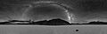
360° night-time panorama of the Racetrack Playa. The Milky Way is the visible arc in the center above a sailing stone and tracks from others.
See also
 In Spanish: Racetrack Playa para niños
