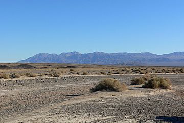
Avawatz Mountains facts for kids
Quick facts for kids Avawatz Mountains |
|
|---|---|

Seen from the north, in Death Valley
|
|
| Highest point | |
| Elevation | 1,872.7 m (6,144 ft) |
| Geography | |
| Country | United States |
| State | California |
| District | San Bernardino County |
| Range coordinates | 35°30′25″N 116°17′05″W / 35.50694°N 116.28472°W |
| Topo map | USGS Sheep Creek Spring |
The Avawatz Mountains are a mountain range found in San Bernardino County, California. They are located in the dry and vast Mojave Desert.
Contents
Discover the Avawatz Mountains
These mountains are a part of the unique landscape of Southern California. They offer a glimpse into the natural beauty of the desert.
What's in a Name?
The name "Avawatz" has an interesting history. One idea is that it comes from the Mohave Indian term "Avi-Ahwat." This term means "red rock," which might describe the mountains' appearance.
Another idea suggests the name comes from the Southern Paiute language. In their language, the word iva-wätz means "white mountain sheep." This could refer to animals that once lived there.
Where are the Avawatz Mountains?
The Avawatz Mountains are located to the west of California State Route 127. They sit between two other mountain ranges. To the north are the Owlshead Mountains, which are near Death Valley National Park. To the south, you'll find the Soda Mountains, close to the town of Baker.
Restricted Areas
A part of the Avawatz Mountain range is within a special area. This area is called the National Training Center. It is part of the Fort Irwin Military Reservation. Because it's a training area, this part of the mountains is not open to the public.
How Tall are They?
The Avawatz Mountains reach a significant height. Their highest point is about 1,872.7 meters (or 6,144 feet) above sea level. This makes them a notable feature in the desert landscape.
 | Mary Eliza Mahoney |
 | Susie King Taylor |
 | Ida Gray |
 | Eliza Ann Grier |


