Baker, California facts for kids
Quick facts for kids
Baker, California
|
|
|---|---|
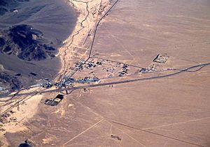
Aerial view of Baker looking north: I-15 jogs south around the town, leaving Baker Boulevard, the main street, to show where the pre-interstate highway (US 91 and US 466) went. Baker Airport sits just north of the city alongside northbound CA 127, the "Death Valley Road".
|
|
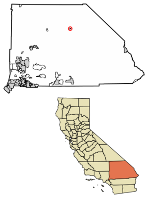
Location in San Bernardino County and the state of California
|
|
| Country | |
| State | |
| County | San Bernardino |
| Area | |
| • Total | 2.69 sq mi (6.96 km2) |
| • Land | 2.69 sq mi (0.00 km2) |
| • Water | 0.00 sq mi (0.00 km2) 0% |
| Elevation | 942 ft (287 m) |
| Population
(2020)
|
|
| • Total | 442 |
| • Density | 164.43/sq mi (63.49/km2) |
| Time zone | UTC-8 (Pacific) |
| • Summer (DST) | UTC-7 (PDT) |
| ZIP codes |
92309
|
| Area codes | 442/760 |
| FIPS code | 06-03512 |
| GNIS feature IDs | 238894, 2628708 |
Baker is a small community located in San Bernardino County, California, US. It is officially known as a census-designated place, which means it's a specific area identified by the Census Bureau for statistical purposes. As of the 2020 census, about 442 people live here. Baker's ZIP Code is 92309.
Contents
History of Baker, California
Baker was first established in 1908 as a station for the Tonopah and Tidewater Railroad. It was named after Richard C. Baker, who was a business partner in building the railroad. He later became the president of the railroad company.
Another important person in Baker's history was Ralph Jacobus Fairbanks. He helped establish several towns in the Death Valley area, including Baker, starting in 1929. For a while, Baker was also home to a large private prison facility.
Geography and Climate in Baker
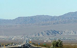
Baker is located in the Mojave Desert. It sits right where Interstate 15 and SR 127 (also called Death Valley Road) meet. The town is about 942 feet (287 meters) above sea level. This is lower than nearby cities like Barstow or Las Vegas. This is because Baker is at the southern end of the Death Valley area. The Cronese Mountains are to the southwest.
Baker covers an area of about 2.7 square miles (7.0 square kilometers), all of it land. Summers in Baker are extremely hot. Temperatures often go above 110°F (43°C). In 2007, a record high of 125°F (52°C) was recorded.
| Climate data for Baker, California. | |||||||||||||
|---|---|---|---|---|---|---|---|---|---|---|---|---|---|
| Month | Jan | Feb | Mar | Apr | May | Jun | Jul | Aug | Sep | Oct | Nov | Dec | Year |
| Record high °F (°C) | 82 (28) |
92 (33) |
97 (36) |
106 (41) |
116 (47) |
120 (49) |
124 (51) |
124 (51) |
119 (48) |
110 (43) |
95 (35) |
86 (30) |
124 (51) |
| Mean daily maximum °F (°C) | 63.1 (17.3) |
68.6 (20.3) |
76.8 (24.9) |
84.3 (29.1) |
94.9 (34.9) |
104.8 (40.4) |
110.2 (43.4) |
107.9 (42.2) |
100.2 (37.9) |
87.1 (30.6) |
72.6 (22.6) |
62.4 (16.9) |
86.1 (30.1) |
| Mean daily minimum °F (°C) | 34.6 (1.4) |
39.4 (4.1) |
45.6 (7.6) |
51.7 (10.9) |
61.3 (16.3) |
70.2 (21.2) |
77.0 (25.0) |
75.4 (24.1) |
67.2 (19.6) |
54.7 (12.6) |
42.8 (6.0) |
33.9 (1.1) |
54.5 (12.5) |
| Record low °F (°C) | 9 (−13) |
19 (−7) |
23 (−5) |
32 (0) |
38 (3) |
43 (6) |
53 (12) |
54 (12) |
42 (6) |
32 (0) |
20 (−7) |
13 (−11) |
9 (−13) |
| Average precipitation inches (mm) | 0.47 (12) |
0.71 (18) |
0.51 (13) |
0.20 (5.1) |
0.11 (2.8) |
0.07 (1.8) |
0.27 (6.9) |
0.46 (12) |
0.41 (10) |
0.25 (6.4) |
0.31 (7.9) |
0.41 (10) |
4.19 (106) |
| Source: The Western Regional Climate Center | |||||||||||||
People of Baker
| Historical population | |||
|---|---|---|---|
| Census | Pop. | %± | |
| 2010 | 735 | — | |
| 2020 | 442 | −39.9% | |
| U.S. Decennial Census 1850–1870 1880-1890 1900 1910 1920 1930 1940 1950 1960 1970 1980 1990 2000 2010 |
|||
In 2010, Baker had a population of 735 people. By 2020, the population was 442. Most people in Baker live in households.
The community is diverse. According to the 2010 census, about 68% of the people identified as Hispanic or Latino. The median age in Baker was about 26 years old. This means half the population was younger than 26 and half was older.
Baker's Economy
Baker's main source of income comes from tourism. The town is a popular stop for drivers traveling on Interstate 15 between Los Angeles and Las Vegas. It's about 90 miles (145 km) southwest of Las Vegas.
Baker is also the last town for those heading north on SR 127 to Death Valley National Park. It's also a gateway for those going south to the Mojave National Preserve. There used to be a motel in Baker, but it has since closed.
Mars Rover Test Site
Did you know that the desert near Baker was used for testing? The team building the Curiosity rover for Mars tested an engineering model here. This helped them prepare the rover for its mission on the Red Planet.
Education in Baker
Students in Baker attend schools within the Baker Valley Unified School District.
Fun Things to See and Do in Baker
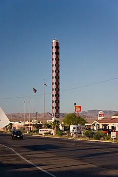
- The World's Tallest Thermometer: This huge thermometer is 134 feet (41 meters) tall. Its height celebrates the hottest temperature ever recorded on Earth, which was 134°F (57°C) in nearby Death Valley in 1913. A local businessman named Willis Herron built it in 1991 to attract more visitors. It was damaged by strong winds once but was quickly rebuilt. After some years, it was turned off due to high electricity costs. However, it was bought and fixed up by Herron's widow, Barbara, and relit on July 10, 2014. It was even featured on a TV show called Strange Inheritance.
- Alien Fresh Jerky: This is a unique store that sells different kinds of jerky and alien-themed souvenirs. The store itself is an attraction, with alien statues and buildings that look like spaceships. You'll often see billboards for it along I-15.
- Abandoned Buildings: Some old buildings, like the tiki-style Arnie's Royal Hawaiian Motel and the Bun Boy Restaurant and Motel, are interesting to see. They show what the town looked like in the past.
- Dumont Dunes: A few miles away, you'll find the Dumont Dunes Off-Highway Vehicle Area. This is a popular spot for people who enjoy riding ATVs and other off-road vehicles.
- Zzyzx Road: Just west of Baker on I-15, you can find the exit for Zzyzx Road. This dirt road leads to Soda Springs. It's now a Desert Study Center run by the California State University.
- Baker to Vegas Race: Every year, a relay running race called "The Challenge Cup Relay: Baker to Vegas" is held. It's often just called "Baker to Vegas." Law enforcement agencies from all over, including international teams, participate in this exciting event.
See also
 In Spanish: Baker (California) para niños
 | Chris Smalls |
 | Fred Hampton |
 | Ralph Abernathy |


