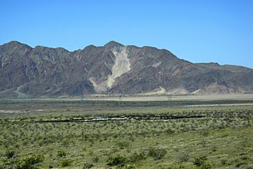
Cronese Mountains facts for kids
Quick facts for kids Cronese Mountains |
|
|---|---|

Cat Dune sand ramp, Cronese Mountains, California.
|
|
| Geography | |
| Country | United States |
| State | California |
| District | Mojave Desert, San Bernardino County, California |
| Range coordinates | 35°06′50″N 116°18′50″W / 35.1138708°N 116.3139092°W |
| Topo map | USGS |
The Cronese Mountains are a small mountain range located in the Mojave Desert in San Bernardino County, California. This area is part of the United States.
Where are the Cronese Mountains?
This small mountain range is found north of Interstate 15. It is southwest of the town of Baker. The mountains are also on the northwestern edge of a place called the Devils Playground and the Mojave National Preserve.
The Cronese Mountains are located at 35°06′50″N 116°18′50″W / 35.113871°N 116.313909°W. They are southwest of the Soda Mountains. The eastern part of the range sits between two dry lakes, East and West Cronese Dry Lakes. The historic Arrowhead Trail (also known as Arrowhead Highway) runs along the mountains near the main freeway.
How did the Cronese Mountains get their name?
The name of these mountains might come from Titus F. Cronise. He was an early pioneer and also wrote a book called The Natural Wealth of California.
 | Percy Lavon Julian |
 | Katherine Johnson |
 | George Washington Carver |
 | Annie Easley |


