Desolation Canyon facts for kids
Quick facts for kids Desolation Canyon |
|
|---|---|

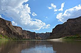
Desolation Canyon and the Green River,
August 2013 |
|
| Floor elevation | 4,318 feet (1,316 m) |
| Long-axis direction | North-South |
| Geology | |
| Type | River valley |
| Geography | |
| Location | Green River in Carbon, Emery, Grand, and Uintah counties in Eastern Utah, United States |
| Population centers | None (hence the name) |
| Borders on | East Tavaputs Plateau (eastern) West Tavaputs Plateau (western) |
| Traversed by | None |
| Rivers | Green River |
|
Desolation Canyon
|
|
| Location | Green River in Carbon, Emery, Grand, and Uintah counties in Eastern Utah, United States |
| Nearest city | East Carbon, Utah |
| NRHP reference No. | 68000057 |
| Significant dates | |
| Added to NRHP | November 24, 1968 |
| Designated NHL | November 24, 1968 |
Desolation Canyon is a huge, wild canyon in eastern Utah, United States. It's located along the Green River. This canyon is so remote that it's considered one of the most isolated places in the entire United States! It's also a special historical site, listed on the National Register of Historic Places.
Contents
Exploring Desolation Canyon's Location
Desolation Canyon starts in southwestern Uintah County, Utah. It winds south, forming the border between several counties. These include Uintah and Carbon counties, then Emery and Grand counties. The canyon ends near the Roan Cliffs. The Green River continues flowing south through Gray Canyon.
Desolation Canyon sits between two large land areas called plateaus. The West Tavaputs Plateau is on its west side, and the East Tavaputs Plateau is on its east side. At its deepest point, the canyon drops over 5,000 feet (1,500 m) from the top of the plateau to the river below.
A Glimpse into Desolation Canyon's Past
For thousands of years, different groups of people have lived in and around Desolation Canyon. They left behind clues about their lives.
Ancient Inhabitants and Their Art
The Fremont people and the Ute people lived here long ago. You can still find their amazing rock art, called pictographs and petroglyphs. These are drawings and carvings on rock walls. They are found throughout Desolation Canyon and its smaller canyons, like Nine Mile and Range Creek.
The Fremont people also built granaries. These were special storage buildings for their crops. Later, some homesteaders (people who settled on land to farm) built ranches here. This shows that the land near the river was good for farming. In fact, the farming areas in Desolation Canyon are larger than in any other canyon along the Colorado and Green River system.
Famous Explorers and Historic Sites
In 1869, a famous explorer named John Wesley Powell traveled through Desolation Canyon. He was on an expedition sponsored by the Smithsonian Institution.
One important place is Rock Creek Ranch. The Seamount family first settled it in 1914. Today, it's still used to graze horses by its current owners. This makes it the last property in the canyon that is still used for business.
Desolation Canyon was added to the National Register of Historic Places in 1968. It was also named a National Historic Landmark. This happened during the 100-year celebration of John Wesley Powell's expedition.
Fun Activities in Desolation Canyon
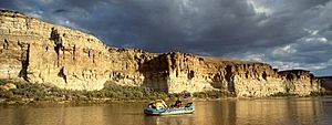
Many people love to go boating in Desolation Canyon. Each year, during spring, summer, and fall, boaters take an 83-mile (134 km) trip. This journey goes through Desolation and Gray canyons. It starts at Sand Wash and ends at Swasey's Rapid, near the city of Green River.
Boating Permits and Challenges
The Price office of the Bureau of Land Management manages this area. They issue permits for boating trips. If you want to camp or hike on the eastern side of the river, you used to need another permit. This side is part of the Uintah and Ouray Indian Reservation. However, as of spring 2015, the Ute people no longer offer permits to people who are not tribal members.
The canyon has over 60 named rapids. These are rated as class two and three. This means they are challenging but not too difficult. The rapids gradually get bigger, which makes it a great place for beginners to improve their boating skills. At very high water levels (over 20,000 cubic feet per second [570 m3/s]), a rapid called Joe Hutch Canyon Rapid (also known as Cow Swim) can become a class IV. This is much more difficult. Even at lower water levels, the rapids in the canyon are big enough to fill an open canoe with water.
See also
 In Spanish: Cañón de la Desolación (Utah) para niños
 | Stephanie Wilson |
 | Charles Bolden |
 | Ronald McNair |
 | Frederick D. Gregory |


