
Ninemile Canyon (Utah) facts for kids
Quick facts for kids Ninemile Canyon |
|
|---|---|

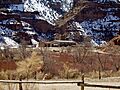
The Daddy Canyon area of Ninemile Canyon, November 2007
|
|

Ninemile Canyon
Location in Utah

Ninemile Canyon
Location in the United States
|
|
| Length | 40 miles (64 km) |
| Geography | |
| Traversed by | Utah State Route 53 |
| River | Nine Mile Creek |

Ninemile Canyon is a long canyon, about 40 miles (64 km) (64 km) long. It is found in eastern Utah, in Carbon and Duchesne counties. People call it "the world's longest art gallery." This is because it has tons of amazing rock art. Most of this art was made by the Fremont culture and the Ute people long ago.
The canyon is a cool place for archaeologists (people who study old things) and tourists. They come to see the rock art, old shelters, and granaries (places to store grain) left by the Fremont people.
In the 1880s, Ninemile Canyon became a main road for the area. Settlers built many ranches here. There was even a town called Harper, but it didn't last long. Today, the canyon road is not as busy. It's mostly used for fun trips and seeing the sights.
Since 2002, things have changed. People found lots of natural gas deep under the West Tavaputs Plateau. This brought many big trucks to the canyon. These trucks create a lot of dust. This dust might be harming the old rock art. People are now talking about how to use the canyon for energy while still keeping its amazing history safe.
Contents
Exploring Ninemile Canyon

Ninemile Canyon stretches from southwest to northeast. It has many twists and turns. It's located just north of the Book Cliffs. The full canyon road is about 78-mile (126 km) (126 km) long. It connects the towns of Wellington and Myton.
The canyon was formed by Nine Mile Creek. This creek is not very big. But it's super important because it's one of the few places in the area with water all year round. It has been a reliable water source since ancient times. Nine Mile Creek flows into the Green River. Many smaller canyons branch off Ninemile Canyon. These include Argyle Canyon and Cottonwood Canyon. Many important rock art sites are found where these smaller canyons meet the main one.
Ancient Art and People

Ninemile Canyon is home to an incredible amount of rock art. Experts believe there are at least 1,000 sites with over 10,000 individual images. Some even think the numbers could be ten times higher! This means it has more rock art than almost anywhere else in North America.
Most of the art is made of petroglyphs. These are images carved or pecked into the rock. There are also many pictographs, which are painted images.
The Fremont People
Researchers have also found hundreds of old pit-houses (homes dug into the ground), rock shelters, and granaries. Only a few of these have been dug up by archaeologists. Many of these buildings are high up on cliff ledges and mesas.
The Fremont people built these structures. They lived in Ninemile Canyon from about AD 950 to 1250. This canyon was one of the busiest places for the Fremont. Unlike other groups who only hunted and gathered food, the Fremont were farmers. They grew corn and squash along the canyon floor. They even had irrigation ditches to water their crops. These ditches could be seen until the 1930s.
The Ute People

By the 1500s, the ancestors of the Ute people were in the canyon. They added their own rock art to the walls. Their art styles were different from the Fremont's. For example, many Ute scenes show hunters on horseback. These pictures date back to the 1800s. Even though many Ute artifacts are found here, archaeologists haven't found any Ute camps or homes.
Protecting Ancient Sites

Many archaeological sites in the canyon are now listed on the U.S. National Register of Historic Places. This means they are very important and protected. In 2009, 63 sites were added. More were added in 2012 and 2014. These sites include Fremont buildings, rock art, and old homes from later times.
A Look Back in Time

The first clear sign of white people in the canyon is a carving on a wall. It says "S. Groesbeck August 19, 1867." John Wesley Powell's second trip down the Colorado River stopped near the canyon in 1871. The name Nine Mile Canyon first appeared in their records.
The Busy Road
The Nine Mile Canyon Road was built in 1886. It was built by the Buffalo Soldiers of the 9th Cavalry Regiment. This road connected Fort Duchesne to the railroad in Price. The road became very busy in 1889. This was after people found Gilsonite (a type of asphalt) in the Uinta Basin.
This road was the main way to travel in eastern Utah for many years. Most of the stagecoach, mail, and freight traffic went through Ninemile Canyon. This continued until the Uintah Railway arrived around 1905.
The Town of Harper
Because the road was so busy, people started to settle in the canyon. One of the main stagecoach stops grew into a town called Harper. It had a hotel, a store, a school, and a post office. Harper was not a typical town with a center. It was more like a long area with scattered ranches and buildings. The community grew until it became an official town in 1905. At its busiest in 1910, Harper had 130 people. But by the early 1920s, Harper became a ghost town.
Protecting the Canyon's Treasures

Today, rock art and other old items are protected by law. It's against the law to steal or damage them. But Ninemile Canyon's rock art is still at risk. The images are carved or painted on sandstone. This rock wears away easily. Touching the art makes it wear away faster. Also, dust in the air can damage it.
The dust is a big worry because of the heavy trucks in the canyon. The Nine Mile Canyon Road was mostly dirt until 2013. In 1990, the U.S. Bureau of Land Management (BLM) called it a Scenic Backcountry Byway. The road was paved in 2014. Now, 34 miles of the road are paved.
Natural Gas Development

Ninemile Canyon has unique archaeological sites. This has led to big discussions about how the land should be used. Some land in the canyon is public, and some is private. Old sites are found on both. Also, important minerals like natural gas have been found.
Since 2002, a company called Bill Barrett Corporation has been looking for natural gas. They are working with the BLM and private landowners. They believe there is about 1 trillion cubic feet of natural gas here. The company has spent a lot of money to improve the roads. If the project is fully approved, it could create many jobs.
Some groups are worried that not enough is being done to protect the canyon's natural and cultural treasures.
The Dust Problem


Before the road was paved, big trucks created huge clouds of dust. The dirt road was not built for such heavy traffic. The dust made it hard to see on the road. It also settled on the rock art. Carbon County tried to control the dust by putting magnesium chloride on the road. This chemical pulls moisture from the air to keep the dust down. But it might have caused more harm. The magnesium chloride dust might have drifted onto the rock walls.
A study in 2007 found that dust landing on rock art panels creates "a very serious conservation problem."
In 2004, Ninemile Canyon was named one of America's Most Endangered Places. This was because of energy development and more tourists. Many sites in the canyon have been added to the National Register of Historic Places. The BLM plans to nominate about 600 more sites in the future. This shows how important it is to protect this amazing place.
Images for kids
-
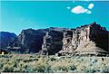
The Daddy Canyon area of Ninemile Canyon, November 2007
-
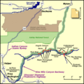
Map of Ninemile Canyon, from the National Scenic Byways Program
-
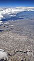
Ninemile Canyon (the dark green area at the bottom) at North Franks Canyon. An array of natural gas wells is visible in the distance, May 2019.
-
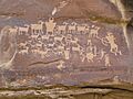
The famous Cottonwood Panel, also called The Great Hunt, May 2006
-
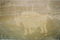
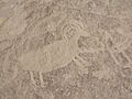
The prints under this bison's hooves indicate Ute origin, November 2007.
-
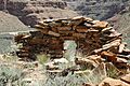
Stone shelter at Redman Village, April 2007
-
Rock art from Archaic to modern, November 2007
-
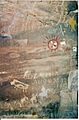
Defaced rock art in Rasmussen Cave, April 2007
-
Bill Barrett Corporation's natural gas compressor station, at the Dry Canyon junction, March 2008
-
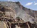
Road dust drifts up the canyon, March 2008.
-
Dust-covered petroglyphs, March 2008
