
Roan Cliffs facts for kids
The Roan Cliffs are a group of desert mountains and cliffs found in eastern Utah and western Colorado, in the western United States. They are very similar to, but separate from, the Book Cliffs.
Contents
What are the Roan Cliffs?
The Roan Cliffs are a long stretch of mountains and cliffs that are quite "remote and hard to reach." In contrast, the nearby Book Cliffs are much easier to see. They run along the edges of valleys like Castle Valley and Grand Valley. This means you can easily spot the Book Cliffs from cities like Price and Grand Junction. Because of this, the Book Cliffs are much more famous than the Roan Cliffs. Sometimes, people even use the name "Book Cliffs" to talk about both landforms.
The Roan Cliffs are located just north of the Book Cliffs and run roughly in the same direction. They stretch for almost 190 miles (306 km) from west to east.
Where do the Roan Cliffs begin?
The Roan Cliffs start in Utah, on the southern edge of the West Tavaputs Plateau. This is near the Willow Creek area, northwest of Helper. The cliffs then go southeast along the southern edge of the West Tavaputs Plateau. They pass through the northeast part of Emery County until they reach the Green River. The Green River flows through Desolation Canyon and Gray Canyon. This river also separates the West Tavaputs Plateau from the East Tavaputs Plateau.
How do the Roan Cliffs continue into Colorado?
After crossing the Green River and entering Grand County, the Roan Cliffs go through the southern part of the Uintah and Ouray Indian Reservation. They keep heading southeast along the southern edge of the East Tavaputs Plateau.
Eventually, the cliffs turn northeast. They continue in this direction until they reach the border between Utah and Colorado.
Once in Colorado, the Roan Cliffs continue their northeast path in Garfield County. They then turn southeast again, following the southern edge of the East Tavaputs Plateau. This path leads them to the Colorado River, near the town of De Beque.
The Roan Cliffs then briefly turn northeast along the Colorado River. This area is close to the highest point of the Roan Cliffs, called the Gardner Benchmark. It stands at 9,286 feet (2,830 m) high. Finally, the cliffs turn northwest and end just south of the border between Garfield and Rio Blanco counties. This is about 11.2 miles (18.0 km) northwest of the City of Rifle.
History of the Name
The Roan Cliffs were first named the Brown Cliffs by John Wesley Powell. He was an important explorer and the second Director of the United States Geological Survey. However, in 1932, the name was officially changed to Roan Cliffs. This new name was chosen because it better matched the roan color of the cliffs, which is a reddish-brown shade.
Images for kids
-
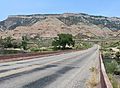
The cliffs above Rulison, Colorado

