
Funeral Mountains facts for kids
Quick facts for kids Funeral Mountains |
|
|---|---|

Pyramid Peak seen from Ash Meadows in Nevada
|
|
| Highest point | |
| Elevation | 2,043 m (6,703 ft) |
| Geography | |

Location in California
|
|
| Country | United States |
| State | California |
| District | Inyo County |
| Range coordinates | 36°23′30″N 116°36′43″W / 36.39167°N 116.61194°W |
| Topo map | USGS East of Echo Canyon |
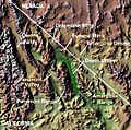
The Funeral Mountains are a dry, rugged mountain range in the United States. They are located right on the border between California and Nevada. These mountains are about 100 miles (160 km) west of the city of Las Vegas.
The Funeral Mountains are part of a larger group called the Amargosa Range. They form the eastern edge of Death Valley, a famous desert area. The highest point in the range is Pyramid Peak, which stands at 6,703 feet (2,043 meters) tall.
Contents
Exploring the Funeral Mountains
The very top parts of the Funeral Mountains are found inside Death Valley National Park. This means they are protected and offer amazing views. The mountains are separated from other ranges by narrow canyons and washes.
Where Are These Mountains?
To the northwest, the Funeral Mountains are separated from the Grapevine Mountains by a small area called Boundary Canyon. To the southwest, Furnace Creek Wash divides them from the Black Mountains. A narrow spot called Travertine Point separates them from the Greenwater Range to the south. Across the border in Nevada, to the northeast, you'll find the wide, flat lands of the Amargosa Desert.
Music Inspired by the Mountains
A famous composer named Ferde Grofé wrote a piece of music called the Death Valley Suite. The first part of this music paints a picture of early settlers. It describes them walking through the dry, rocky peaks of the Funeral Mountains. This shows how impressive and challenging these mountains can be.
Images for kids
-
Death Valley


