Greenwater Range facts for kids
Quick facts for kids Greenwater Range |
|
|---|---|

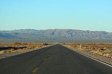
The Greenwater Range is on the horizon beyond Death Valley Junction.
|
|
| Highest point | |
| Elevation | 1,130 m (3,710 ft) |
| Geography | |
| Country | United States |
| State | California |
| District | Inyo County |
| Range coordinates | 36°10′18.841″N 116°32′48.151″W / 36.17190028°N 116.54670861°W |
| Topo map | USGS Greenwater Canyon |
The Greenwater Range is a group of mountains in California, United States. You can find them in the eastern part of the Mojave Desert. These mountains are located in Inyo County, California. They are west of California State Route 127, north of the town of Shoshone, California.
Where are the Greenwater Mountains?
The Greenwater Range is in a very dry area. It is close to several other mountain ranges. To the east, you'll find the Black Mountains. The Amargosa Range is to the north. The Nopah Range is to the southeast.
Nearby Towns and Parks
A small historic mining town called Ryan, California is in the northern part of the Greenwater Range. The southern part of these mountains is actually inside Death Valley National Park. This means some of the Greenwater Range is protected land.
To the east of the Greenwater Range is Death Valley Junction, California. This small community is famous for the Amargosa Opera House and Hotel. The Amargosa River also flows to the east of these mountains. Even though it's called a river, it's often dry!
 | DeHart Hubbard |
 | Wilma Rudolph |
 | Jesse Owens |
 | Jackie Joyner-Kersee |
 | Major Taylor |


