
Nopah Range facts for kids
Quick facts for kids Nopah Range |
|
|---|---|

Nopah Range as seem from the Chicago Valley
|
|
| Highest point | |
| Elevation | 1,941 m (6,368 ft) |
| Geography | |

Location in California
|
|
| Country | United States |
| State | California |
| District | Inyo County |
| Range coordinates | 36°0′21.873″N 116°4′49.084″W / 36.00607583°N 116.08030111°W |
| Topo map | USGS Nopah Peak |
The Nopah Range is a cool mountain range found in Inyo County, California, in the United States. It's located very close to California's eastern border with Nevada. Imagine a long line of mountains stretching across the desert landscape!
Exploring the Nopah Range's Location
This mountain range sits to the east of several other interesting places. You'll find the Resting Spring Range, the Owlshead Mountains, and the lower parts of Death Valley nearby. To the north, you'll see the Kingston Range. The Amargosa River flows to the west of the Nopah Range.
The Nopah Range is also close to several towns. It's directly east of Shoshone, California, and the Chicago Valley. To its northeast is Tecopa, California. If you head southwest, you'll reach Pahrump, Nevada, and to the west is Las Vegas, Nevada.
The mountains in the Nopah Range reach quite high. The tallest point is Nopah Peak, which is 6,395 feet (about 1,949 meters) above sea level. This peak is right in the middle of the range. The entire Nopah Range stretches for about 26 miles (about 42 kilometers).
Protecting the Nopah Range: Wilderness Areas
A big part of the Nopah Range is protected as a special place called the Nopah Range Wilderness. This wilderness area covers a huge 106,623 acres of the mountain range. It was set aside in 1994 by the U.S. Congress to keep it wild and untouched.
The U.S. Bureau of Land Management helps to take care of this wilderness area. In this protected space, the land goes from about 1,800 feet (548 meters) up to the highest point of 6,395 feet (1,949 meters).
There's also another smaller protected area called the South Nopah Range Wilderness. This part covers 17,059 acres. It includes the lower hills and edges of the mountain range. These wilderness areas help protect the natural beauty and wildlife of the Nopah Range for everyone to enjoy.
Images for kids
-
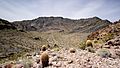
Looking south into the South Nopah Range Wilderness Area, Inyo County, California, 2017
-
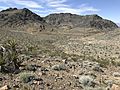
Looking at the Nopah Range Wilderness Area from about one mile north of the roadway, 2019
-
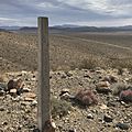
These granite markers appear here and there to mark what used to be the Old Spanish Trail, 2019
-
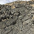
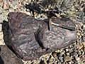
These craggy looking cliffs might appear to be volcanic but they are actually weathered limestone, 2019
-
Beautiful looking red quartzite boulders at this location, north of Emigrant Pass, 2019
-
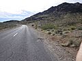
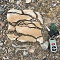
The road cut here near Emigrant Pass has been hunted for decades for trilobites, 2017
-
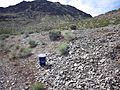
Trilobite hunting area next to the roadway has good access and easy parking, 2017
-
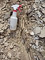
Misting or water bottle needed to reveal partial trilobites, 2017
-
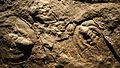
This site provides mostly partial trilobites. Finding a full bug is very hard, 2017
-
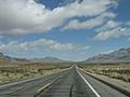
Nopah Range, near California State Route 127
-
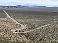
A gravel hauler works the grade up to the top of Emigrant Pass in the Nopah Range
-
Fractured sandstone in the North Nopah Wilderness Area


