Resting Spring Range facts for kids
Quick facts for kids Resting Spring Range |
|
|---|---|

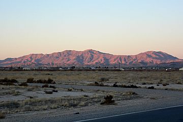
The Resting Spring Range as viewed from Pahrump, Nevada
|
|
| Highest point | |
| Peak | 13667 |
| Geography | |
| Country | United States |
| State | California |
| District | Inyo County |
| Range coordinates | 36°05′00″N 116°14′03″W / 36.08333°N 116.23417°W |
| Topo map | USGS Twelvemile Spring |
The Resting Spring Range is a cool group of mountains located in the eastern Mojave Desert in California. It's pretty close to the Nevada state line in the United States. These mountains stretch from north to south. You can find them west of the Nopah Range and southeast of the Amargosa Range and Greenwater Range.
These mountains are in Inyo County, California. They sit between the Amargosa River and California State Route 127 on their west side. To their east, you'll find Stewart and Chicago valleys, along with California State Route 178.
Protecting the Resting Spring Range
The Resting Spring Range Wilderness was created in 1994 by the U.S. Congress. This special area helps protect the mountains. It stretches between Death Valley National Park and the Nevada state line. It's part of a bigger system called the National Wilderness Preservation System.
What is the Wilderness Area Like?
This desert wilderness area covers a huge space of 76,312 acres. The Bureau of Land Management takes care of it. The height of the land here changes a lot. It goes from 2,040 feet (621 meters) up to 5,264 feet (1604 meters) at a spot called Stewart's Peak.
Nearby Wilderness Areas
The Nopah Range Wilderness is located to the south of the Resting Spring Range Wilderness. To the west, you'll find the Death Valley Wilderness. These areas work together to protect a large part of the desert environment.
 | Shirley Ann Jackson |
 | Garett Morgan |
 | J. Ernest Wilkins Jr. |
 | Elijah McCoy |


