Tecopa, California facts for kids
Quick facts for kids
Tecopa
|
|
|---|---|

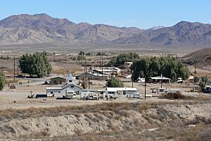
Tecopa from the southwest
|
|

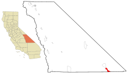
Location in Inyo County and the state of California
|
|
| Country | United States |
| State | California |
| County | Inyo |
| Area | |
| • Total | 18.657 sq mi (48.323 km2) |
| • Land | 18.589 sq mi (48.146 km2) |
| • Water | 0.068 sq mi (0.177 km2) 0.37% |
| Elevation | 1,545 ft (471 m) |
| Population
(2020)
|
|
| • Total | 120 |
| • Density | 6.43/sq mi (2.48/km2) |
| Time zone | UTC-8 (Pacific (PST)) |
| • Summer (DST) | UTC-7 (PDT) |
| ZIP code |
92389
|
| Area codes | 442/760 |
| FIPS code | 06-78050 |
| GNIS feature ID | 2410062 |

Tecopa is a small community in the Mojave Desert in southeast Inyo County, California, United States. It is known as a census-designated place (CDP), which means it's a special area defined by the government for collecting information. Long ago, Native American tribes like the Koso and Chemehuevi lived here. Later, in the late 1800s, pioneers came to support nearby mines. Today, Tecopa is famous for its natural hot springs.
Contents
Exploring Tecopa's Past
Early Trails and Settlements
The Old Spanish Trail was an important path for trade. Later, a wagon road called the Old Mormon Road also passed through this area. These trails went near what is now Tecopa. They followed the Amargosa River south to Salt Springs.
A place called China Ranch Wash is named after a Chinese man. Around 1900, he started a farm there. He grew food and raised animals to sell to the miners nearby.
How Tecopa Began
In 1875, two brothers, William D. and Robert D. Brown, found valuable lead and silver ore. This discovery led to the creation of the Resting Springs Mining District. They started a town called Brownsville. It was about 5 miles (8 km) southeast of Resting Springs.
A mining camp grew at this spot in the late 1870s. Jonas Osborne later bought out the Brown brothers. He renamed the town after a Paiute leader, Chief Tecopa. In 1877, the town even got its own post office.
Changes and New Beginnings
In 1878, it was decided that Tecopa was part of Inyo County. This settled a disagreement with San Bernardino County. Soon after, the town started to shrink. Most miners moved to Resting Springs in July 1879. The original townsite was sometimes used but never fully recovered. Today, a group called the Amargosa Conservancy helps protect this historic area.
The town was re-established in 1907. This happened when the Tonopah and Tidewater Railroad reached the area. This spot was the closest the railroad got to the mines. A new post office opened in 1907. Today, you can find a church, homes, and places to eat near this area, often called "The Triangle."
Tecopa's Hot Springs
North of "The Triangle" are the famous Hot Springs. In 1927, the State of California set aside land here. They later sold parts of it to people.
The Bureau of Land Management (BLM) gave Inyo County a special lease. This allowed the county to build facilities for the public. Today, the Hot Springs area has the Community Center, Fire Station, and Library. Many tourist places and homes are also located here.
Tecopa Heights Community
"The Triangle" is the western end of the Old Spanish Trail. If you head east, you pass the Tecopa-Francis Elementary School (which is now closed). Southwest of this area is the most populated part of Tecopa. It was once known as "Jackrabbit Flat."
In the 1950s, the government started offering small plots of land. These were meant for recreation or homes for people retiring. This area became known as "Tecopa Heights." The cemetery is on the west side of Tecopa Heights.
Tecopa does not have a big water system. So, in 2014, the local fire department got a grant. They used it to install a water kiosk for the community. This water kiosk opened in 2017.
Tecopa's Natural Surroundings
In 1976, the government protected the federal lands in Tecopa. They became part of the "California Desert Conservation Area." Tecopa is on the east side of the Amargosa Range. This mountain range is between Tecopa and Death Valley. Death Valley became a National Park in 1994. To the east of Tecopa is the Nopah Range, which is a protected wilderness area.
Tecopa covers about 18.7 square miles (48.3 square kilometers). Most of this area is land, with a small amount of water.
What Tecopa Offers
Economy and Attractions
In the past, Tecopa's economy was mostly about mining for silver and lead.
A popular spot today is the Tecopa Ecological Reserve. It has a natural hot spring that is not developed. However, sometimes this hot spring might be closed. This is to protect the Amargosa vole, a small rodent that lives there.
Tecopa also has a growing number of small breweries and bakeries. These places are popular with visitors to Tecopa's three hot springs resorts. They are especially busy during the fall and winter.
Fun Events and Culture
Tecopa hosts an annual "firehouse fling" every November. The Southern Inyo Fire Protection District puts on this event. It helps them raise money for the local fire department.
Since 2014, Tecopa has also hosted the Tecopa Takeover Music Festival. This music festival also takes place in November.
People of Tecopa
Population in 2010
In 2010, Tecopa had a population of 150 people. This means there were about 8 people living in each square mile (3.1 people per square kilometer). Most of the people were White (79.3%). There were also Native American, African American, and Asian residents. About 5.3% of the people were Hispanic or Latino.
There were 92 households in Tecopa. About 14.1% of these households had children under 18. Many households (60.9%) had only one person living there. About 30.4% of households had someone living alone who was 65 or older. The average household had 1.63 people.
The ages of people in Tecopa varied. About 12.7% were under 18. Many people (39.3%) were between 45 and 64 years old. A large group (33.3%) were 65 or older. The average age was 57.5 years.
Population in 2000
In 2000, there were 99 people living in Tecopa. There were 60 households and 22 families. The population density was about 5.3 people per square mile (2.1 people per square kilometer). Most people (88.89%) were White.
About 10.0% of households had children under 18. Many households (55.0%) had only one person. About 30.0% of these single-person households were people aged 65 or older. The average household had 1.65 people.
The average age in 2000 was 63 years. A significant portion of the population (43.4%) was 65 or older.
Community Services
Getting Around
Public transportation in Tecopa is provided by the Eastern Sierra Transit Authority. This service helps residents get to Pahrump twice a month. This is an important service for the community.
Utilities and Connections
Tecopa gets its electricity from Southern California Edison. There is no natural gas service in Tecopa. Instead, homes and businesses use propane gas, which is delivered from companies in Pahrump.
The main phone company for Tecopa is AT&T. However, the county has noted that phone and internet service can be unreliable. Because of this, many people in Tecopa use wireless internet providers or satellite internet.
Tecopa does not have regular trash pickup services for homes. Instead, residents use shared dumpsters. These dumpsters are emptied by a company called C&S Waste Solutions.
See also
 In Spanish: Tecopa para niños
 | James B. Knighten |
 | Azellia White |
 | Willa Brown |


