Amargosa Desert facts for kids
Quick facts for kids Amargosa Desert |
|
|---|---|

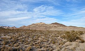
Amargosa Desert near the Bullfrog Hills
|
|

The Amargosa Desert is near Death Valley
|
|
| Floor elevation | 2,411 ft (735 m) |
| Area | 2,600 sq mi (6,700 km2) |
| Geography | |
| Country | United States |
| State | Nevada and California |
| Region | Great Basin |
| County | Nye and Inyo |
| Borders on | west: Funeral Mountains & Yucca Mountain east: Nellis Air Force Range |
| River | Amargosa |
The Amargosa Desert is a dry, open area mostly in Nye County, Nevada, United States. It sits right along the border with California. This desert is part of the larger Amargosa Valley, located north of the Ash Meadows National Wildlife Refuge.
The desert gets its name from the Amargosa River. The word "Amargosa" comes from Spanish and means "bitter." This is because the river's water has a bitter taste.
Contents
Geography of the Amargosa Desert
The Amargosa Desert is located at an elevation of about 2,600 to 2,750 feet (790 to 840 m) above sea level. It includes an area called Crater Flat and the town of Amargosa Valley, Nevada, which used to be known as Lathrop Wells. This town is at the southern end of the desert.
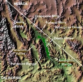
The desert is surrounded by mountains and other important areas. To the west, you'll find the Funeral Mountains and Death Valley. To the east, there's Yucca Mountain and the Nellis Air Force Range.
Nature and Wildlife in the Amargosa Desert
The Amargosa Desert is a very dry place, known as an arid desert habitat. It's a special area where two different natural regions meet: the northern Great Basin and the southern Mojave Desert. This makes it a unique place for plants and animals.
The Amargosa River flows through the desert, but only during certain seasons. In the nearby Ash Meadows National Wildlife Refuge, you can find the rare Shoshone pupfish. This fish lives in the Desert National Wildlife Refuge Complex.
History of the Amargosa Desert
Ancient Times in the Amargosa Desert
We don't know exactly when the first people lived in the Amargosa Desert. However, ancient campsites have been found that are at least 10,000 years old. These date back to the end of the last ice age. Recent studies of old remains suggest that more people lived here long ago than we first thought.
Pottery and other items have been discovered that are from about 1000 A.D. and even earlier. In the 1800s, two groups of Native Americans lived in the Amargosa Valley. These were the Southern Paiute and the Western Shoshone people. They were very skilled at finding food and resources in this tough desert environment. They ate wild plants and hunted wild animals.
European Exploration and Mining History
The first town in the Amargosa Desert was started around 1905. This happened because a lot of borax was being mined in the area. Borax is a mineral used in many products.
By 1907, two railroads were built to help with mining. They carried borax, gold, silver, lead, and other important minerals. The Tonopah and Tidewater Railroad (T and T) connected Ludlow, California to Gold Center, near Beatty. The other railroad, the Las Vegas and Tonopah Railroad, linked Las Vegas to Goldfield, Nevada.
Over time, as mining changed, the railroads became less useful. The Las Vegas and Tonopah line closed in 1918. The T and T shut down on June 14, 1940. By 1942, all the T and T's rails were taken to help the U.S. Department of War during World War II. Today, only parts of the old railroad paths remain. The U.S. Bureau of Land Management (BLM) uses some of these paths for hiking trails in California.
Modern Development and Yucca Mountain
Modern growth in the Amargosa Valley didn't really start until the early 1950s. Electricity from a power company wasn't available until 1963. Before the early 1990s, the area grew very slowly. More recently, because Las Vegas has grown so much, many new people have moved to Amargosa Valley and nearby Pahrump.
The Amargosa Valley is close to the Yucca Mountain Repository. This is a place on federal land that the U.S. Department of Energy (DOE) planned to use for storing high-level nuclear waste. In 2002, President George W. Bush approved building the facility. The main entrance was planned to be about 14 miles (23 km) south of the storage tunnels. However, in 2009, President Barack Obama said that Yucca Mountain was no longer being considered for storing nuclear waste.
Solar Power in Amargosa Valley
The Amargosa Farm Road Solar Project was a plan for a large solar power plant. It was designed to produce 500 megawatts of electricity. The project was first planned to use a special type of solar technology, but then it changed to use photovoltaic (PV) technology, which uses solar panels. The company behind it went bankrupt, and the project stopped. Later, in 2013, a smaller 65-megawatt PV plant was proposed for private land.
Climate of the Amargosa Desert
The Amargosa Valley has a mild desert climate. This means it has very hot summer days and mild winters. The hottest temperature ever recorded in Amargosa Valley was 118 °F (47.7 °C) on July 9, 2002. The coldest temperature was 6 °F (-14.4 °C) on December 22, 1990. On average, the area gets about 4.29 inches of rain each year.
Getting Around Amargosa Valley
The main roads in Amargosa Valley are U.S. Route 95 and State Route 373. U.S. Route 95 runs north and south, connecting Las Vegas and Reno. State Route 373 also runs north and south, linking Amargosa Valley to Death Valley Junction in California.
Fun Things to Do in Amargosa Valley
Ash Meadows National Wildlife Refuge
Ash Meadows National Wildlife Refuge is a special place with about 23,000 acres (93 km²) of wetlands fed by natural springs. The United States Fish and Wildlife Service manages this refuge. It's home to at least 24 types of plants and animals that are found nowhere else in the world!
Some of these unique species are listed as endangered species. These include four types of fish (like the Devil's Hole pupfish and Amargosa pupfish), one insect, and one plant. You can get to Ash Meadows National Wildlife Refuge from State Route 373 in Amargosa Valley. You can also reach it from State Route 160 near Crystal, Nevada or from Bell Vista Road west of Pahrump. Look for road signs that mark the entrances to the refuge.
Big Dune
Big Dune is a large group of sand dunes. The highest point of the dunes is about 300 feet (91 m) above the land around it. The BLM takes care of the dunes and the land around them. People can use this area for fun activities, including those with motorized vehicles and those without. You can get to Big Dune from Valley View Road, which is about 2.5 miles (4 km) south of U.S. 95.
See also
 In Spanish: Desierto de Amargosa para niños
 | Audre Lorde |
 | John Berry Meachum |
 | Ferdinand Lee Barnett |

