Amargosa Valley facts for kids
Quick facts for kids Amargosa Valley |
|
|---|---|

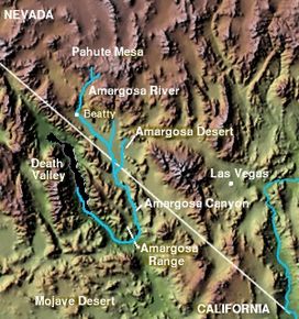
Course of the Amargosa River, depicting where it flows through the Amargosa Valley before entering the Amargosa Canyon
|
|
| Area | 900 sq mi (2,300 km2) |
| Geography | |
| Location | United States, Nevada |
The Amargosa Valley is a long valley in the southwestern Nevada and eastern California. It's where the Amargosa River flows south. The valley stretches from near Beatty, Nevada in the north to Tecopa, California in the south. At Tecopa, the river enters a narrow area called the Amargosa Canyon.
Contents
Geography of Amargosa Valley
The Amargosa Valley is part of a larger area called the Basin and Range Province. This region has many tall, narrow mountains and flat, dry valleys. The Amargosa Valley is long from north to south and narrow from east to west.
It sits to the east of Death Valley. The Amargosa Range and Funeral Mountains separate the two valleys. The Amargosa Valley is also located within the Mojave Desert. This is a very dry region.
History of Amargosa Valley
Early People in the Valley
We don't know exactly when the first people came to the Amargosa Desert. But ancient campsites have been found that are at least 10,000 years old. These date back to the end of the last ice age.
Scientists have found pottery and other items from about 1000 A.D. and even earlier. These discoveries show that ancient people used the valley more than we first thought.
In the 1800s, two main groups of Native Americans lived here. They were the Southern Paiute and the Western Shoshone. Both groups were very skilled at living in this dry environment. They found wild plants to eat and hunted wild animals for food.
European Explorers and Settlers
An old trading path called the Old Spanish Trail went through the southern part of the Amargosa Valley. Later, a wagon road called the Old Mormon Road also used this route. These trails helped people travel between different areas.
In 1849, a group of travelers headed for California. They wanted to avoid a dangerous mountain route. A guide named Captain Smith told them about a shorter path across the southern deserts. He showed them a map that seemed to promise water and grass for their wagons and animals.
However, this map was not completely accurate. It showed mountains that didn't exist in the middle of Nevada. This might have made the travelers think the new route would be easier.
A small group led by William L. Manly, James Brier, and Asahel Bennett decided to try this new path. They were experienced outdoorsmen. They soon found themselves in the Amargosa Desert.
After leaving Ash Meadows, they crossed the Amargosa range. They then went into Death Valley through Furnace Creek Wash. Their animals became too weak to pull the wagons. Two men, Manly and John Haney Rogers, went for help. They traveled about 500 miles across the desert to get supplies.
Four weeks later, Manly and Rogers returned with food and a mule. The Bennett and Arcane families then walked out of the valley. They named it "Death Valley" because of their difficult journey. Only one person from their group died within Death Valley itself.
Native Americans in the area knew about the struggles of these travelers. They could have helped them. But they often saw the white settlers as unkind.
Many of these travelers were hoping to find gold in California. However, the gold rush of 1849 was not as profitable as the later silver rush in Nevada.
Climate
The Amargosa Valley has a mild desert climate. This means it has very hot summer days. Winters are usually mild. The highest temperature ever recorded was 118 °F (47.7 °C) on July 9, 2002. The coldest was 6 °F (-14.4 °C) on December 22, 1990. On average, the valley gets about 4.29 inches of rain each year.
Transportation
The main roads in Amargosa Valley are U.S. Route 95 and State Route 373. U.S. Route 95 runs north and south, connecting Las Vegas and Reno. State Route 373 also runs north and south. It connects Amargosa Valley to Death Valley Junction.
Recreation
The Ash Meadows National Wildlife Refuge is a special place. It has about 23,000 acres of wetlands fed by natural springs. The United States Fish and Wildlife Service manages this refuge. It is home to at least 24 kinds of plants and animals found nowhere else in the world.
Some of these species are endangered. This means they are at risk of disappearing forever. Examples include four types of fish: the Devil's Hole Pupfish, Amargosa Pupfish, Warm Springs Pupfish, and Ash Meadows Speckled Dace. There is also an endangered insect called the Ash Meadows Naucorid and a plant called the Amargosa Niterwort. You can visit Ash Meadows NWR from State Route 373.
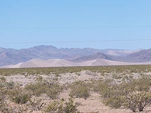
Big Dune is a large sand dune formation. It rises about 300 feet (91 meters) above the land around it. The BLM looks after Big Dune. People can use it for both motorized and non-motorized fun. You can reach Big Dune from Valley View Road, about 2.5 miles south of U.S. 95.
Tecopa Hot Springs offers places where you can relax in warm baths. These baths are filled with natural hot spring water.
See also
 In Spanish: Valle Amargosa para niños
 | Misty Copeland |
 | Raven Wilkinson |
 | Debra Austin |
 | Aesha Ash |


