
Nevada Test and Training Range facts for kids
Quick facts for kids Nevada Test and Training Range |
|
|---|---|
| Part of Nellis Air Force Base Complex | |
| Nye and Lincoln counties, Nevada Near Las Vegas in US |
|
 |
|

"Nellis Air Force Range" and nearby federal lands
|
|
| Coordinates | 37°31′36″N 116°11′53″W / 37.52667°N 116.19806°W |
| Area | Land: 4,531 sq mi (11,740 km2) in 2012 Airspace: 5,000 sq mi (13,000 km2) restricted, 7,000 sq mi (18,000 km2) shared (MOA) |
| Site information | |
| Owner | Department of Defense |
| Site history | |
| Built | established September 29, 1940 |
| Garrison information | |
| Occupants | 2011: NTTR military unit 2001: 98th Range Wing
1948: ATC Flying Division |
The Nevada Test and Training Range (NTTR) is a huge military training area in Nevada. It's part of the Nellis Air Force Base Complex. The United States Air Force Warfare Center uses it for many important training missions.
The NTTR covers a massive land area. It has a "simulated Integrated Air Defense System." This system helps pilots practice against enemy defenses. There are also 1,200 targets for bombing and gunnery practice. Plus, it has four remote communication sites.
Over the years, the NTTR has been used for many things. These include aerial gunnery, bombing, and even nuclear tests. It's also a place for testing new aircraft. Today, it hosts large-scale training exercises like Blue Flag, Green Flag, and Red Flag exercises.
Exploring the NTTR's Unique Geography
The Nevada Test and Training Range is mostly a desert area. It's part of the Great Basin Desert. You can find many unique landforms here. These include mountains and valleys.
Key Landforms and Their Uses
The NTTR is located in southern Nevada. It uses many natural features for military operations. For example, Groom Lake is an airstrip near the NTTR's northeast border. It's famous for Area 51.
Other important spots include Tolicha Peak and Point Bravo. These are used for electronic combat training. Mercury Valley is another area. It's named after a Cold War camp that became the town of Mercury.
The Tonopah Test Range is also inside the NTTR. It includes places like Antelope Lake and Radar Hill.
Northern Training Areas
The Northern Range is a key part of the NTTR. It includes the Tolicha Peak Electronic Combat Range (TPECR). This area has many targets for training. The Tonopah Electronic Combat Range is also here.
Eastman Airfield Training Target
The Eastman Airfield Target is a special training area. It looks like a former Soviet Air Force base. This helps pilots practice against realistic enemy airfields. It even has fake hangars and taxiways.
There are also two simulated SAM sites nearby. This makes the training even more realistic.
Southern Training Areas
The Southern Range includes the Point Bravo Electronic Combat Range. A large part of this area is shared. The Air Force and the USFWS manage it together. This helps protect wildlife while allowing training.
Neighboring Military Facilities
Besides Nellis AFB, other areas are used for related activities. Some former military lands are now under "Area A" airspace. This is a Military Operations Area (MOA).
Other nearby areas are managed by the Bureau of Land Management. These lands are used for things like grazing. Temporary sites are also set up for exercises. These sites are used for mobile electronic equipment.
A Look at the NTTR's History
The land where the NTTR sits has a long history. It was formed by ancient lava flows and faults. The area was once home to Great Basin tribes. The Old Spanish Trail (trade route) also crossed through this region.
In the 1930s, the land was a wildlife reservation. But in 1942, during World War II, the area became restricted. The War Department needed it for military use. The region had been used for silver mining in the early 1900s.
The area was later divided into smaller sections. These sections are still used today. For example, Area 51 is known as "Groom Lake Field."
The Early Bombing Ranges
The Tonopah Bombing Range was created in 1940. In 1941, it was split into two parts. These were the "Tonopah General Range" and the "Las Vegas General Range."
In 1942, the Fourth Air Force arrived. They set up several airfields for training. These included the Tonopah Army Air Field and Indian Springs Auxiliary Army Airfield. Pilots practiced air-to-air gunnery here.
In 1949, the Las Vegas Bombing and Gunnery Range and the Tonopah Bombing and Gunnery Range were combined. The land was perfect for training. It was far from people and had dry lake beds for target practice.
Becoming the Nellis Air Force Gunnery and Bombing Range
A part of the range became the Nevada Proving Grounds (NPG) in 1950. This new area included places like Yucca Flat and Frenchman Flat. The first nuclear test at the NPG happened in 1951.
Indian Springs Auxiliary Army Airfield (later Creech Air Force Base) supported these tests. In 1955, a runway was built at Groom Lake for Project AQUATONE. This project involved testing the secret U-2 spy plane.
The Tonopah Test Range (TTR) was also created in 1956. It was used for nuclear test sites. From 1956 to 1970, radar stations helped track flights over the range.
In 1975, the first Red Flag exercise took place at Nellis. This exercise trains pilots in realistic combat situations.
The Nellis Air Force Range Era
The Nellis Air Force Range (NAFR) was used for many purposes. It was a site for burying wreckage from aircraft crashes. It also saw several accidents during the Cold War.
Around 1980, the NAFR received new systems. These systems simulated enemy electronic warfare. From 1983 to 1985, the range was used for testing Tomahawk missiles.
In 1999, the range's land use was renewed. The unused parts of the original Tonopah Bombing Range were renamed. They became a Formerly Used Defense Site.
In 2001, the NAFR was renamed the Nevada Test and Training Range (NTTR). In 2005, Indian Springs AFAF became Creech Air Force Base. The Nevada Test Site was renamed the Nevada National Security Site in 2010.
The Area 51 Facebook Event
In 2019, a funny Facebook event went viral. It called for people to "storm" the training range. The idea was to "see them aliens." Over two million people said they would go.
Air Force officials warned people not to come. They said the area is an "open training range." They also stated that the U.S. Air Force is ready to protect its assets.
Images for kids
-
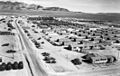
Camp Desert Rock, a military support facility.

