Long Valley Caldera facts for kids
Quick facts for kids Long Valley Caldera |
|
|---|---|
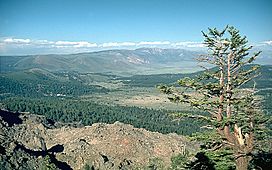
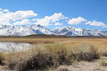
View from northeast rim of caldera
|
|
| Floor elevation | 6,500–8,500 ft (2,000–2,600 m) |
| Length | 20 mi (32 km) EW |
| Width | 11 mi (18 km) |
| Depth | up to 3,000 ft (900 m) |
| Geology | |
| Type | Caldera |
| Age | 760,000 yrs |
| Geography | |
| Location | Mono County, California United States |
The Long Valley Caldera is a huge bowl-shaped depression in eastern California. It sits right next to Mammoth Mountain. This valley is one of the biggest calderas on Earth. It is about 20 miles (32 km) long from east to west and 11 miles (18 km) wide from north to south. It can be up to 3,000 feet (914 m) deep.
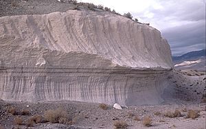
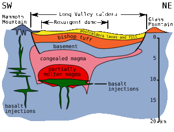
Long Valley was created 760,000 years ago by a very big volcanic eruption. This eruption sent out hot ash that later cooled. This cooled ash formed a rock called Bishop tuff, which is common in the area. The eruption emptied a large magma chamber underground, causing the land above it to collapse. This collapse created the caldera. The eruption also sent out fast-moving flows of hot gas and ash, called pyroclastic flows. These flows burned and buried thousands of square miles. Ash from this eruption covered much of the western part of what is now the United States.
Contents
Geography of Long Valley
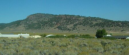
The caldera is like a giant bowl. It is about 20 miles (32 km) long. Mountains surround it on most sides, except to the southeast. The bottom of the bowl is between 6,500 and 8,500 feet (1,981 to 2,591 m) high. It is higher in the western part.
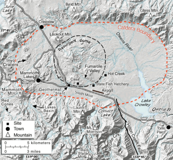
Near the middle of the bowl, rising magma has pushed up the ground. This created a hill called a resurgent dome. The southeastern slope of the caldera, heading towards Bishop, is covered with Bishop Tuff. This is the solidified ash from the eruption that made the caldera. The Bishop Tuff is 1,500 meters (4,921 ft) thick on the caldera floor. The Owens River Gorge cuts through it. This gorge formed when the caldera filled with water long ago and overflowed.
The edge of the caldera is made of older rock. It rises about 3,000 feet (914 m) above the caldera floor. However, the eastern edge is lower, only about 500 feet (152 m) high.
Mammoth Mountain is a group of lava domes located west of the caldera's edge. It has about 12 overlapping domes made of rhyodacite and dacite. These domes formed from many eruptions between 110,000 and 57,000 years ago. They built a volcano that is 11,059 feet (3,371 m) tall.
The Mono–Inyo Craters are a 25-mile (40 km) long chain of volcanoes. They stretch along the western edge of the caldera, from Mammoth Mountain to Mono Lake. The Mono-Inyo Craters erupted from 40,000 to 600 years ago. Their magma source was separate from the Long Valley Caldera.
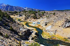
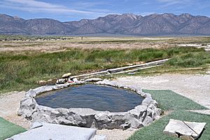
The caldera has many hot springs and steam vents. Casa Diablo Hot Springs, at the base of the resurgent dome, has a geothermal power plant. This plant uses the Earth's heat to make electricity. Hot Creek flows through hot springs. The warm water in Hot Creek helps many trout grow. It is also used at the Hot Creek Fish Hatchery. In 2006, Hot Creek was closed for swimming because geothermal activity in the area increased. Other hot springs in the area are open for people to bathe in.
Geology of the Caldera
The reasons for the volcanoes in Long Valley are still being studied. Long Valley is not above a hotspot, like Yellowstone Caldera. It is also not caused by subduction, which creates volcanoes like those in the Cascades.
The volcanic history of Long Valley Caldera began millions of years ago. Magma started to gather several miles below the surface. Volcanic activity became strong in the Long Valley area about 3.1 to 2.5 million years ago. This included eruptions of rhyodacite and later high-silica rhyolite. Over time, many rhyolitic volcanoes formed here. About 1,500 square miles (3,885 sq km) were covered by lava.
Most of these volcanoes were destroyed by a huge eruption 760,000 years ago. This eruption was a VEI-7 event. It released 600 cubic kilometers (144 cubic miles) of material. To compare, the 1980 Mount St. Helens eruption was a VEI-5 and released 1.2 cubic kilometers (0.29 cubic miles). About half of the material from Long Valley was ejected as very hot (1,500°F or 816°C) pyroclastic flows. These flows were a mix of gases, pumice, and volcanic ash. They covered the surrounding area hundreds of feet deep. Some of this material flowed south into Owens Valley. Other parts moved west over the Sierra Nevada mountains. The rest of the ash was blown 25 miles (40 km) into the air. Winds carried it as far as eastern Nebraska and Kansas.
The eruption first created a caldera that was 2 to 3 kilometers (1.2 to 1.9 mi) deep. However, much of the ejected material fell back down. This filled the caldera about two-thirds full.
Later Eruptions
After the big eruption, later eruptions happened inside the caldera. Hot, crystal-free rhyolite erupted from 700,000 to 600,000 years ago. This caused the caldera floor to uplift and form the resurgent dome. Cooler, crystal-rich rhyolite then erupted every 200,000 years. This happened 500,000, 300,000, and 100,000 years ago. The volcanic activity has been decreasing over the last 650,000 years. This suggests that the magma under the caldera has mostly turned solid. It is unlikely to cause very large eruptions in the future.
The Long Valley volcano is special because it has produced both basaltic (dark, fluid) and silicic (light, thick) lava in the same place.
Water from the Owens River filled the caldera to a depth of 300 meters (984 ft) about 600,000 years ago. This formed a large lake. The lake drained sometime in the last 100,000 years. It overflowed the southern rim of the caldera and created the Owens River Gorge. Today, a human-made dam in the gorge has created Crowley Lake. This lake partly restores the original ancient lake. Since the great eruption, many hot springs have formed. The resurgent dome has also continued to uplift.
During the last ice age, glaciers filled the canyons leading to Long Valley. However, the valley floor itself was clear of ice. You can still see great examples of terminal moraines (piles of rock left by glaciers) at Long Valley. Laurel Creek, Convict Creek, and McGee Creek all have clear moraines.
Recent Activity and Monitoring
In May 1980, a strong series of earthquakes hit the southern edge of the Long Valley Caldera. This included four earthquakes that were Richter magnitude 6. At the same time, the caldera floor uplifted by 10 inches (25 cm), forming a dome shape. These events started a period of unrest in the caldera that is still happening. This unrest includes repeated earthquake swarms and continued uplift of the caldera's center. There are also changes in hot springs and gas emissions. After the 1980 quakes, a new road was built as a possible escape route for the town of Mammoth Lakes. It was first called the "Mammoth Escape Route." But its name was changed to the Mammoth Scenic Loop after local businesses complained.
In 1982, the United States Geological Survey (USGS) started to closely watch and study the Long Valley Caldera. Their goal is to give people and local authorities good information about possible dangers. They also want to give early warnings if a volcanic eruption might happen. Most volcanic eruptions are preceded by changes in the volcano. Common signs include more earthquakes, ground changes, and different gas emissions.
Hot Springs and Water Flow
The Long Valley Caldera has an active system of hot water. This includes hot springs, fumaroles (steam vents), and mineral deposits. Hot springs are mostly in the eastern half of the caldera, where the land is lower. Fumaroles are mostly in the western half, where the land is higher. Mineral deposits from hot water activity are found on the resurgent dome. They are also at Little Hot Creek springs, Hot Creek Gorge, and other places.
Hot springs mainly release water in Hot Creek Gorge, along Little Hot Creek, and in the Alkali Lakes area. The biggest springs are in Hot Creek Gorge. About 250 liters (66 gallons) per second of hot water flow out there. This is about 80% of all the hot water released in the caldera. At the other end, springs at Hot Creek Fish Hatchery have a small amount (2–5%) of hot water. This raises the water temperature by about 5°C (9°F). Using this warm water in the hatchery helps fish grow faster than in cold stream water.
In areas with hot springs, water moves underground because of the land's shape and heat sources. In Long Valley Caldera, water mostly comes from snowmelt in the high areas around the caldera's edges. This snowmelt and rainfall sinks deep into the ground, a few kilometers down. There, hot rocks heat the water to at least 220°C (428°F). The heated water then rises in the western part of the caldera. It flows along steep cracks. This hot water then moves sideways, from west to southeast, around the resurgent dome. It then flows eastward to places like Hot Creek and Crowley Lake. The water temperature drops from 220°C (428°F) near the Inyo Craters to 50°C (122°F) near Crowley Lake. This happens because the water loses heat and mixes with cold water.
Hot Creek has been a popular swimming spot for many years. However, more than a dozen people have died there since the late 1960s. Most of these deaths happened when people ignored warning signs. They tried to use the very hot pools as hot tubs. These pools can have sudden bursts of super-heated water. Because of recent geothermal changes, Hot Creek is currently closed for swimming. Officials are not sure when, or if, it will officially reopen.
Hot water activity has changed many rocks in the caldera. It has turned them into travertine and clay. At the Huntley clay mine, a white chalky clay called kaolinite is mined. This kaolinite is visible on the resurgent dome as a bright white band.
Things to Do and See
The biggest attraction in the caldera is the Mammoth Mountain Ski Area. Here, you can go skiing and snowboarding in winter. In summer, you can enjoy mountain biking. The Hot Creek tourist spot was closed for swimming in 2006 due to more geothermal activity.
You can go Hiking and off-road vehicle driving throughout the caldera. You can also explore the glacial valleys of the Sherwin Range, just south of the caldera. Hikers can reach several lakes in these valleys. These include Valentine Lake, Convict Lake, Lake Dorothy, and Laurel Lakes. Crowley Lake, at the south end of the caldera, is famous for its fishing.
The closest places to stay are hotels in Mammoth Lakes. There are also many campgrounds scattered around the caldera and in the nearby mountains.
Safety and Fatalities
In April 2006, three members of the Mammoth Mountain Ski Area ski patrol died while working. They died from breathing in carbon dioxide gas. This happened when they fell into a fumarole (a steam vent) on the mountain slopes. They were trying to put a fence around it.
See also
 In Spanish: Long Valley Caldera para niños
- List of large volume volcanic eruptions in the Basin and Range Province
- Glass Mountain
- Map of Long Valley-Mono area
- Mono–Inyo Craters
- Mammoth Geothermal Complex - a geothermal power plant in the area
 | George Robert Carruthers |
 | Patricia Bath |
 | Jan Ernst Matzeliger |
 | Alexander Miles |


