Furnace Creek, California facts for kids
Quick facts for kids
Furnace Creek, California
|
|
|---|---|

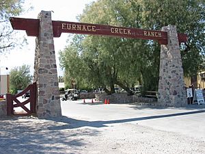
Entrance to Furnace Creek Ranch
|
|

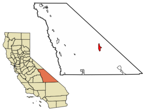
Location in Inyo County and the state of California
|
|
| Country | United States |
| State | California |
| County | Inyo |
| Area | |
| • Total | 31.463 sq mi (81.487 km2) |
| • Land | 31.203 sq mi (80.815 km2) |
| • Water | 0.260 sq mi (0.672 km2) 0.82% |
| Elevation | -226 ft (−68.9 m) |
| Population
(2020)
|
|
| • Total | 136 |
| • Density | 4.323/sq mi (1.669/km2) |
| Time zone | UTC−08:00 (Pacific (PST)) |
| • Summer (DST) | UTC−07:00 (PDT) |
| ZIP Code |
92328
|
| Area codes | 442/760 |
| FIPS code | 06-28021 |
| GNIS feature ID | 2408270 |
Furnace Creek, once called Greenland Ranch, is a small community in Inyo County, California. It is known as a census-designated place (CDP). In 2020, 136 people lived there, which was a big jump from 24 people in 2010.
This village is special because it is 190 feet (58 m) below sea level. It is one of the lowest places on land. Furnace Creek is also home to the main visitor center, museum, and offices for Death Valley National Park.
Contents
History of Furnace Creek
The area now known as Furnace Creek was first settled in 1883. Two businessmen, Francis Marion Smith and William Tell Coleman, started a company called the Harmony Borax Works. They created Greenland Ranch, named for the green alfalfa fields they planted.
In 1891, a weather station was set up at the ranch. Later, in 1933, Greenland Ranch was renamed Furnace Creek Ranch.
The Timbisha Tribe and Borax Mining
The Timbisha tribe lives on a reservation in Furnace Creek today. They helped build many of the original buildings for the Fred Harvey Company resort and the Park Service. Most of the people living in Furnace Creek are members of the Timbisha tribe.
Furnace Creek was once a very important place for mining in Death Valley. The Pacific Coast Borax Company used to mine borax here. They used famous "20-Mule Teams" to pull wagons full of borax across the Mojave Desert.
Geography of Furnace Creek
Furnace Creek covers about 31.5 square miles (82 km2) of land. Almost all of this area is dry land.
There used to be natural springs in the Amargosa Range that created an oasis at Furnace Creek. An oasis is a green area in a desert where water is found. However, much of this water has been used to support the village, so the oasis has become smaller over time.
Climate and Temperatures
Furnace Creek, like the rest of Death Valley, has a very hot desert climate. This means it has long, extremely hot summers and short, warm winters. There is also very little rain.
- Summer Heat: Daytime temperatures in July can reach around 116 °F (47 °C). Nights are also warm, often staying around 90 °F (32 °C).
- Winter Warmth: In December, daytime temperatures are usually around 65 °F (18 °C). Nights can drop to about 40 °F (4 °C).
From 1911 to 2006, the average high temperature was 91.4 °F (33.0 °C). July was the hottest month, with an average daily high of 116.5 °F (46.9 °C). June was the driest month, with almost no rain.
Furnace Creek holds some amazing weather records:
- It had 43 days in a row with temperatures above 120 °F (49 °C) in 1917.
- The average temperature in July 2018 was 108.1 °F (42.3 °C). This is the highest average temperature for any month, anywhere in the world!
- On July 10, 1913, Furnace Creek recorded the highest air temperature ever: 134 °F (56.7 °C). Some weather experts question if this measurement was perfectly accurate.
- On July 15, 1972, the ground temperature reached 201 °F (94 °C). This might be the highest natural ground temperature ever recorded! Ground temperatures can be much hotter than the air.
| Climate data for Furnace Creek, Death Valley, California (1991–2020 normals, extremes 1911–present). Elevation: −190 ft (−58 m). | |||||||||||||
|---|---|---|---|---|---|---|---|---|---|---|---|---|---|
| Month | Jan | Feb | Mar | Apr | May | Jun | Jul | Aug | Sep | Oct | Nov | Dec | Year |
| Record high °F (°C) | 90 (32) |
102 (39) |
108 (42) |
113 (45) |
122 (50) |
129.2 (54.0) |
134.1 (56.7) |
130 (54) |
127 (53) |
118 (48) |
98 (37) |
89 (32) |
134.1 (56.7) |
| Mean maximum °F (°C) | 78.4 (25.8) |
85.1 (29.5) |
95.4 (35.2) |
106.0 (41.1) |
113.6 (45.3) |
122.0 (50.0) |
125.9 (52.2) |
123.4 (50.8) |
118.1 (47.8) |
106.2 (41.2) |
90.0 (32.2) |
77.8 (25.4) |
126.7 (52.6) |
| Mean daily maximum °F (°C) | 67.2 (19.6) |
73.7 (23.2) |
82.6 (28.1) |
91.0 (32.8) |
100.7 (38.2) |
111.1 (43.9) |
117.4 (47.4) |
115.9 (46.6) |
107.7 (42.1) |
93.3 (34.1) |
77.4 (25.2) |
65.6 (18.7) |
92.0 (33.3) |
| Daily mean °F (°C) | 54.9 (12.7) |
61.3 (16.3) |
69.8 (21.0) |
77.9 (25.5) |
87.8 (31.0) |
97.5 (36.4) |
104.2 (40.1) |
102.3 (39.1) |
93.4 (34.1) |
78.9 (26.1) |
64.0 (17.8) |
53.4 (11.9) |
78.8 (26.0) |
| Mean daily minimum °F (°C) | 42.5 (5.8) |
49.0 (9.4) |
57.1 (13.9) |
64.8 (18.2) |
75.0 (23.9) |
84.0 (28.9) |
91.0 (32.8) |
88.7 (31.5) |
79.1 (26.2) |
64.4 (18.0) |
50.5 (10.3) |
41.1 (5.1) |
65.6 (18.7) |
| Mean minimum °F (°C) | 30.5 (−0.8) |
36.1 (2.3) |
42.8 (6.0) |
49.8 (9.9) |
58.5 (14.7) |
67.9 (19.9) |
78.3 (25.7) |
75.3 (24.1) |
65.4 (18.6) |
49.5 (9.7) |
35.9 (2.2) |
29.0 (−1.7) |
28.0 (−2.2) |
| Record low °F (°C) | 15 (−9) |
20 (−7) |
26 (−3) |
35 (2) |
42 (6) |
49 (9) |
62 (17) |
65 (18) |
41 (5) |
32 (0) |
24 (−4) |
19 (−7) |
15 (−9) |
| Average precipitation inches (mm) | 0.37 (9.4) |
0.52 (13) |
0.25 (6.4) |
0.10 (2.5) |
0.03 (0.76) |
0.05 (1.3) |
0.10 (2.5) |
0.10 (2.5) |
0.20 (5.1) |
0.12 (3.0) |
0.10 (2.5) |
0.26 (6.6) |
2.20 (56) |
| Average precipitation days (≥ 0.01 in) | 2.4 | 2.9 | 2.0 | 1.1 | 0.9 | 0.3 | 1.1 | 0.9 | 0.8 | 1.1 | 0.9 | 1.6 | 16.0 |
| Mean monthly sunshine hours | 217 | 226 | 279 | 330 | 372 | 390 | 403 | 372 | 330 | 310 | 210 | 186 | 3,625 |
| Source: NOAA | |||||||||||||
Population of Furnace Creek
| Historical population | |||
|---|---|---|---|
| Census | Pop. | %± | |
| 2000 | 31 | — | |
| 2010 | 24 | −22.6% | |
| 2020 | 136 | 466.7% | |
| U.S. Decennial Census | |||
In 2010, Furnace Creek had a population of 24 people. This meant there were about 0.8 people living per square mile.
Most of the people living there were Native American (66.7%). A smaller number were White (25.0%), and some were from two or more races (8.3%). All 24 people lived in homes.
Things to Do in Furnace Creek
Furnace Creek is a popular spot for tourists visiting Death Valley.
- Camping: There are many public campgrounds run by the National Park Service around the village.
- The Ranch at Death Valley: This is a major place for visitors to stay. It is part of the Oasis at Death Valley.
- Golf: The Furnace Creek Golf Course is connected to The Ranch. It is the lowest golf course in the world, at 214 feet (65 m) below sea level. Even when it's super hot in summer (over 125 °F (52 °C)), the golf course stays open. They even have a "Heatstroke Open" tournament in the summer!
- Services: In Furnace Creek village, you can find a restaurant, a café, a store, and a gas station.
- Airport: The Furnace Creek Airport is located about 0.75 miles (1.21 km) west of the park headquarters.
California Historical Landmark
Near Furnace Creek, you can find California Historical Landmark number 442. This landmark is called the Death Valley '49ers Gateway. It was given this special status on October 24, 1949. You can find the marker where State Route 190 and Badwater Road meet.
The landmark tells a story about a group of pioneers:
- NO. 442 DEATH VALLEY GATEWAY - This was the natural entrance for the Death Valley '49ers. These were more than 100 travelers from the Midwest who were trying to find a shortcut to the gold fields in central California. They entered Death Valley in December 1849. Everyone suffered from not having enough water and food.
- To escape the area, some groups went southwest from here, while others went northwest.
These travelers are the ones who are said to have given Death Valley its famous name.
See also
 In Spanish: Furnace Creek para niños
 | Kyle Baker |
 | Joseph Yoakum |
 | Laura Wheeler Waring |
 | Henry Ossawa Tanner |


