Olancha, California facts for kids
Quick facts for kids
Olancha
|
|
|---|---|

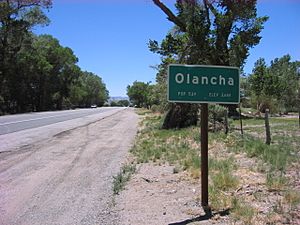
Entrance sign, southbound
|
|

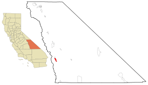
Location in Inyo County and the state of California
|
|
| Country | |
| State | |
| County | Inyo |
| Area | |
| • Total | 7.872 sq mi (20.388 km2) |
| • Land | 7.841 sq mi (20.308 km2) |
| • Water | 0.031 sq mi (0.080 km2) 0.39% |
| Elevation | 3,698 ft (1,127 m) |
| Population
(2020)
|
|
| • Total | 131 |
| Time zone | UTC-8 (Pacific) |
| • Summer (DST) | UTC-7 (PDT) |
| ZIP code |
93549
|
| Area codes | 442/760 |
| FIPS code | 06-53490 |
| GNIS feature ID | 2408982 |
| Official name: Farley's Olancha Mill Site | |
| Reference #: | 796 |
Olancha is a small community in Inyo County, California. It is located on U.S. Route 395 in California, about 37 miles (60 km) south of Independence. In 2020, the population was 131 people.
Olancha is found in the Owens Valley, right next to Owens Lake, which is mostly dry now. This desert-like area is home to a big bottled water plant for Crystal Geyser Natural Alpine Spring Water. The name "Olancha" might come from the nearby Yaudanche tribe.
Contents
Geography of Olancha
Olancha is an unincorporated community in the Owens Valley. It sits on the eastern side of the Sierra Nevada mountain range. The town is about 3,650 feet (1,113 meters) above sea level.
You can find Olancha on Highway 395, close to where State Route 190 joins it. It is about 200 miles (320 km) north of Los Angeles. The dry Owens Lake is to the northeast of Olancha.
Olancha Creek flows from the slopes of nearby Olancha Peak, which is 12,123 feet (3,695 meters) tall. The creek passes near the town and flows towards Owens Lake. East of Olancha, there are sand dunes and a hot spring called "Dirty Socks."
The area of Olancha covers about 7.9 square miles (20.5 square kilometers). Almost all of this area is land.
Olancha's Climate
Olancha has a semi-arid climate. This means it is generally dry, but not a complete desert. It gets some rain, but not a lot.
History of Olancha
Olancha was started by Minnard Farley in 1860. He found silver in the nearby Coso Range. To process the silver, he built a special mill south of Olancha Creek. You can still see parts of a stone wall from this old mill today. This site is now a California Historical Site, marked as #796.
The first post office in Olancha opened in 1870.
California Historical Landmark: Farley's Olancha Mill Site
Farley's Olancha Mill Site is an important historical spot in California. It is California Historical Landmark number 796. This landmark was recognized on September 16, 1964. You can find it on U.S. Route 395 in California in Olancha.
The historical marker tells us: NO. 796 FARLEY'S OLANCHA MILL SITE - In 1860, M. H. Farley found silver in the Coso Mountains. He decided to build a mill on a creek that flowed into Owens Lake. He explored and named Olancha Pass that same year. By December 1862, he finished the first mill and furnace in the Owens River Valley. It was on Olancha Creek, about one mile west of this marker.
Population of Olancha
In 2010, Olancha had 192 people living there. This was an increase from 134 people in 2000.
Most of the people in Olancha in 2010 were White (69.3%). About 2.1% were Native American, and 4.2% were Asian. Around 24.5% of the population identified as Hispanic or Latino.
There were 78 households in Olancha in 2010. About 29.5% of these households had children under 18. The average household had 2.46 people. The average age of people in Olancha was 47.2 years.
See also
 In Spanish: Olancha para niños
 | Bessie Coleman |
 | Spann Watson |
 | Jill E. Brown |
 | Sherman W. White |


