Independence Airport facts for kids
Quick facts for kids
Independence Airport
Independence Air Force Auxiliary Field
|
|||||||||||||||
|---|---|---|---|---|---|---|---|---|---|---|---|---|---|---|---|

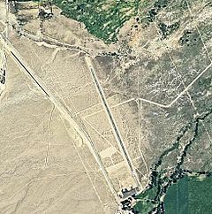
Airphoto of the airport
|
|||||||||||||||
| Summary | |||||||||||||||
| Airport type | Public | ||||||||||||||
| Location | Independence, California | ||||||||||||||
| Elevation AMSL | 3,900 ft / 1,189 m | ||||||||||||||
| Coordinates | 36°48′49.756″N 118°12′18.34″W / 36.81382111°N 118.2050944°W | ||||||||||||||
| Runway | |||||||||||||||
|
|||||||||||||||
Independence Airport is a small airport located in Independence, Inyo County, California. It is a public airport, meaning it is open for general use. This airport has two runways for planes to land and take off safely.
What is Independence Airport?
Independence Airport is a public airport. This means it is open for anyone to use, as long as they follow aviation rules. It is not a huge international airport. Instead, it serves the local community in Independence, California.
Airport Runways
The airport has two main runways. A runway is a long strip of land where planes take off and land.
- One runway is made of asphalt. It is about 3,722 feet (1,134 meters) long.
- The second runway is made of dirt. It is shorter, about 1,610 feet (491 meters) long.
These runways help different types of aircraft use the airport.
A Look at Airport History
Independence Airport has an interesting past. During World War II, it was used as a special place. It became a flight school site. Young pilots learned how to fly planes here. This helped prepare them for their important roles in the war.
 | Janet Taylor Pickett |
 | Synthia Saint James |
 | Howardena Pindell |
 | Faith Ringgold |

