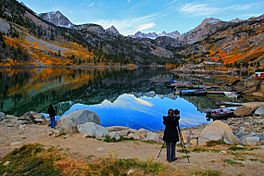
Lake Sabrina facts for kids
Quick facts for kids Lake Sabrina |
|
|---|---|
 |
|
| Location | Inyo County, California |
| Coordinates | 37°12′26″N 118°37′07″W / 37.2072689°N 118.618698°W |
| Type | reservoir |
| Primary outflows | Middle Fork Bishop Creek |
| Catchment area | 15.1 square miles (39 km2) |
| Basin countries | United States |
| Built | 1907 |
| Surface area | 184 acres (74 ha) |
| Water volume | 8,376 acre-feet (10.332×10⁶ m3) |
| Surface elevation | 9,128 feet (2,782 m) |
Lake Sabrina is a beautiful lake in the mountains of California. It's not a natural lake. It was created by building a dam across the middle part of Bishop Creek. This lake is found southwest of a town called Bishop. You can reach it by driving on California State Route 168. Lake Sabrina is part of the large Inyo National Forest.
Contents
What is Lake Sabrina?
Lake Sabrina is a type of lake called a reservoir. This means it was made by people. The dam was built a long time ago, between 1907 and 1908. Its main purpose was to make sure there was always enough water. This water was used for special power plants that create electricity using water power.
Location and Things to Do
The lake is located high up in the mountains. It's a popular spot for visitors. You can find a cafe there, which is a great place to grab a bite. There's also a dock, which is a good place for boats. The lake is part of a bigger water system known as the Bishop Creek system.
How to Say the Lake's Name
This lake has an interesting story about its name. Most people who live nearby say the name "Sah-bry-nuh." However, the lake was actually named after a woman named Mrs. Sabrina Hobbs. Her name was pronounced "suh-BREE-nuh." She was the wife of C.M. Hobbs. He was the first General Manager of the California Nevada Power Company. This company was the one that built the dam. It's not clear why the pronunciation of the lake's name changed over time.
Winter Road Closures
Getting to Lake Sabrina can be tricky in winter. A part of State Route 168, the road leading to the lake, often closes. This closure usually happens during the colder months. It affects the road from Lake Sabrina east towards a small community called Aspendell. The road closes because of heavy snow. It usually doesn't open again until mid- or late-April. The gate that closes the road for winter is actually located a bit southwest of Aspendell.
 | Jessica Watkins |
 | Robert Henry Lawrence Jr. |
 | Mae Jemison |
 | Sian Proctor |
 | Guion Bluford |


