Winchester, Nevada facts for kids
Quick facts for kids
Winchester, Nevada
|
|
|---|---|

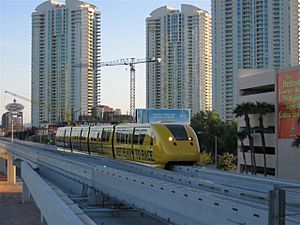
Sahara Hotel Station of the monorail
|
|

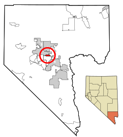
Location of Winchester in Clark County, Nevada
|
|
| Country | United States |
| State | Nevada |
| County | Clark |
| Founded | April 23, 1951 |
| Founded by | Clark County Commission |
| Area | |
| • Total | 4.96 sq mi (12.84 km2) |
| • Land | 4.96 sq mi (12.84 km2) |
| • Water | 0.00 sq mi (0.00 km2) |
| Elevation | 1,919 ft (585 m) |
| Population
(2020)
|
|
| • Total | 36,403 |
| • Density | 7,342.28/sq mi (2,834.66/km2) |
| Time zone | UTC−8 (PST) |
| • Summer (DST) | UTC−7 (PDT) |
| Area code(s) | 702 and 725 |
| FIPS code | 32-84600 |
| GNIS feature ID | 0845753 |
Winchester is a special area in Clark County, Nevada, United States. It is called an unincorporated town because it is not officially part of a city. It is also a census-designated place (CDP), which means it's an area defined just for counting people.
Winchester is located right next to Las Vegas and includes part of the famous Las Vegas Strip. In 2020, about 36,403 people lived there. The area is managed by the Clark County Commission, which acts like a local government, with help from the Winchester Town Advisory Board. Even though it's called Winchester, mail sent there uses "Las Vegas, NV" as the address.
History of Winchester
The area south of Las Vegas was known as Paradise Valley as early as 1910. People called it "Paradise" because it had a lot of underground water. This made the land very good for farming. A school district for Paradise was set up in 1914.
In 1950, the mayor of Las Vegas, Ernie Cragin, wanted to add the Las Vegas Strip to the city. The Strip was not officially part of any city. By adding it, Las Vegas could collect more taxes to pay for new buildings and reduce its debt.
However, some casino owners on the Strip did not want this to happen. They asked the county leaders to make the Strip a separate "town." This would stop Las Vegas from taking over the land without the county's permission.
On December 8, 1950, the county leaders voted to create the unincorporated town of Paradise. A month later, more residential areas were added to this new town. But then, officials found out that the town had not been set up correctly. There were not enough signatures on the petition, and it broke a state law about towns crossing different school districts.
So, on August 20, 1951, the county leaders approved petitions to create two new towns. These towns covered the same area as the first Paradise town.
- Town "A" of Paradise included areas within a Las Vegas school district.
- Town "B" included areas within the Paradise school district.
In 1953, Town A was renamed Winchester. Town B became known simply as Paradise. Later, in 1956, a state law combined all local school districts into one big county-wide school district. For the Las Vegas Valley, this became the Clark County School District.
Geography of Winchester
Winchester is located in the middle-eastern part of the Las Vegas Valley.
- To the north, it shares a border with Las Vegas.
- To the west and south, it borders the CDP of Paradise.
- To the east, it borders Sunrise Manor.
When looking at streets, Winchester is generally bordered by:
- Sahara Avenue to the north.
- Boulder Highway to the east.
- Desert Inn Road to the south.
- The Union Pacific Railroad tracks to the west.
There are also a few small parts of Winchester located west of Interstate 15.
Some of the famous casinos on the Las Vegas Strip that are located in Winchester include:
- The Sahara
- Fontainebleau Las Vegas
- Resorts World Las Vegas
- Circus Circus
- The Westgate
The United States Census Bureau says that Winchester covers a total area of about 4.3 square miles (11.1 square kilometers). All of this area is land.
Population and People
| Historical population | |||
|---|---|---|---|
| Census | Pop. | %± | |
| 1970 | 13,981 | — | |
| 1980 | 19,728 | 41.1% | |
| 1990 | 23,365 | 18.4% | |
| 2000 | 26,958 | 15.4% | |
| 2010 | 27,978 | 3.8% | |
| 2020 | 36,403 | 30.1% | |
| source: | |||
The table above shows how Winchester's population has grown over the years. In 2020, there were 36,403 people living there.
Here is a look at the different groups of people living in Winchester:
| Racial composition | 2020 | 2010 | 2000 |
|---|---|---|---|
| Hispanic or Latino | 47.9% | 44.6% | 29.0% |
| White (Non-Hispanic) | 26.2% | 37.2% | 54.9% |
| Black or African American | 12.8% | 7.8% | 6.7% |
| American Indian or Alaska Native | 0.4% | 0.5% | 0.7% |
| Asian | 7.7% | 6.8% | 5.3% |
| Native Hawaiian or Other Pacific Islander | 0.4% | 0.5% | 0.4% |
| Some other race | 0.8% | 0.1% | 0.1% |
| Two or more races | 3.9% | 2.3% | 2.9% |
In 2000, there were 26,958 people living in Winchester. These people lived in 11,986 households. About 20.2% of these households had children under 18 living with them. The average household had 2.24 people.
The median age in Winchester in 2000 was 40 years old. This means half the people were younger than 40 and half were older. For every 100 females, there were about 106 males.
The median income for a household was $32,251. The median income for a family was $39,451. About 14.0% of the population lived below the poverty line. This included 19.2% of those under 18 years old.
See also
 In Spanish: Winchester (Nevada) para niños
 | DeHart Hubbard |
 | Wilma Rudolph |
 | Jesse Owens |
 | Jackie Joyner-Kersee |
 | Major Taylor |

