Cal-Nev-Ari, Nevada facts for kids
Quick facts for kids
Cal-Nev-Ari, Nevada
|
|
|---|---|

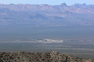
Seen from Spirit Mountain to the east; New York Mountains in the distance
|
|

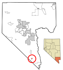
Location of Cal-Nev-Ari in Clark County, Nevada
|
|
| Country | United States |
| State | Nevada |
| County | Clark |
| Founded | 1965 |
| Named for | California, Nevada and Arizona |
| Area | |
| • Total | 2.28 sq mi (5.90 km2) |
| • Land | 2.28 sq mi (5.90 km2) |
| • Water | 0.00 sq mi (0.00 km2) |
| Elevation | 2,579 ft (786 m) |
| Population
(2020)
|
|
| • Total | 144 |
| • Density | 63.19/sq mi (24.39/km2) |
| Time zone | UTC-8 (PST) |
| • Summer (DST) | UTC-7 (PDT) |
| ZIP code |
89039
|
| Area code(s) | 702 and 725 |
| FIPS code | 32-08600 |
| GNIS feature ID | 0858257 |
Cal-Nev-Ari is a small community located in Clark County, Nevada, United States. It's found near the very southern tip of the state. The town's name is a clever mix of the names of three nearby states: California, Nevada, and Arizona.
As of the 2020 census, about 144 people call Cal-Nev-Ari home. It's known for being an airport-based community, meaning it was built around an airport.
History of Cal-Nev-Ari
Cal-Nev-Ari was started in 1965 by a couple named Nancy and Everette "Slim" Kidwell. They bought a large piece of land, about 640 acres, from the U.S. government. Their idea was to create a community centered around an airport.
Over the years, Cal-Nev-Ari grew. Besides the Kidwell Airport, which is officially recognized by the FAA, the community now has a casino, a motel, and places for RVs and mobile homes. There's also a convenience market and more than 100 spots for houses.
In 2010, the town was put up for sale for $17 million. It was later sold in 2016 for $8 million to a company called Heart of Nature. This company makes organic minerals and plans to use the local water to create sulfur products for farms.
Where is Cal-Nev-Ari?
Cal-Nev-Ari is located in the desert landscape of southern Nevada. It sits right on U.S. Route 95, a major highway. The community is about an hour's drive from the famous city of Las Vegas.
The total area of Cal-Nev-Ari is about 2.3 square miles (5.9 square kilometers). All of this area is land, with no water bodies like lakes or rivers within its boundaries.
Who Lives in Cal-Nev-Ari?
The population of Cal-Nev-Ari has changed over the years.
| Historical population | |||
|---|---|---|---|
| Census | Pop. | %± | |
| 2020 | 144 | — | |
| U.S. Decennial Census | |||
In the year 2000, there were 278 people living in Cal-Nev-Ari. These people lived in 154 households, with 93 of them being families. The community is quite spread out, with about 121 people per square mile.
Most of the households in 2000 were made up of married couples living together. About 7% of households had children under 18. Many people living in Cal-Nev-Ari were older, with about 34.5% being 65 years or older. The average age in the town was 59 years old.
See also
 In Spanish: Cal-Nev-Ari (Nevada) para niños
 | Sharif Bey |
 | Hale Woodruff |
 | Richmond Barthé |
 | Purvis Young |


