
Red Rock Canyon National Conservation Area facts for kids
Quick facts for kids Red Rock Canyon National Conservation Area |
|
|---|---|
|
IUCN Category V (Protected Landscape/Seascape)
|
|

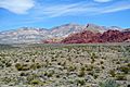
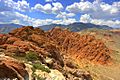
Red Rock Canyon National Conservation Area view.
|
|

Red Rock Canyon National Conservation Area
Location in Nevada
|
|
| Location | Clark County, Nevada, US |
| Nearest city | Las Vegas, Nevada |
| Area | 197,349 acres (798.64 km2) |
| Established | 1967 |
| Visitors | 2,000,000+ |
| Governing body | Bureau of Land Management |
The Red Rock Canyon National Conservation Area is a special place in Nevada, USA. It's managed by the Bureau of Land Management to protect its amazing natural beauty. Located about 15 miles west of Las Vegas, it's famous for its huge red rock formations. More than three million people visit this area every year!
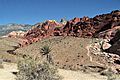
The conservation area has tall sandstone peaks and walls. These rocks were formed over millions of years by powerful movements in the Earth. Some walls are as high as 3,000 feet! This makes Red Rock Canyon a very popular spot for hiking and rock climbing. The highest point in the area is La Madre Mountain, which stands at 8,154 feet tall.
You can explore much of the area by driving on a 13-mile one-way loop road. This road gives you access to many cool spots. There are also side roads and parking areas where you can start different trails. A visitor center is located at the beginning of the loop road. The loop road is also great for bicycle touring, with a gentle climb at the start and then mostly flat or downhill sections.
A rough road called Rocky Gap Road leads to a side canyon. Only special off-road vehicles can usually get through this area. State Route 159 goes through Cottonwood Valley. From this road, you can see the huge Wilson Cliffs to the west. Near the southern end of the area, you'll find Spring Mountain Ranch State Park and the small town of Blue Diamond.
Contents
History of Red Rock Canyon
Ancient People and Red Rock


Long ago, the Red Rock area was a great place for early humans to live. It had water, plants, and animals that were hard to find in the dry desert nearby. Hunters and gatherers, like the Southern Paiute people and even older groups, lived here for thousands of years.
Many different Native American cultures have called Red Rock home. Here's a timeline of some of them:
- Southern Paiute: From about 900 AD to modern times.
- Patayan Culture: From 900 AD to the early 1800s.
- Ancestral Puebloan: From 1 AD to 1150 AD.
- Pinto/Gypsum: (Archaic) From 3500 BC to 1 AD.
- San Dieguito: From 7000 BC to 5500 BC.
- Paleo-Indians (Tule Springs): From 11,000 BC to 8000 BC.
You can still see many petroglyphs (ancient rock carvings) and pieces of pottery left by these early people. There are also old roasting pits where they cooked food.
Modern Times and Protection
In the early 1900s, when Las Vegas was just starting, a company tried to mine sandstone near the scenic loop. But it wasn't very profitable, so they stopped. You can still see some of the huge sandstone blocks they left behind.
Red Rock Canyon has also been a filming location for movies! For example, parts of the Roy Rogers movie Bells of San Angelo (1947) and The Stalking Moon (1968) were filmed here.
In 1967, the Bureau of Land Management set aside 10,000 acres of Red Rock as "Recreation Lands." Later, in 1990, a law was passed to make it a National Conservation Area. This special status helps protect the land and provides money to keep it safe and beautiful for everyone. A company called The Howard Hughes Corporation even gave some of their land next to Red Rock Canyon. This helps create a natural buffer zone between the protected area and nearby towns.
Plants and Animals

Red Rock Canyon is part of the Mojave Desert. The lower parts of the area are like a "Lower Sonoran Zone," while higher parts are an "Upper Sonoran Zone." Because of the way the sandstone layers are, you can find springs with water all year long in some of the side canyons.
About 600 different kinds of plants grow here! In the valley, you'll see plants like the Joshua tree, Mojave yucca, banana yucca, creosote bush, and blackbrush. Higher up, you'll find Utah juniper trees and scrub oak. Agave plants are easy to spot with their thick leaves and tall flower stalks. You can even find Ponderosa pine trees at the very top of the valley, connecting to the Spring Mountains.
You'll often see wild burros, rabbits, and ground squirrels. If you're lucky, you might spot desert bighorn sheep in the higher areas. After it rains, tiny red-spotted toads can appear from water pools.
The Red Rock Canyon area is a protected home for the desert tortoise. At the Visitor Center, there's a special habitat where you can see some of these tortoises.
Geology of Red Rock Canyon


The amazing landscape of Red Rock Canyon was formed over millions of years by a very complex geological history.
About 600 million years ago, during the Paleozoic Era, the Red Rock area was actually under an ocean! Thick layers of muddy sediments settled there and slowly turned into limestone.
Then, about 250 million years ago, in the Mesozoic Era, the Earth's surface started to lift up. More layers of shale and sandstone were laid down. As the area became cut off from the ocean, salt and gypsum formed. The red colors in some of the rocks come from iron minerals that rusted, just like metal rusts. You can even find petrified wood here, which formed from ancient trees buried in swamps.
Around 180 million years ago, the climate changed a lot, and the area became a huge desert. Giant sand dunes piled up, sometimes as thick as half a mile! Over time, these dunes hardened into the colorful Aztec Sandstone we see today.
Later, about 66 million years ago, during a time of mountain building, a huge crack in the Earth's crust formed. This is called the Keystone Thrust Fault. Along this fault, older gray rocks were pushed up and over the younger red rocks. This created the beautiful mix of colors you see in the mountains today. This fault line can be seen for about 13 miles across the Red Rock cliffs.
Fun Activities at Red Rock

Red Rock Canyon offers many fun things to do! The most popular activities are hiking, biking, and rock climbing. You can also go horseback riding and camping in certain areas. Car and motorcycle clubs often enjoy driving the 13-mile scenic loop. However, ATVs are not allowed.
It's important to be safe when visiting. Summer temperatures can get very hot, over 105°F, so always bring lots of water. If you hike off the main trails, it's best not to go alone. Tell someone your plans before you go. Watch out for rattlesnakes and be aware of sudden floods or lightning during thunderstorms.
Rock Climbing Adventures

Red Rock Canyon has huge walls that are great for climbing. People started climbing here in the late 1960s and early 1970s. The rock is called Aztec Sandstone, and it's very strong. Many climbs follow long cracks that go up hundreds of feet!
The climbs at Red Rock are for all skill levels. There are long, easier routes that are perfect for learning. But there are also many very difficult climbs for experienced climbers. Because of its variety and amazing routes, Red Rock Canyon is a famous place for rock climbers from all over the world.
Some popular climbing spots include the Calico Hills and Sandstone Quarry. There are also many places for traditional climbing, like Brass Wall and Solar Slab. If you like bouldering (climbing on large rocks without ropes), check out the Kraft Boulders and Black Velvet Canyon.
Hiking Trails


Red Rock has many hiking trails and picnic areas. The trails are sometimes changed to help protect the plants and animals. In early spring, if there's been enough rain, you might even see waterfalls flowing down the canyons! Some popular trails near the scenic drive loop include the Moenkopi Loop, Calico Hills, Calico Tanks, Turtlehead Peak, and Ice Box Canyon.

Wildfires in Red Rock Canyon

Several large wildfires have happened in Red Rock Canyon in recent years:
- 1998: A fire burned in the loop area.
- June 25, 2005: The Goodsprings fire burned over 31,600 acres, reaching the southern part of Red Rock.
- July 22, 2005: Lightning caused an 800-acre fire in the loop area.
- September 6, 2006: Another lightning-caused fire burned about 1,500 acres near the visitor center.
- July 2013: The Carpenter I fire mainly burned in the Spring Mountains National Recreation Area, but it also touched the northwest part of Red Rock Canyon.
You can see the effects of these fires from the loop road. You can also see how the desert slowly recovers over time. Some recent fires were made worse by thick growths of invasive species like red brome and cheat grass. These plants are not native to the area and can spread fires quickly.
Images for kids
-
Red Rock Canyon National Conservation Area view.
-
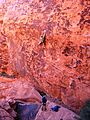
Pictographs in Red Rock Canyon.
-
Lomatium parryi, a common plant consumed by early Native Americans.
-
Red Rock Canyon – Calico Hills trail.
-
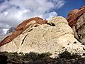
An outcrop of Aztec Sandstone.
-
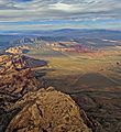
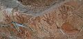
Aerial view of the Red Rock Canyon National Conservation Area near Las Vegas, Nevada, looking northeast.
-
Climbers at the second pullout of the scenic loop.
-
White Rock Mountain Loop Trail, one of the many trails that can be seen by visitors to Red Rock.
-
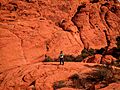
A hiker on the Grand Circle Loop Trail in Red Rock Canyon National Conservation Area.
-
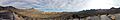
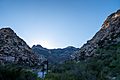
View from High Point Overlook.
-
Calico Basin in Red Rock Canyon.
See also
 In Spanish: Área de conservación nacional Red Rock Canyon para niños
