Whitney, Nevada facts for kids
Quick facts for kids
Whitney, Nevada
|
|
|---|---|

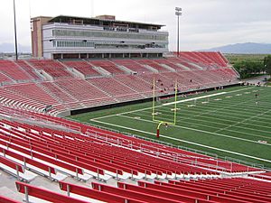
Sam Boyd Stadium in 2005
|
|

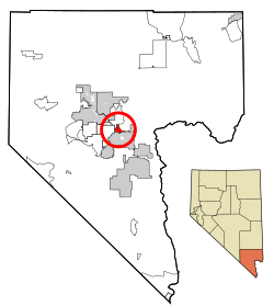
Location of Whitney in Clark County, Nevada
|
|
| Country | United States |
| State | Nevada |
| County | Clark |
| Founded | 1931 |
| Named for | Stowell E. Whitney |
| Area | |
| • Total | 6.81 sq mi (17.64 km2) |
| • Land | 6.81 sq mi (17.64 km2) |
| • Water | 0.00 sq mi (0.00 km2) |
| Elevation | 1,942 ft (592 m) |
| Population
(2020)
|
|
| • Total | 49,061 |
| • Density | 7,204.26/sq mi (2,781.45/km2) |
| Time zone | UTC−8 (PST) |
| • Summer (DST) | UTC−7 (PDT) |
| Area code(s) | 702 and 725 |
| FIPS code | 32-83800 |
| GNIS feature ID | 1877236 |
| Website | Whitney Town Advisory Board |
Whitney is a town in Clark County, Nevada, in the United States. It used to be called East Las Vegas. Whitney is an unincorporated town, which means it is not officially a city with its own local government. It is also a census-designated place, which is an area the government uses for counting people. In 2020, about 49,061 people lived there.
Contents
History of Whitney
How Whitney Started
Whitney was named after Stowell E. Whitney, a dairy farmer. He bought a large ranch in the area in the 1910s. In 1931, he divided his ranch into smaller pieces of land to sell. This happened because a new road, the Boulder Highway, was being built nearby.
However, it was during the Great Depression, so not many people bought land. A post office opened in Whitney the next year. In 1942, the Clark County Commission officially recognized Whitney as a town and gave it official borders.
Name Changes
In 1958, almost everyone living in Whitney signed a petition to change the town's name. They wanted it to be called East Las Vegas. So, the name was changed. But in 1993, the name was changed back to Whitney.
Life in Early Whitney
Before the 1970s, Whitney was one of a few small towns between Las Vegas and Henderson. These towns were located along the Boulder Highway. The Whitney Elementary School was once a converted army building. It taught students from first to seventh grade until the 1960s. After that, seventh graders went to Henderson Junior High.
John and Nellie Bunch owned a lot of land in Whitney. They also ran the town's post office in the early years. The town had three main streets that ran east and west: Whitney Avenue, Keenan Avenue, and Missouri Avenue. The streets that ran north and south were 1st Street, 2nd Street, and 3rd Street. Older students from Whitney went to Basic High School in Henderson or Chaparral High School in East Las Vegas.
Modern Whitney
In the early 1990s, the cities of Las Vegas and Henderson grew outwards. Also, a new highway, Interstate 515 (now Interstate 11), was built around Whitney. This meant less traffic went through Whitney, which hurt local businesses.
However, businesses started to get better in the 2000s. Many new homes have been built on empty land in the area. People who live here often call the neighborhood "East Las Vegas" or "Boulder District" (BD).
Whitney is also home to Sam Boyd Stadium. This stadium used to be where the UNLV Rebels college football team played their games.
Geography
Whitney covers an area of about 17.5 square kilometers (6.8 square miles). All of this area is land. The boundaries used for counting the population (called a census-designated place) might be a bit different from the town's actual borders.
Population Information
The number of people living in Whitney has grown a lot over the years.
- 1970: 6,501 people
- 1980: 6,449 people
- 1990: 11,087 people
- 2000: 18,273 people
- 2010: 38,585 people
- 2020: 49,061 people
In 2000, there were 18,273 people living in Whitney. About 28.7% of the homes had children under 18. The average age of people in Whitney was 35 years old.
See also
 In Spanish: Whitney (Nevada) para niños
 | Aaron Henry |
 | T. R. M. Howard |
 | Jesse Jackson |

