Bonnie Claire, Nevada facts for kids
Quick facts for kids
Bonnie Claire
|
|
|---|---|

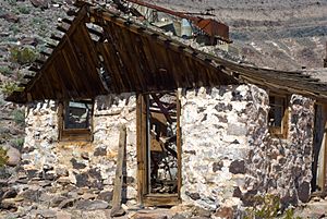
Abandoned bunkhouse at the Bonnie Claire Mine; ruins of the mine shaft head in the background.
|
|
| Country | United States |
| County | Nye |
| State | Nevada |
| Elevation | 3,980 ft (1,213 m) |
| Time zone | UTC-8 (Pacific (PST)) |
| • Summer (DST) | PDT (UTC-7) |
| GNIS feature ID | 863886 |
Bonnie Claire is a ghost town located in Nye County, Nevada. A ghost town is a place that used to be a busy town but is now mostly empty. It sits on the edge of a flat area called Sarcobatus Flat. You can find it right next to Nevada State Route 267. To the northwest are the mines of Slate Ridge. The northern part of the Amargosa Range, called the Grapevine Mountains, is just south of the town.
Contents
A Look Back in Time
Bonnie Claire started as a town in 1906. It was built to support the gold mines in the Slate Ridge area. Before it was called Bonnie Claire, it was known as Thorp's Wells. This older camp began in the 1880s. Its main job was to process gold ore from Gold Mountain.
How the Town Grew
When two railroads arrived in 1906, business really boomed. These were the Bullfrog-Goldfield Railroad and the Las Vegas and Tonopah Railroad. With the railroads, more people and supplies could come to the town. This is when the site was renamed Bonnie Claire.
The Town's Decline
After 1914, the gold mines started to run out of gold. Because of this, the town began to get smaller. Fewer people lived and worked there.
A New Purpose in the 1920s
Even though the mines were slowing down, Bonnie Claire found a new purpose. In the 1920s, it became a supply point for building Scotty's Castle. This famous castle is located in Death Valley, about 20 miles southwest of Bonnie Claire.
Post Office History
The town's post office had two names. It was called Thorp from June 1905 until July 1909. Then, it was renamed Bonnie Claire in July 1909. The post office finally closed its doors in December 1931.
 | Mary Eliza Mahoney |
 | Susie King Taylor |
 | Ida Gray |
 | Eliza Ann Grier |


