Bunker Hill (Nevada) facts for kids
Quick facts for kids Bunker Hill |
|
|---|---|

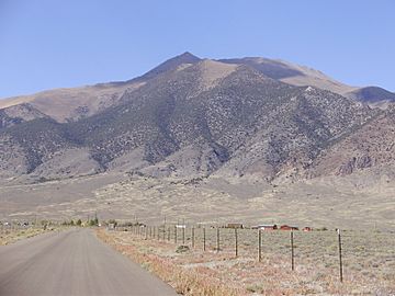
View of Bunker Hill from Kingston
|
|
| Highest point | |
| Elevation | 11,477 ft (3,498 m) NAVD 88 |
| Prominence | 2,793 ft (851 m) |
| Listing | Nevada County High Points 5th |
| Geography | |
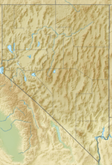
| Location | Lander County, Nevada, U.S. |
| Parent range | Toiyabe Range |
| Topo map | USGS BUNKER HILL |
| Climbing | |
| Easiest route | From Kingston Summit, southeast along a 4-wheel drive road and then the ridgeline, Class 2 scramble |
Bunker Hill is a tall mountain located in the middle of Nevada, in the United States. It is the highest point in Lander County and is part of the Toiyabe Range. This mountain is also the twenty-second highest mountain in the entire state of Nevada. It sits within a large protected area called the Humboldt-Toiyabe National Forest.
Where is Bunker Hill?
Bunker Hill is found in Lander County, Nevada. It is part of the long Toiyabe Range of mountains. The mountain is about 17 miles south of a small town called Austin. It is also just northwest of another small town named Kingston.
How Tall is Bunker Hill?
Bunker Hill stands at an impressive height of 11,477 feet (about 3,498 meters) above sea level. This makes it the tallest mountain in Lander County. It is also one of the highest mountains in Nevada, ranking as the twenty-second tallest in the state.
Climbing Bunker Hill
The easiest way to climb Bunker Hill starts from Kingston Summit. From there, you can follow a road that is made for 4-wheel drive vehicles. After that, the path continues along the top of a ridge. This part of the climb is called a "Class 2 scramble." A Class 2 scramble means you might need to use your hands sometimes to keep your balance, but it's not very difficult climbing.
Summit Panorama
From the very top of Bunker Hill, you can see amazing views all around. It offers a full 360-degree panorama of the surrounding mountains and valleys.
 | Isaac Myers |
 | D. Hamilton Jackson |
 | A. Philip Randolph |


