Kingston, Nevada facts for kids
Quick facts for kids
Kingston, Nevada
|
|
|---|---|

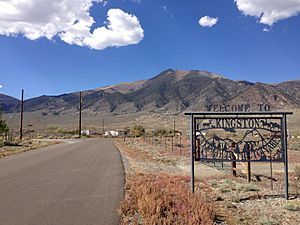
Entrance to Kingston from Nevada State Route 376. Bunker Hill is visible in the background.
|
|
| Country | United States |
| State | Nevada |
| Area | |
| • Total | 4.07 sq mi (10.54 km2) |
| • Land | 4.07 sq mi (10.54 km2) |
| • Water | 0.00 sq mi (0.00 km2) |
| Elevation | 5,955 ft (1,815 m) |
| Population
(2020)
|
|
| • Total | 194 |
| • Density | 47.69/sq mi (18.41/km2) |
| Time zone | UTC-8 (Pacific (PST)) |
| • Summer (DST) | UTC-7 (PDT) |
| ZIP code |
89310
|
| Area code(s) | 775 |
| FIPS code | 32-38100 |
| GNIS feature ID | 2583936 |
Kingston is a small community in Lander County, Nevada, United States. It is known as an unincorporated town, which means it doesn't have its own local government like a city does. Instead, it's managed by the county. Kingston is also a census-designated place, which is an area the U.S. Census Bureau defines for gathering population data. In 2020, about 194 people lived there.
Where is Kingston Located?
Kingston is found in the southern part of Lander County. It sits on the northeast side of the Toiyabe Range, which is a mountain range. A very tall mountain called Bunker Hill is nearby. It's the highest point in Lander County.
The main road that goes through Kingston is Nevada State Route 376. This road can take you north about 20 miles (32 km) to Austin. If you head south, it's about 90 miles (145 km) to Tonopah. The total area of Kingston is about 4.07 square miles (10.5 square kilometers), and it's all land.
Who Lives in Kingston?
| Historical population | |||
|---|---|---|---|
| Census | Pop. | %± | |
| 2020 | 194 | — | |
| U.S. Decennial Census | |||
The number of people living in Kingston has changed over time. In 2010, there were 113 residents. By 2020, the population grew to 194 people. This information comes from the official U.S. Census, which counts everyone in the country every ten years.
See also

- In Spanish: Kingston (Nevada) para niños
 | Tommie Smith |
 | Simone Manuel |
 | Shani Davis |
 | Simone Biles |
 | Alice Coachman |


