
Black Rock Desert facts for kids
Quick facts for kids Black Rock Desert |
|
|---|---|
 |
|
| Length | 100 mi (160 km) |
| Area | 1,000 sq mi (2,600 km2) |
| Geography | |
| Location | |
| Country | United States |
| State | Nevada |
| County | Humboldt, Pershing and Washoe |
| Population center | Gerlach, Nevada |
| River | Quinn River |
The Black Rock Desert is a large, dry area in Nevada, United States. It is famous for its huge, flat lakebed, which is a leftover from an ancient lake. This desert is part of the Great Basin, a unique region where water stays within the land and doesn't flow to the ocean.
The Black Rock Desert is known for its amazing natural features. It was also an important route for pioneers heading to California in the 1800s. Today, it is a popular place for setting land speed records and launching rockets. It also hosts the yearly Burning Man event.
This desert is a protected area called the Black Rock Desert–High Rock Canyon Emigrant Trails National Conservation Area. It covers over 300,000 acres (120,000 ha) of land.
Contents
Exploring the Black Rock Desert's Geography
The Black Rock Desert is located in northwestern Nevada. It is part of the larger Great Basin region. The flat, dry lakebed, called a playa, stretches for about 100 miles (160 km). It lies between the Jackson Mountains to the east and the Calico Hills to the west.
The desert is split into two parts by the Black Rock Range. Its elevation is about 3,907 feet (1,191 m) above sea level. The total area of the desert is around 1,000 square miles (2,600 km²).
Understanding the Desert's Water System
The Black Rock Desert is a "sink" area. This means water flows into it but does not flow out to the ocean. The water either sinks into the ground or evaporates. The Quinn River is the biggest river in this area. It starts in the Santa Rosa Range and ends in the Quinn River Sink on the playa.
When the playa gets wet from rain, it becomes a temporary home for tiny creatures called fairy shrimp. These shrimp hatch from eggs that can stay dormant in the dry ground for many years. The wet areas also attract over 250 types of migratory birds. These birds stop here to rest and find food.
The playa can become very sticky when wet. This makes it hard for vehicles to drive on it. Some parts of the Black Rock Desert are very sensitive to the environment. Vehicles are not allowed in these areas.
Mountains of the Black Rock Region
Many mountain ranges are found within or near the Black Rock Desert. They add to the rugged beauty of the landscape.
- Antelope Range
- Badger Mountains
- Black Rock Range
- Calico Hills
- Division Range
- Fox Range
- Granite Range
- Hannan Range
- High Rock Canyon Hills
- Hog Ranch Mountains
- Jackson Mountains
- Kamma Mountains
- Little High Rock Mountains
- Massacre Range
- Montana Mountains
- Pine Forest Range
- Poker Brown Mountains
- Selenite Range
- Sentinel Hills
- Seven Troughs Range
- Sheephead Mountains
- Smoke Creek Mountains
- Yellow Hills
Unique Geologic Features
The desert has many interesting volcanic and geothermal features. There are two "Black Rock Points" at the southern end of the Black Rock Range. These points have dark volcanic rocks.
The flat lakebed is a remnant of Lake Lahontan, a huge ancient lake. This area also has many hot springs. One famous hot spring is the Fly Geyser. It started in 1916 when a well drilling accidentally hit a geothermal source.
History of the Black Rock Desert
Humans have lived in the Black Rock Desert area for about 10,000 years. Around 1300 CE, the Paiute people settled here. They used a large, black rock formation as a landmark. This landmark was also important for pioneers crossing the desert. It had a hot spring and grassy meadow at its base.
In 1843, John Frémont and his group were the first white explorers to cross the desert. After 1849, many gold seekers used his trail to reach California. In 1867, a silver mining town called Hardin City was built. It is now a ghost town.
Early Exploration and Trails
About 15,000 years ago, the Humboldt River flowed into this area. When Lake Lahontan dried up, the river changed its path. During the highest water level of Lake Lahontan, the lakebed was under about 500 feet (150 m) of water. This created the flat surface we see today.
In the late 1840s, Peter Lassen led pioneers through the desert using the Applegate-Lassen Cutoff. This was a very difficult route. By 1910, the Western Pacific Railroad built a railway across the east side of the lakebed.
Mining in the Desert
People have been looking for and digging up minerals in the Black Rock region since the mid-1800s. For example, USG Corporation used to operate a gypsum mine and a drywall factory in Empire.
The Hycroft Gold Mine was reopened in 2008. It is an open-pit mining operation located in the Kamma Mountains. There is also an opal mine at the base of the Calico Hills.
Ancient Discoveries
Bones of mammoths that lived here around 20,000 BCE have been found. In 1979, a fossilized Columbian mammoth was discovered. Copies of its bones are now on display at the Nevada State Museum, Carson City.
Black Rock Desert: A Place for Records
The super flat surface of the Black Rock Desert's lakebed makes it perfect for testing experimental vehicles. It has been the site of several world records.
Land Speed Records
The Black Rock Desert is famous for setting land speed records.
- In 1983, Richard Noble drove the jet-powered Thrust2 car. He set a new record of 634.015 mph (1,020.346 km/h).
- In 1997, the ThrustSSC car, driven by Andy Green, became the first car to break the sound barrier. It reached an amazing speed of 763.035 mph (1,227.985 km/h).
Rocketry Records and Attempts
The desert's flat surface and open airspace also attract rocket experimenters. Many amateur rocket records have been set here.
- On November 23, 1996, the Reaction Research Society launched a rocket to 50 miles (80 km) high. This was a big jump in amateur rocket altitude records.
- On May 17, 2004, the Civilian Space eXploration Team (CSXT) launched a rocket to 72 miles (116 km) high. This was the first amateur rocket to cross the Kármán line. The Kármán line is 62.14 miles (100 km) high and is considered the boundary of space.
Other groups have also tried to launch rockets into space from the Black Rock Desert. The University of Southern California's Rocket Propulsion Laboratory (USCRPL) has made attempts with their Traveler rockets.
Getting Around the Black Rock Desert
Nevada State Route 447 is the main highway in the area. It connects Gerlach to Wadsworth, Nevada. The dirt roads in the desert can be hard to use when it's wet or snowy.
The Union Pacific Railroad also runs along the east side of the lakebed. It was built in the early 1900s. Light aircraft can even land on the lakebed for special events.
Images for kids
-
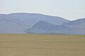
Black Rock Point with mirage
-
Black Rock Desert, Nevada, February 26, 2017, Sentinel-2 true-color satellite image, scale 1:190,000.
-
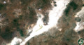
Black Rock Desert, Nevada, July 16, 2017, Sentinel-2 true-color satellite image, scale 1:190,000.
-
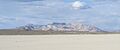
Calico Hills, Humboldt County, Nevada
-
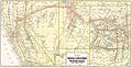
1914 WPRR map with Gerlach, Ascalon, Trego, Cholona, Ronda, and Sulphur, Nevada
-
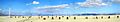
Lakebed during 2006 rocket launch


See also
 In Spanish: Desierto de Black Rock para niños
