
Great Basin montane forests facts for kids
Quick facts for kids Great Basin montane forests |
|
|---|---|

|
|

Location in North America
|
|
| Ecology | |
| Realm | Nearctic |
| Biome | Temperate coniferous forests |
| Borders | Great Basin shrub steppe and Mojave Desert |
| Bird species | 160 |
| Mammal species | 91 |
| Geography | |
| Country | United States |
| States | California and Nevada |
| Conservation | |
| Habitat loss | 25-50% |
| Protected | 97.53% |
The Great Basin montane forests are a special type of forest found in the Great Basin region of the United States. These forests are part of a larger group called Temperate coniferous forests. They are recognized by the World Wildlife Fund (WWF) as a unique ecoregion.
Contents
Geography of the Great Basin Forests
These forests are mostly found in Nevada, eastern California, and western Utah. They are located in the western part of the United States.
You'll often find these mountain forests on what are called "sky islands." Imagine tall mountains rising like islands out of a drier, lower desert area. These forests grow high up on these mountains, above the Great Basin Desert or other dry shrublands. They are part of the Environmental Protection Agency's defined regions for the Central or Northern Basin and Range ecoregions.
Amazing Trees and Animals
The Great Basin montane forests are home to many interesting trees. At middle elevations, you might see white fir, Douglas fir, and ponderosa pine trees. Higher up, closer to the very top of the mountains, you'll find limber pine, subalpine fir, Engelmann spruce, and the famous bristlecone pine.

On slopes that are drier and warmer, especially those facing south, you'll often see Mountain mahogany trees. You can also find pure groups of aspen trees in these forests.
The Incredible Bristlecone Pine
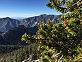
The bristlecone pine is a very important tree in these forests. It's known for living an incredibly long time, sometimes for thousands of years! These trees grow in very tough places where other plants can't survive. This means they don't have much competition for resources. Also, there's less risk of fires in these harsh, rocky areas.
Bristlecone pines grow very slowly. This slow growth makes their wood super dense and strong, which helps them resist diseases. All these things help the bristlecone pine live for a very long time. You can find these ancient trees in protected areas like the Snake Range peaks in Great Basin National Park in Nevada. Another famous spot is the Ancient Bristlecone Pine Forest in the White Mountains of California.
Different Mountain Areas (Subregions)
Scientists divide the Great Basin montane forests into smaller areas. These areas are different based on their elevation and where they are located. Since many of these forests are on "sky islands," they are often separated from each other. Generally, the farther a mountain range is from the Rocky Mountains, the fewer types of plants and animals it might have.
Woodland and Shrub-Covered Low Mountains
This area includes lower, rocky mountain ranges and foothills. There's enough moisture here for open groups of juniper and pinyon pine trees. Above the pinyon trees, you'll find a zone of mountain brush. In southeastern Nevada, this area is a mix of the Colorado Plateau, Great Basin Desert, and Mojave Desert. Here, you might see Gambel oak, scrub oak, Joshua tree, and blue grama grass growing with the pinyon–juniper woodlands. Summer rain helps these woodlands grow well.
High-Elevation Carbonate Mountains
These mountains are made of rocks like limestone and dolomite. Even though much of the rain soaks through the porous rock, these mountains support many types of conifer trees. These include white fir, Douglas-fir, and Engelmann spruce. They also have more different kinds of plants growing beneath the trees than other mountains in Nevada at similar heights. Bristlecone pines are very common here, especially above 9,500 feet (2,900 meters).
Lahontan Uplands
The Lahontan Uplands are the highest parts of the mountain ranges within the Lahontan Salt Shrub Basin. These slopes are covered with sagebrush, grasses, and scattered Utah juniper trees. Pinyon pines grow with juniper in some parts, but are mostly absent from this area. Low sagebrush and black sagebrush grow all the way to the mountaintops. In the north, cool season grasses like bluebunch wheatgrass are common. In the south, warm season grasses like Indian ricegrass take over.
High-Elevation Ruby Mountains

The Ruby Mountains in Nevada are made of granitic and metamorphic rock. They were heavily covered by glaciers a long time ago. Even today, you can see effects of freezing and thawing at higher elevations. These mountains get more rain than other high-elevation mountains nearby. They have some of the largest groups of aspen trees in Nevada. You'll also find Subalpine meadows and scattered white fir, limber pine, and whitebark pine trees. These grow up to the jagged, exposed peaks, which are over 11,000 feet (3,350 meters) high. Snowmelt creates many alpine meadows and lakes. Animals like mule deer, bighorn sheep, and mountain goats live here.
Carbonate Woodland
In the Carbonate Woodland Zone, pinyon-juniper woodlands grow over and among sagebrush and mountain brush areas. These woodlands can grow at a wider range of elevations here, even on the floors of higher basins. This is partly because of more summer rain. In the past, miners cut these trees for timber. More recently, large areas have been cleared to create more grazing land for cattle. The plants growing under the trees are very diverse due to the type of rock and summer rainfall. This area also has more springs and streams than other woodlands because the carbonate rock allows water to soak in quickly.
Tonopah Uplands
The Tonopah Uplands include hills and mountains that are covered with woodlands or shrubs. Their elevations range from 6,000 to 9,500 feet (1,800 to 2,900 meters). In this region, plants from both the Great Basin Desert and Mojave Desert mix together. This is especially true towards the south and east. Here, you might find Gambel oak and other chaparral plants. Pinyon-juniper woodlands are common between 6,000 and 8,000 feet (1,800 and 2,400 meters). The very highest peaks might have a few white fir, limber pine, or bristlecone pine trees.
Images for kids
-
Bristlecone pine foliage and pollen cones, Spring Mountains, Nevada

