Beowawe, Nevada facts for kids
Quick facts for kids
Beowawe, Nevada
|
|
|---|---|

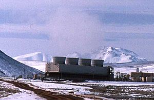
Beowawe geothermal power plant, 1996
|
|
| Country | United States |
| State | Nevada |
| County | Eureka |
| Time zone | UTC-8 (Pacific (PST)) |
| • Summer (DST) | UTC-7 (PDT) |
| GNIS feature ID | 856191 |
Beowawe (pronounced bay-oh-WAH-wee) is a small town in Eureka County, Nevada, United States. It is an unincorporated community, meaning it does not have its own local government like a city or town.
About Beowawe
This community is home to a mining operation and a geothermal power plant. A geothermal power plant uses heat from deep inside the Earth to make electricity. Beowawe also has a public library.
The name Beowawe comes from a Paiute Native American word. It means "gate." This name was chosen because of the unique shape of the hills near the town. They look like a gateway opening up to the valley beyond.
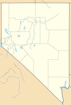
Beowawe is located about 4,695 feet (1,431 meters) above sea level. It is situated on State Route 306, about 5 miles (8 km) south of Interstate 80. The Humboldt River flows near Beowawe in northern Nevada. This river is about 300 miles (480 km) long. It is the second longest river in the dry Great Basin area of North America. The Humboldt River does not flow into an ocean. Instead, it ends in a dry lakebed called the Humboldt Sink.
Beowawe's Past
Beowawe was founded in 1868. This happened when the first transcontinental railroad arrived in the area. A famous spot on the California Trail called Gravelly Ford is about six miles east of Beowawe. The California Trail was a path used by pioneers traveling west.
A well-known marker called "Maiden's Grave" overlooks Gravelly Ford. A tall cross in the Beowawe cemetery honors Lucinda Duncan. She was a grandmother who died on the trail in 1863 and was buried there. Railroad workers first noticed her grave along the Humboldt River. In 1906, it was moved to the hillside cemetery when the Union Pacific railroad changed its tracks.
The town grew the most around 1881. At that time, about 60 people lived there. Beowawe had an elementary school, a church, a post office, a store, and a library. A power plant was built in 1909. However, like many boomtowns, Beowawe's growth ended by 1916. Many residents moved away, and it became almost a ghost town. Today, Beowawe is again important for energy. It has a geothermal power plant and a large propane storage area near the railroad.
Earth's Heat at Beowawe
Beowawe is known for its geothermal system. This means there is heat coming from deep within the Earth. On the surface, you can see a special terrace made of rock. It is about 215 feet (65 meters) high and 1 mile (1.6 km) long. This terrace was formed by hot springs and steam vents.
Since 1959, different companies have explored this area. They wanted to see if they could use the steam to make electricity. There is a large plume of hot water and steam that comes out near the top of the rock terrace. This is not a natural geyser. Instead, it comes from a geothermal well that was drilled and left uncapped.
Before the power plant started working, there were photos showing smaller hot springs and steam vents. It is not known if these smaller features are still active today. The large plume from the uncapped well stopped being active around 1985 or 1986. This happened when the local geothermal power plant began its operations.
The man-made geyser at Beowawe is similar to Fly Geyser in northwestern Nevada. Both were created by drilling for geothermal energy. However, Beowawe was developed to produce clean energy, while Fly Geyser was not. Fly Geyser also has more travertine rock formations, which makes it look different. This suggests the water chemistry is different in the two geothermal systems.
Beowawe's Weather
Beowawe has a cool semi-arid climate. This means it is generally dry, but it can get cold, especially in winter.
| Climate data for Beowawe | |||||||||||||
|---|---|---|---|---|---|---|---|---|---|---|---|---|---|
| Month | Jan | Feb | Mar | Apr | May | Jun | Jul | Aug | Sep | Oct | Nov | Dec | Year |
| Record high °F (°C) | 69 (21) |
72 (22) |
79 (26) |
90 (32) |
98 (37) |
105 (41) |
108 (42) |
108 (42) |
101 (38) |
92 (33) |
85 (29) |
78 (26) |
108 (42) |
| Mean daily maximum °F (°C) | 40.3 (4.6) |
45.7 (7.6) |
54.4 (12.4) |
63.1 (17.3) |
72.8 (22.7) |
82.4 (28.0) |
92.4 (33.6) |
90.5 (32.5) |
81.1 (27.3) |
68 (20) |
52.3 (11.3) |
41.3 (5.2) |
65.4 (18.6) |
| Mean daily minimum °F (°C) | 14 (−10) |
20.1 (−6.6) |
25.6 (−3.6) |
30.3 (−0.9) |
37.3 (2.9) |
44.2 (6.8) |
50.5 (10.3) |
47.4 (8.6) |
38.3 (3.5) |
29.2 (−1.6) |
21.5 (−5.8) |
14.9 (−9.5) |
31.1 (−0.5) |
| Record low °F (°C) | −35 (−37) |
−36 (−38) |
−7 (−22) |
7 (−14) |
10 (−12) |
19 (−7) |
26 (−3) |
24 (−4) |
12 (−11) |
1 (−17) |
−14 (−26) |
−43 (−42) |
−43 (−42) |
| Average precipitation inches (mm) | 0.78 (20) |
0.62 (16) |
0.64 (16) |
0.77 (20) |
1.02 (26) |
0.71 (18) |
0.29 (7.4) |
0.33 (8.4) |
0.38 (9.7) |
0.55 (14) |
0.7 (18) |
0.75 (19) |
7.53 (191) |
| Average snowfall inches (cm) | 5.3 (13) |
3.2 (8.1) |
2.2 (5.6) |
1.2 (3.0) |
0 (0) |
0 (0) |
0 (0) |
0 (0) |
0 (0) |
0.2 (0.51) |
1.4 (3.6) |
3.9 (9.9) |
17.5 (44) |
| Average precipitation days | 5 | 5 | 5 | 4 | 5 | 3 | 2 | 2 | 2 | 3 | 4 | 4 | 44 |
| Source: WRCC | |||||||||||||
See also
 In Spanish: Beowawe (Nevada) para niños
 | John T. Biggers |
 | Thomas Blackshear |
 | Mark Bradford |
 | Beverly Buchanan |


