Mount Lewis (Nevada) facts for kids
Quick facts for kids Mount Lewis |
|
|---|---|

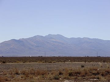
A view of Mount Lewis from Interstate 80 near Battle Mountain
|
|
| Highest point | |
| Elevation | 9,678 ft (2,950 m) NAVD 88 |
| Prominence | 4,280 ft (1,305 m) |
| Geography | |
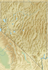
| Location | Lander County, Nevada, U.S. |
| Parent range | Shoshone Range |
| Topo map | USGS MT LEWIS |
| Climbing | |
| Easiest route | A well-maintained gravel road ascends directly to the summit |
Mount Lewis is a tall mountain located in Lander County, Nevada, in the United States. It is the highest point in the Shoshone Range of mountains. Standing at 9,678 feet (about 2,950 meters) tall, it's a really important peak in the area!
Mount Lewis is also known for being the most prominent peak in Lander County. This means it sticks out a lot from the land around it, making it easy to spot. It's even the twentieth most prominent peak in all of Nevada! The mountain is about 14 miles southeast of a town called Battle Mountain.
What's on Top of Mount Lewis?
Near the top of Mount Lewis, there's a special station run by the FAA. This station has a big radar that helps track airplanes flying far away. It's like a giant eye in the sky, making sure planes stay safe on their routes!
Can You Visit Mount Lewis?
Yes, you can! Mount Lewis is on public land, which means it's open for everyone to visit. This land is managed by the Bureau of Land Management, a government group that takes care of public lands. There are no special rules stopping you from exploring this mountain. In fact, there's a good gravel road that goes right up to the very top, making it easy to reach the summit.
Amazing Views from the Summit
When you reach the top of Mount Lewis, you can see amazing views all around! It's a great spot to look out over the vast landscapes of Nevada.
 | Kyle Baker |
 | Joseph Yoakum |
 | Laura Wheeler Waring |
 | Henry Ossawa Tanner |


