
Battle Mountain, Nevada facts for kids
Quick facts for kids
Battle Mountain, Nevada
|
|
|---|---|

Front Street in downtown Battle Mountain
|
|

Location of Battle Mountain, Nevada
|
|
| Country | United States |
| State | Nevada |
| County | Lander |
| Area | |
| • Total | 6.12 sq mi (15.84 km2) |
| • Land | 6.11 sq mi (15.83 km2) |
| • Water | 0.01 sq mi (0.01 km2) |
| Elevation | 4,521 ft (1,378 m) |
| Population
(2020)
|
|
| • Total | 3,705 |
| • Density | 606.09/sq mi (234.02/km2) |
| Time zone | UTC−8 (Pacific (PST)) |
| • Summer (DST) | UTC−7 (PDT) |
| ZIP code |
89820
|
| Area code(s) | 775 |
| FIPS code | 32-04900 |
| GNIS feature ID | 2407804 |
| Reference #: | 95 |
Battle Mountain is a town in Nevada, United States. It is the main town of Lander County. In 2020, about 3,705 people lived there. The town's main jobs are in gold mining. Some people also work in gambling.
Battle Mountain sits along Interstate 80, a major highway. It is located between the cities of Winnemucca and Elko.
Contents
A Look Back: Battle Mountain's History
The area around Battle Mountain was first home to the Northern Paiute and Shoshone peoples. Fur trappers explored this region in the 1820s and 1830s. By 1845, it became a stopping point for people traveling west on the Emigrant Trail. This trail followed the Humboldt River. Local stories say the town got its name from fights between Native Americans and early settlers in the 1850s.
Mining and Railroads Arrive
In 1866, people found copper ore in the area. Mining began, and the Central Pacific Railroad built a station nearby to help. In 1868, the railroad added a special track in Battle Mountain. By 1870, the main station moved to Battle Mountain. A town was then built to support the copper and gold mines.
Two railroads made Battle Mountain their main base starting in 1890. These were the Central Nevada Railway and the Battle Mountain and Lewis Railroad. One of these railways is still used today.
In 1874, the state of Nevada approved a new railroad. This line would connect Austin to Battle Mountain. The Nevada Central Railroad finished building this line in 1880. It helped move silver from Austin's mines to the main railroad line in Battle Mountain. This rail line was used until 1938.
Famous Visitors and Important Changes
Ulysses S. Grant, a former U.S. President, visited Battle Mountain in 1879. He gave a speech there during his trip across the western states.
In 1918, President Woodrow Wilson created the Battle Mountain Indian Colony. This was done by a special order. In 1919, miners at the Battle Mountain Copper Mines went on strike for ten days.
In 1979, the people of Lander County voted for Battle Mountain to become the county seat. This means it became the main town where the county government is located. The Nevada Supreme Court later agreed with this decision.
In 1992, two Native American chiefs, Frank Temoke and Frank Brady, met in Battle Mountain. They refused money offered by the government. This money was part of the 1863 Treaty of Ruby Valley.
In 2008, a strong earthquake hit Wells, Nevada. It also damaged Battle Mountain. One of the town's oldest buildings, the Lemaire Building, was so badly damaged that it had to be torn down.
Exploring Battle Mountain's Geography

Battle Mountain is located where two rivers meet: the Humboldt and the Reese. The town sits in the Humboldt valley. It is surrounded by mountains. To the southeast is the Shoshone Range. To the southwest are the Battle Mountains. Across the Humboldt River to the north is the Sheep Creek Range.
The town covers an area of about 3.6 square miles (9.3 square kilometers). All of this area is land.
Mining and Rocks in Battle Mountain
Copper mining began in Battle Mountain in 1866. The Copper Canyon Mine operated for many years. Open-pit mining started in 1967. This is a type of mining where minerals are dug from the ground in a large open hole.
Gold was found in the area in 1912. Over time, mining changed from copper-gold-silver ores to mostly gold-silver ores. Important gold deposits were found in the 1980s.
The rocks in this area are very old. They include the Battle Formation and the Antler Peak Limestone. These rocks were later changed by hot, melted rock that pushed up from deep inside the Earth. This process created the valuable ore deposits. These deposits contain copper, gold, silver, lead, and zinc.
-
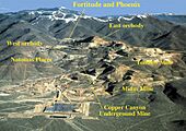
Gold and copper mines in the Battle Mountain Mining District. As of 2019, the mines are operated by Newmont Goldcorp as the Phoenix Mine.
-
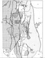
Battle Mountain Geology Map
-
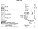
Battle Mountain Geology Map Index


The Battle Mountain Meteorite
On August 22, 2012, a meteorite fall was reported on Battle Mountain. A piece of this meteorite, weighing about 1.4 pounds (630 grams), was sent to NASA for study. Scientists found it was a common type of meteorite called an ordinary chondrite.
Weather in Battle Mountain
Battle Mountain has a cool, dry climate. It gets just enough rain to avoid being a desert. Because it is dry and high up, the temperature can change a lot between day and night. This is especially true in summer.
In January, the average temperature is about 29.8°F (–1.2°C). In July, it is about 73.6°F (23.1°C). On average, the temperature reaches 100°F (38°C) or hotter about 14 days a year. It can also drop to 0°F (–18°C) or colder about seven mornings a year. The coldest temperature ever recorded was –39°F (–39°C) in December 1990. The hottest was 112°F (44°C) in July 2002.
Battle Mountain gets about 19.1 inches (48.5 cm) of snow each year. Most of this snow falls in December and January.
| Climate data for Battle Mountain 4 SE, Nevada (1971 to 2000) | |||||||||||||
|---|---|---|---|---|---|---|---|---|---|---|---|---|---|
| Month | Jan | Feb | Mar | Apr | May | Jun | Jul | Aug | Sep | Oct | Nov | Dec | Year |
| Record high °F (°C) | 67 (19) |
72 (22) |
80 (27) |
90 (32) |
97 (36) |
104 (40) |
109 (43) |
106 (41) |
102 (39) |
95 (35) |
80 (27) |
67 (19) |
109 (43) |
| Mean daily maximum °F (°C) | 42.8 (6.0) |
50.0 (10.0) |
57.7 (14.3) |
65.3 (18.5) |
74.6 (23.7) |
85.9 (29.9) |
95.8 (35.4) |
94.6 (34.8) |
84.4 (29.1) |
70.9 (21.6) |
53.5 (11.9) |
43.6 (6.4) |
68.3 (20.2) |
| Mean daily minimum °F (°C) | 16.8 (−8.4) |
22.2 (−5.4) |
27.1 (−2.7) |
30.9 (−0.6) |
38.9 (3.8) |
45.8 (7.7) |
51.4 (10.8) |
48.8 (9.3) |
40.3 (4.6) |
30.2 (−1.0) |
23.1 (−4.9) |
16.1 (−8.8) |
32.6 (0.3) |
| Record low °F (°C) | −35 (−37) |
−25 (−32) |
−3 (−19) |
8 (−13) |
14 (−10) |
24 (−4) |
31 (−1) |
28 (−2) |
11 (−12) |
3 (−16) |
−9 (−23) |
−39 (−39) |
−39 (−39) |
| Average precipitation inches (mm) | 0.86 (22) |
0.68 (17) |
0.85 (22) |
0.91 (23) |
1.30 (33) |
0.77 (20) |
0.28 (7.1) |
0.34 (8.6) |
0.68 (17) |
0.67 (17) |
0.71 (18) |
0.72 (18) |
8.77 (222.7) |
| Average snowfall inches (cm) | 5.4 (14) |
3.1 (7.9) |
2.3 (5.8) |
1.3 (3.3) |
0.1 (0.25) |
trace | 0.0 (0.0) |
0.0 (0.0) |
trace | 0.4 (1.0) |
1.9 (4.8) |
4.6 (12) |
19.1 (49) |
| Average precipitation days (≥ 0.01 in) | 7.1 | 7.0 | 7.5 | 7.1 | 7.5 | 4.7 | 2.3 | 2.7 | 3.6 | 4.3 | 6.6 | 6.2 | 66.6 |
| Average snowy days (≥ 0.1 in) | 3.2 | 2.3 | 1.6 | 0.9 | 0.1 | 0.0 | 0.0 | 0.0 | 0.0 | 0.2 | 1.5 | 2.4 | 12.2 |
| Source 1: National Oceanic and Atmospheric Administration | |||||||||||||
| Source 2: National Weather Service, Elko | |||||||||||||
Who Lives in Battle Mountain?
| Historical population | |||
|---|---|---|---|
| Census | Pop. | %± | |
| 2020 | 3,705 | — | |
| U.S. Decennial Census | |||
In 2020, the population of Battle Mountain was 3,705 people. This was a small increase from 3,635 people in 2010.
In 2000, there were 2,871 people living in Battle Mountain. Most people were White (81.30%). About 11.81% were from other races. About 23.58% of the population were Hispanic or Latino.
Many households (41.9%) had children under 18 living with them. The average household had 2.71 people. The average family had 3.28 people.
About 33.8% of the people were under 18 years old. The median age was 32 years. This means half the people were younger than 32, and half were older.
Fun Things to Do in Battle Mountain
Battle Mountain has a public library. It is part of the Elko-Lander-Eureka County Library System.
Exciting Bike Races
Battle Mountain hosts an exciting annual bike race. It takes place on a long, flat part of Highway 305. Teams from all over the world come to try and pedal the fastest bicycles on Earth. This event is called the "World Human Powered Speed Challenge."
In 2016, Todd Reichert became "the fastest man alive" on a bicycle. He pedaled a special streamlined bike at 89.59 miles per hour (144.18 km/h). He set five new records that week.
In 2019, Ilona Peltier from France became "the fastest woman alive." She set the world record for women's bicycle speed at 78.61 miles per hour (126.51 km/h).
The Pony Express Race
Another annual event on the same road is the "Pony Express" race. This is an open road race from Battle Mountain to Austin and back. It is the longest open road race in the country, covering about 130 miles (209 km). Many different types of cars take part, from old muscle cars to modern sports cars.
Learning in Battle Mountain
Public schools in Battle Mountain are managed by the Lander County School District. The district operates Battle Mountain High School.
Getting Around Battle Mountain

Battle Mountain is located along Interstate 80. This highway is about halfway between Reno and Salt Lake City, Utah.
Nevada State Route 305 starts in Battle Mountain and goes south to Austin.
The Union Pacific Railroad line also runs through Battle Mountain.
There is a public airport called Battle Mountain Airport. It is also known as Lander County Airport. This airport is about 3 miles (4.8 km) southeast of the town center.
Famous People from Battle Mountain
- Joyce Collins, a jazz pianist, singer, and teacher.
- Mary Dann and Carrie Dann, who were activists for the Western Shoshone people's rights.
- Jeannette Walls, a well-known author.
Battle Mountain's National Recognition
In 2001, a newspaper article called Battle Mountain the "Armpit of America." The town decided to use this nickname for fun! From 2002 to 2005, they held an annual "Armpit Festival." A company even sponsored it and gave out deodorant-themed prizes.
In 2009, The New York Times wrote an article about Battle Mountain. It talked about how the town's economy was doing well because of gold mining, even during a tough time for the country.
See also
 In Spanish: Battle Mountain para niños
