
Battle Mountains, Nevada facts for kids
Quick facts for kids Battle Mountains, Nevada |
|
|---|---|

Location in Nevada
|
|
| Highest point | |
| Peak | North Peak (Humboldt County) |
| Elevation | 2,606 m (8,550 ft) |
| Dimensions | |
| Length | 24 km (15 mi) N-S |
| Width | 22 km (14 mi) E-W |
| Area | 337 km2 (130 sq mi) |
| Geography | |
| Country | United States |
| State | Nevada |
| Range coordinates | 40°37′2″N 117°7′12″W / 40.61722°N 117.12000°W |
| Borders on | Fish Creek Range SW and Shoshone Range SE |
| Topo map | USGS Antler Peak, Galena Canyon, North Peak, and Snow Gulch, Nevada 7.5 Minute Quads |
The Battle Mountains are a group of mountains in Nevada, a state in the western United States. They are found in the western part of Lander County and the southeastern part of Humboldt County.
Two towns, Battle Mountain and Valmy, are located near these mountains. Battle Mountain is to the east, and Valmy is to the north. Both towns are along Interstate 80, which is a major highway. The Humboldt River flows through this area. A road called Nevada State Route 305 also runs along the southeast side of the mountains.
The Battle Mountains are shaped a bit like a circle. Rivers and streams flow outwards from the center, like spokes on a wheel. The Humboldt River Valley is to the northeast. Other nearby mountain ranges include the Sheep Creek Range to the northeast, the Tobin Range to the northwest, and the Fish Creek Range to the southwest.
Tallest Spots
The Battle Mountains have several named peaks, which are like the highest points or summits. Here are some of them:
| Peak | Peak elevation | Coordinates |
| North Peak | 8,550 ft (2,610 m) | 40° 40′ 31″ N 117° 08′ 00″ W |
| Antler Peak | 8,236 ft (2,510 m) | 40° 35′ 57″ N 117° 08′ 03″ W |
| Long Peak | 7,870 ft (2,400 m) | 40° 37′ 08″ N 117° 06′ 08″ W |
| Chessor Mountain | 6,018 ft (1,834 m) | 40° 31′ 59″ N 117° 06′ 09″ W |
| Elephant Head | 5,930 ft (1,810 m) | 40° 36′ 42″ N 117° 01′ 09″ W |
Mining History
The Battle Mountains have a long and interesting history of mining. People first discovered valuable minerals here in 1866. The earliest mining activities took place around a place called Copper Basin. This area was about 5.4 miles (8.7 km) west of where the town of Battle Mountain is today.
The original mining camp for Battle Mountain was in Copper Basin. Later, the camp moved to its current location by the Humboldt River. This new spot became a town that helped support the miners. Other mining camps, like Bannock, Copper Canyon, and Galena, were later built in Galena Canyon. The Bannock camp started in 1909.
Miners in the Battle Mountains found many different types of valuable materials. These included copper, gold, silver, and lead. They also found zinc, tungsten, and molybdenum. Other minerals like antimony, arsenic, turquoise, and nickel were also discovered. Today, the Marigold Gold mine is still active in the northern part of the mountains.
Images for kids
-
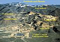
Mines of the Copper Canyon area

