Rochester, Nevada facts for kids
Quick facts for kids
Rochester
|
|
|---|---|

Upper Rochester, Nevada
|
|
| Country | United States |
| State | Nevada |
| County | Pershing |
| Elevation | 6,716 ft (2,047 m) |
| Time zone | UTC-8 (Pacific (PST)) |
| • Summer (DST) | UTC-7 (PDT) |
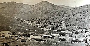
Rochester was once a busy silver-mining town in Nevada, USA. It was about 110 miles east of Reno. Today, it is a ghost town, meaning it's mostly abandoned. You can still visit parts of Lower Rochester, but a wildfire damaged it in 2012. Upper Rochester is now covered by piles of rock and waste from a large modern mine.
Contents
The History of Rochester
Rochester is actually the name for three different places. These are Rochester Heights, Upper Rochester, and Lower Rochester. They are spread out over a 3-mile area in Rochester Canyon.
Early Discoveries and the Boom Town
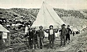
In the 1860s, people from Rochester, New York found gold here. At first, there was only one camp at the top of the canyon. This camp later became known as Rochester Heights. Sometimes, Rochester Heights and Upper Rochester were called "Old Town."
Mining was small-scale in the 1860s. Miners processed the ore in small amounts. Sometimes, they shipped it by wagon to bigger towns for milling.
A big change happened in 1912. A man named Joseph Nenzel found a lot of rich silver ore. This discovery turned Rochester into a true "boom town." A boom town is a place that grows very quickly because of a sudden increase in business.
By November 1912, news of the silver find spread fast. Many people rushed to the area. The town grew, and Upper Rochester was built. Lower Rochester also started to form. Rochester Heights was soon grouped with Upper Rochester, and together they were called Old Town. Lower Rochester was the new part of town.
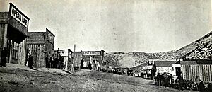
Rochester Canyon is narrow with steep sides. Because of this, the camps grew longer down the canyon instead of wider. As more people arrived, both camps soon had saloons, hotels, and other businesses. Upper and Lower Rochester became busy mining sites. Their population grew to over 1,500 people.
Most of the shops and businesses were in Upper Rochester. Lower Rochester had the mill and other buildings to support the mining work. The town even had its own group of musicians, called The Rochester Philharmonic Orchestra.
The Nevada Short Line Railway
In 1914, the Nevada Short Line Railway built tracks from Oreana. Oreana was east of Rochester. The railway already went into Limerick Canyon from Oreana. A new track was added that went into Rochester Canyon. It reached as far as Lower Rochester.
By August 1915, the railway extended its tracks further up the canyon. It went through Upper Rochester to reach the mine. The plan was to use the train to carry ore down to the mills in Lower Rochester.
However, the railroad was not very reliable. It had problems with old locomotives, fires, and accidents. The railway's management also had issues. It went bankrupt in late 1915. A judge gave it one more chance to make money. The railway tried to run on time through 1915 and 1916. But the mines were not happy with the service.
The Tramway and Decline
Finally, in September 1916, the mine decided to build its own tramway. A tramway is like a cable car system used to move materials. This tramway would carry ore from the mines down to the mill in Lower Rochester. By mid-1917, the tramway was working. This meant the Nevada Short Line Railway was no longer needed. It went bankrupt again in 1918. By 1919, it closed completely, and its equipment was sold. The train tracks were removed by 1920.
Even with transportation problems, mining continued. The mine operated until 1942. It produced over $9 million worth of silver and gold.
However, Rochester as a town slowly began to shrink after 1922. By 1926, the post office closed. Many businesses also shut down. After 1942, the mine often closed for long periods. It only opened when silver and gold prices were high enough. Most people had left the area by 1951. Only a few people stayed, living on and off in the remaining buildings.
Modern Mining and What Remains
In 1986, Coeur d'Alene Mines started a new, large-scale mining operation. This was an open-pit mine on Nenzel Hill. This new mine, called Coeur Rochester, has covered almost all of Upper Rochester with large piles of mine waste.
Lower Rochester still has many old building foundations. Some wooden structures also remain, including parts of a large mill building. You can also still see the wooden towers from the old tramway on the hillside. The path of the old Nevada Short Line railway can be followed through much of the canyon.
How to Visit Rochester
Rochester is located about 110 miles east of Reno. It sits at an elevation of 5,563 feet. To get there, take Interstate 80. From the interstate, turn southeast onto a dirt road. Follow this dirt road for about 10.2 miles to reach the Lower Rochester town site.
 | William M. Jackson |
 | Juan E. Gilbert |
 | Neil deGrasse Tyson |


