Imlay, Nevada facts for kids
Quick facts for kids
Imlay, Nevada
|
||
|---|---|---|

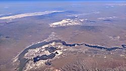
Imlay (at lower right) is near the Lassens Meadows, above Rye Patch Reservoir, on the Humboldt River.
|
||
|
||
| Country | United States | |
| State | Nevada | |
| Area | ||
| • Total | 1.18 sq mi (3.06 km2) | |
| • Land | 1.18 sq mi (3.06 km2) | |
| • Water | 0.00 sq mi (0.00 km2) | |
| Elevation | 4,203 ft (1,281 m) | |
| Population
(2020)
|
||
| • Total | 210 | |
| • Density | 177.66/sq mi (68.58/km2) | |
| Time zone | UTC-8 (Pacific (PST)) | |
| • Summer (DST) | UTC-7 (PDT) | |
| ZIP code |
89418
|
|
| Area code(s) | 775 | |
| FIPS code | 32-34700 | |
| GNIS feature ID | 0841225 | |
Imlay is a small, unincorporated town in Pershing County, Nevada, United States. This means it's a community that isn't officially part of a city or town government.
Imlay has a few important places like an elementary school, a general store, and a post office. In 2010, about 171 people lived here. By 2020, the population grew slightly to 210.
This town was once a busy railroad stop. It was named either after a nearby mine or a civil engineer who helped survey the area around 1907.
One of the most interesting things about Imlay is Thunder Mountain Monument. These are unique buildings created by a World War II veteran. He called himself Thunder and built these structures to honor Native American culture.
The public radio show Whad'Ya Know? even featured Imlay as their "Town of the Week" in 2009. They highlighted Thunder Mountain Monument as a main reason to visit the area.

Where is Imlay Located?
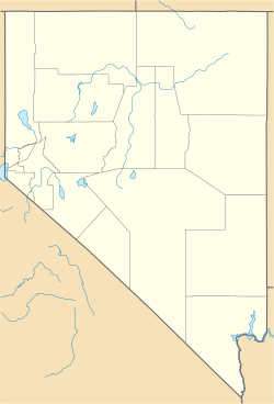
Imlay is found in the northern part of Nevada, in Pershing County. You can easily reach it from Interstate 80 at Exit 145.
The town is about 34 miles (55 km) west of Winnemucca. It's also about 40 miles (64 km) northeast of Lovelock. The Humboldt River flows about 2 miles (3.2 km) north of Imlay. This river feeds into the nearby Rye Patch Reservoir.
According to the U.S. Census Bureau, the area of Imlay is about 1.18 square miles (3.06 square kilometers). All of this area is land.
Imlay's Climate and Weather
Imlay has a type of weather called a cold semi-arid climate. This means it's generally dry, but not as dry as a desert, and it can get quite cold.
The hottest temperature ever recorded in Imlay was 112°F (44°C) on July 17, 1959. The coldest temperature was a chilly -35°F (-37°C), which happened on January 17, 1917, and again on December 25, 1924.
| Climate data for Imlay, Nevada, 1991–2020 normals, extremes 1914–present | |||||||||||||
|---|---|---|---|---|---|---|---|---|---|---|---|---|---|
| Month | Jan | Feb | Mar | Apr | May | Jun | Jul | Aug | Sep | Oct | Nov | Dec | Year |
| Record high °F (°C) | 70 (21) |
76 (24) |
82 (28) |
90 (32) |
99 (37) |
108 (42) |
112 (44) |
106 (41) |
104 (40) |
98 (37) |
82 (28) |
78 (26) |
112 (44) |
| Mean maximum °F (°C) | 56.9 (13.8) |
63.0 (17.2) |
72.1 (22.3) |
79.8 (26.6) |
88.3 (31.3) |
96.4 (35.8) |
101.4 (38.6) |
99.4 (37.4) |
93.4 (34.1) |
83.0 (28.3) |
68.6 (20.3) |
58.3 (14.6) |
102.1 (38.9) |
| Mean daily maximum °F (°C) | 41.6 (5.3) |
47.5 (8.6) |
56.1 (13.4) |
61.6 (16.4) |
71.1 (21.7) |
81.5 (27.5) |
92.0 (33.3) |
90.1 (32.3) |
80.6 (27.0) |
66.6 (19.2) |
51.6 (10.9) |
40.7 (4.8) |
65.1 (18.4) |
| Daily mean °F (°C) | 30.7 (−0.7) |
35.3 (1.8) |
42.0 (5.6) |
47.3 (8.5) |
56.4 (13.6) |
65.8 (18.8) |
74.8 (23.8) |
71.9 (22.2) |
62.6 (17.0) |
49.6 (9.8) |
37.7 (3.2) |
29.4 (−1.4) |
50.3 (10.2) |
| Mean daily minimum °F (°C) | 19.9 (−6.7) |
23.2 (−4.9) |
27.9 (−2.3) |
33.1 (0.6) |
41.8 (5.4) |
50.1 (10.1) |
57.7 (14.3) |
53.7 (12.1) |
44.5 (6.9) |
32.7 (0.4) |
23.7 (−4.6) |
18.0 (−7.8) |
35.5 (2.0) |
| Mean minimum °F (°C) | 2.4 (−16.4) |
8.3 (−13.2) |
14.2 (−9.9) |
19.3 (−7.1) |
27.6 (−2.4) |
35.0 (1.7) |
46.7 (8.2) |
41.9 (5.5) |
30.4 (−0.9) |
17.5 (−8.1) |
7.3 (−13.7) |
−1.8 (−18.8) |
−4.9 (−20.5) |
| Record low °F (°C) | −35 (−37) |
−28 (−33) |
−5 (−21) |
10 (−12) |
17 (−8) |
26 (−3) |
28 (−2) |
29 (−2) |
16 (−9) |
2 (−17) |
−6 (−21) |
−35 (−37) |
−35 (−37) |
| Average precipitation inches (mm) | 0.92 (23) |
0.83 (21) |
1.16 (29) |
0.96 (24) |
1.08 (27) |
0.56 (14) |
0.20 (5.1) |
0.19 (4.8) |
0.27 (6.9) |
0.63 (16) |
0.66 (17) |
0.93 (24) |
8.39 (211.8) |
| Average snowfall inches (cm) | 2.9 (7.4) |
1.2 (3.0) |
1.8 (4.6) |
0.8 (2.0) |
0.0 (0.0) |
0.0 (0.0) |
0.0 (0.0) |
0.0 (0.0) |
0.0 (0.0) |
0.0 (0.0) |
0.8 (2.0) |
4.1 (10) |
11.6 (29) |
| Average precipitation days (≥ 0.01 in) | 6.6 | 6.5 | 6.4 | 6.5 | 6.5 | 3.0 | 1.9 | 1.6 | 2.0 | 3.6 | 4.4 | 6.6 | 55.6 |
| Average snowy days (≥ 0.1 in) | 1.9 | 1.4 | 1.0 | 0.6 | 0.0 | 0.0 | 0.0 | 0.0 | 0.0 | 0.1 | 0.9 | 3.0 | 8.9 |
| Source 1: NOAA | |||||||||||||
| Source 2: National Weather Service | |||||||||||||
Imlay's Population
The number of people living in a place is called its population. This information is often collected during a census.
| Historical population | |||
|---|---|---|---|
| Census | Pop. | %± | |
| 2020 | 210 | — | |
| U.S. Decennial Census | |||
In 2010, the population of Imlay was 171 people. By the 2020 census, the population had grown to 210 people.
See also
 In Spanish: Imlay (Nevada) para niños
 | Kyle Baker |
 | Joseph Yoakum |
 | Laura Wheeler Waring |
 | Henry Ossawa Tanner |


