Maggie Creek (Humboldt River tributary) facts for kids
Quick facts for kids Maggie Creek |
|
|---|---|

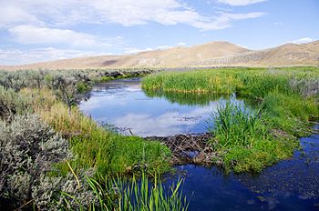
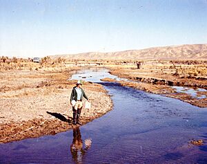
Maggie Creek in 2011 reveals beaver dam and transformation from 1980 photo below. Courtesy Elko District, BLM.
|
|
| Other name(s) | Martins Fork of Humboldt River |
| Country | United States |
| State | Nevada |
| Region | Elko and Eureka Counties |
| City | Carlin, Nevada |
| Physical characteristics | |
| Main source | The north side of Independence Mountain 6,760 ft (2,060 m) 38°27′23″N 122°30′25″W / 38.45639°N 122.50694°W |
| River mouth | 4,895 ft (1,492 m) 41°11′44″N 116°00′26″W / 41.19556°N 116.00722°W |
Maggie Creek is a stream in northeastern Nevada. It flows south for about 85 miles (137 km). The creek starts in the Independence Mountains. It then joins the Humboldt River near Carlin in Elko County.
Contents
History of Maggie Creek
On older maps, Maggie Creek was known by other names. These included Robin's Creek or Martin's Fork. The name "Maggie Creek" came from a Scottish family. They were traveling to California in 1849. This family camped near the stream. They named four creeks after their four daughters. These creeks were Maggie Creek, Susie Creek, Mary Creek, and Amelia Creek.
Understanding the Maggie Creek Watershed
A watershed is an area of land. All the rain and snowmelt in this area drains into one river or stream. The Maggie Creek watershed covers about 400 square miles (1,036 km²). It is surrounded by mountains. The Tuscarora Mountains are to the west. The Independence Mountains are to the north and east. Most of the water for Maggie Creek comes from snow melting in the Tuscarora Mountains. This water flows into Maggie Creek through smaller streams. These include Beaver Creek, Coyote Creek, Little Jack Creek, and Jack Creek.
Gold and Geology Around Maggie Creek
The land under the Maggie Creek watershed is special. It sits on something called the Carlin Trend. This is a long area, about 50 miles (80 km) long and 5 miles (8 km) wide. It is famous for having a lot of gold. People call it the biggest goldfield in the Western Hemisphere.
Newmont Mining Corporation started mining gold here in 1965. This was in the lower part of the Maggie Creek watershed. Later, they found even more gold deeper underground. So, they started underground mining in 1994. This mining needed water to be removed from the ground. The money from this helped fund the Maggie Creek Watershed Project. This project helps to keep Maggie Creek healthy.
Ecology and Wildlife in Maggie Creek
Maggie Creek and Susie Creek flow into the Humboldt River. Over the past 20 years, many groups have worked together. Ranchers, government agencies, mining companies, and non-profit groups helped. They improved how cattle graze near the creeks. They also did specific projects. These projects helped the creeks become healthier.
Bringing Back Lahontan Cutthroat Trout
One big success was the return of Lahontan cutthroat trout. These fish are a special type of trout. They are native to this area. Before 1993, cattle often grazed along the creek all year. This damaged the areas where fish lived. New rules were put in place. These rules limited when and where cattle could graze. This helped the creek's banks recover.
The trout need to move freely to different parts of the creek. This helps them grow, find mates, and escape danger. Some culverts (tunnels under roads) were blocking their path. In 2005, these culverts were replaced. They were made so fish could swim through them easily. An irrigation dam was also changed. These changes reconnected three smaller streams to Maggie Creek. This allowed the trout to move around more. In 2012, a large barrier was built. This barrier stops non-native fish from entering the restored area. This helps protect the native trout.
Beavers Helping the Creek Recover
North American beaver are also making a comeback in Elko County. This might be because less fur trapping is happening. Also, cattle are eating less of the plants near the water. Beavers build dams. These dams help the creek in many ways.
- In 2006, there were 107 beaver dams along 20 miles (32 km) of Maggie Creek.
- By 2010, this number grew to 271 dams.
Beaver dams slow down the water. They also collect sediment (dirt and sand). This sediment used to be washed away downstream. Now, it helps to widen the green areas along the creek. In just five years, beaver ponds have increased the amount of water held in Maggie Creek. The water in these ponds seeps into the ground. This raises the water level underground. Monitoring wells show that the groundwater level has risen about 2 feet (0.6 meters). This means more water is available for wildlife and livestock. It also helps protect the native trout populations.
 | John T. Biggers |
 | Thomas Blackshear |
 | Mark Bradford |
 | Beverly Buchanan |


