
East Humboldt Range facts for kids
Quick facts for kids East Humboldt Range |
|
|---|---|

The East Humboldt Range, looking northwest from Spruce Mountain
|
|
| Highest point | |
| Peak | Hole in the Mountain Peak |
| Elevation | 3,446 m (11,306 ft) |
| Geography | |

Location in Nevada
|
|
| Country | United States |
| State | Nevada |
| County | Elko County |
| Range coordinates | 40°55′16.724″N 115°7′7.177″W / 40.92131222°N 115.11866028°W |
| Topo map | USGS Humboldt Peak |
The East Humboldt Range is a beautiful group of mountains in Elko County, Nevada, United States. These mountains are found near the eastern side of the Humboldt River, which starts just north of them. The highest point in the range is Hole in the Mountain Peak, which stands tall at 11,306 feet (3,446 m).
Much of this area is part of the Humboldt-Toiyabe National Forest. In 1989, a large part of the range, over 36,000 acres (150 km2), became the East Humboldt Wilderness. This means it's a special protected area where nature is protected. The mountains are named after the Humboldt River, which itself was named after a famous German scientist, Alexander von Humboldt.
Contents
Where are the East Humboldt Mountains?
The East Humboldt Mountains stretch for about 30 miles (48 km) from north to south. To the north, you'll find Interstate 80 and the town of Wells. To the south, there's Secret Pass and the larger Ruby Range.
On the eastern side, you can see Clover Valley and U.S. Route 93. To the west are Starr Valley and Dennis Flats.
How These Mountains Were Formed
These mountains were created by a process called "fault-block" formation. Imagine a giant block of land tilting! This created gentle slopes and valleys on the west side. The eastern side has a very steep cliff, called an escarpment.
Both sides of the range show clear signs of glaciation. This means huge sheets of ice, or glaciers, moved across the land during past ice ages. They carved out U-shaped canyons and left behind piles of rock and dirt called moraines. You can also see sharply carved granite peaks, cliffs, and bowl-shaped hollows called cirques. Many of these features are visible from the 12 mi (19 km) paved road from Wells to Angel Lake.
Mountain Peaks and High Points
The range starts with a big climb from near the Humboldt River and the town of Wells. The elevation there is about 5,650 feet (1,720 m). It quickly rises to the top of Greys Peak at 10,674 feet (3,253 m).
From Greys Peak, the mountains continue south for almost 10 miles (16 km) as a high ridge. Most of this ridge stays above 10,000 feet (3,000 m). The very center of this high ridge includes the highest point in the range, Hole in the Mountain Peak. The southernmost tall peak is Humboldt Peak, standing at 11,020 ft (3,360 m). After this, the main ridge slowly slopes down towards Secret Pass.
Beautiful Lakes and Hiking Trails
The East Humboldt Range is home to many beautiful lakes. These lakes are called tarns, and they were formed by glaciers during the ice ages. Some of the lakes in the northern part of the range include Angel Lake, Smith Lake, Greys Lake, and Winchell Lake. In the central part, you'll find Lizzie's Basin, Boulder Lakes, and Steele Lake.
There are many hiking trails for you to explore these mountains. Trails run from Secret Pass up the western side of the range all the way to Angel Lake. You can also hike from Angel Lake to nearby Smith Lake. Another trail goes from Angel Lake down the east side of the range to Winchell Lake and Lizzie's Basin. The easiest ways to get into the mountains are at Angel Lake, a trailhead at the west end of Secret Pass, and a rough road at Weeks Canyon/Lizzie's Basin.
Images for kids
-
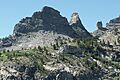
Chimney Rock, above Angel Lake
-
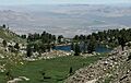
Smith Lake (with Wells in the distance)
-
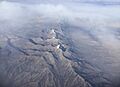
View of the range from an airplane


