
Clover Valley (Nevada) facts for kids
Quick facts for kids Clover Valley (Nevada) |
|
|---|---|

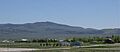
View of Clover Valley, Nevada from Spruce Mountain
|
|

Clover Valley (Nevada)
Location in Nevada
|
|
| Length | 37 mi (60 km) N-S |
| Width | 20 mi (32 km) |
| Geography | |
| Country | United States |
| State | Nevada |
| Region | Great Basin |
| County | Elko |
| Population center | Wells |
| Borders on |
List
|
| Lake | Snow Water Lake |
The Clover Valley is a long valley in Nevada, USA. It stretches about 37 miles (60 km) from north to south. You can find it in the central-southeast part of Elko County. The town of Wells is at its northern end, right by I-80.
This valley sits next to the East Humboldt Range mountains. Many small streams flow from these mountains into the northern part of the valley. These mountain forests are part of the Humboldt-Toiyabe National Forest. In the north, there's a marshy area that drains south into a lake called Snow Water Lake. This lake sometimes dries up.
Contents
What Does Clover Valley Look Like?
Clover Valley runs mainly from north to south. The Wood Hills are along its northeast and eastern sides. These hills are southeast of the town of Wells. Further to the south-southeast, you'll find Spruce Mountain.
Around Snow Water Lake, which is in the middle of the valley, the land is mostly flat. The only exception is on its western side, where the foothills of the East Humboldt Range meet the lake.
A Glimpse into Clover Valley's Past
The first people to settle permanently in Clover Valley arrived in 1864. There was once a train station here for the Western Pacific Railroad. It was located between Ventosa and Wells.
The station got its name from a sign pointing to a local bar. The sign was written roughly, and people read it as "TOBAR." A post office opened here, first called Clover City. It changed to Tobar on December 20, 1911. Then, it became Clover City again on December 11, 1918. The name Tobar was used again from January 18, 1921, until the post office closed on September 17, 1942.
How to Get to Clover Valley
U.S. Route 93 goes through the western part of the valley. It starts near Wells and heads south. It passes the southern end of the East Humboldt Range at Warm Creek Ranch. Route 93 then continues southeast towards Currie in Goshute Valley.
If you're coming from the west, Nevada State Route 229 connects from northern Ruby Valley to US 93. This connection is south of Warm Creek Ranch. In the northwest, south of Wells, Nevada 232 follows the foothills. This area is west of the marshy region, where about fifteen creeks flow down from the East Humboldt Range. Most other parts of the valley can only be reached by unpaved roads. The northern edge of the valley is roughly where Interstate 80 travels east from Wells.
Images for kids
-
View southeast of Wood Hills from Wells

