
Ruby Valley facts for kids

Ruby Valley is a big, open area of land in the northeastern part of Nevada, a state in the western United States. It stretches for about 60 miles (96 km) from north to south. On its west side, you can see the tall, steep Ruby Mountains. To the north are the East Humboldt Range and Clover Valley. The valley is about 10 miles (16 km) wide at its widest point, near Franklin Lake. At the very south end of the valley is the Ruby Lake National Wildlife Refuge, a special place for animals.
You can drive through parts of Ruby Valley on SR 229 and Ruby Valley Road (SR 767 and CR 788). Another road, Harrison Pass Road (CR 718), crosses the Ruby Mountains right in the middle of the valley. Most of Ruby Valley is about 6,000 feet (1,820 meters) above sea level.
Contents
Ruby Valley: A Special Place in Nevada
Ruby Valley has been an important place for a very long time. It has a rich history, from ancient Native American tribes to famous mail routes and military forts.
A Look Back in Time: History of Ruby Valley
Ruby Valley played a big role in the history of the Great Basin region. Many different groups of people have used and traveled through this area over hundreds of years.
Native American Life in Ruby Valley
Long ago, Shoshone people, who were nomadic (meaning they moved from place to place), used Ruby Valley as a winter home. They found it warmer here than in other nearby areas. This valley provided them with resources they needed to survive the cold months.
The California Trail and Early Travelers
After the 1840s, the California Trail became a popular path for people traveling west. This trail was located just north of Ruby Valley. In 1846, a famous group called the Donner Party traveled through the southern part of the valley. They were trying to cross the Ruby Mountains using a route called the Hastings Cutoff.
The Pony Express and Fort Ruby
The 1860s were a busy time around Overland Pass, which is at the south end of Ruby Valley. In 1855, a route through central Nevada was explored. Then, in 1859, Captain James H. Simpson surveyed it for the U.S. Army. He set up a trading post there.
In 1860, George Chorpenning built a station for his mail and stagecoach line. The famous Pony Express, which delivered mail on horseback, also used this route. Later, the Transcontinental Telegraph line, which sent messages across the country, also passed through Overland Pass.
In September 1862, the U.S. Government built Fort Ruby at the east entrance to the pass. This fort was built to protect settlers and the important communication lines (like the Pony Express and telegraph) during the American Civil War. In 1863, the government signed the Treaty of Ruby Valley with the Western Shoshone people. This agreement allowed people to use the land but did not mean the Shoshone gave up ownership of it.
What Happened Next?
After the American Civil War, companies like Wells Fargo continued to provide transportation services across the West. Around 1866, Wells Fargo started farming in Ruby Valley to help supply their stations.
However, in the late 1860s, the Transcontinental Railroad was built much further north. This meant that Overland Pass and the routes through Ruby Valley were not used as much anymore. Fort Ruby closed in September 1869, only seven years after it was built.
In more recent times, the old Pony Express Station was moved and fixed up. You can now see it at the Northeastern Nevada Museum in Elko. Today, fewer people live in the valley. The land is mostly used for large farms and ranches where people raise cattle and grow alfalfa, a type of plant used for animal feed.
Images for kids
-
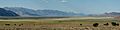
Ruby Valley, looking north from near Overland Pass


