Greys Peak facts for kids
Quick facts for kids Greys Peak |
|
|---|---|

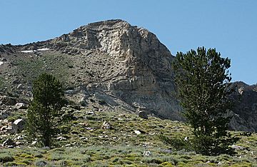
Greys Peak, looking northwest
|
|
| Highest point | |
| Elevation | 10,676 ft (3,254 m) NAVD 88 |
| Prominence | 714 ft (218 m) |
| Geography | |
| Parent range | East Humboldt Range |
| Topo map | USGS Welcome |
| Climbing | |
| Easiest route | Scramble, class 2 |
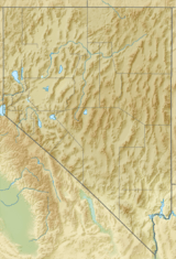
Greys Peak is a tall mountain located in northeastern Nevada, USA. It is the northernmost peak in the East Humboldt Range within Elko County. This impressive mountain stands about 10 miles (16 kilometers) southwest of the town of Wells.
Greys Peak rises more than 5,000 feet (about 1,500 meters) from the Humboldt Valley. This makes it one of the most easily seen and prominent mountains in the area. To the west of the peak, you can find places like Dennis Flats, Starr Valley, and the quiet Greys Lake. To the east are Chimney Rock, Clover Valley, and the popular Angel Lake. The summit of Greys Peak is also the start of a high ridge that stretches almost 10 miles (16 kilometers) to the south.
Naming the Peak
Greys Peak got its name from an early settler named Enoch Grey. He was one of the first people to build a home and farm in the nearby Starr Valley. Naming natural features after important local figures was a common practice in the past.
Exploring Greys Peak
This mountain offers amazing views and a chance to experience nature. Around Greys Peak, you can find different types of landscapes. There are flat areas, valleys, and beautiful lakes. These areas are home to various plants and animals.
Getting to the Summit
The most common way to climb Greys Peak starts at the Angel Lake Campground. This campground is located on the western side of the mountain. From the parking lot, a basic trail leads climbers upwards.
The climb involves gaining about 2,300 feet (700 meters) in elevation. The route is considered a "scramble," which means it's not a difficult rock climb but might require using your hands for balance. It is rated as a Class 2 climb on the Yosemite Decimal System (YDS). This means the trail is mostly walking, but there might be some uneven ground or small rocks where you need to use your hands to keep steady.
 | Isaac Myers |
 | D. Hamilton Jackson |
 | A. Philip Randolph |


