Humboldt Peak (Nevada) facts for kids
Quick facts for kids Humboldt Peak |
|
|---|---|

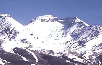
Humboldt Peak, looking north
|
|
| Highest point | |
| Elevation | 11,025 ft (3,360 m) NAVD 88 |
| Prominence | 860 ft (262 m) |
| Geography | |
| Parent range | East Humboldt Range |
| Topo map | USGS Humboldt Peak |
| Climbing | |
| Easiest route | From ridge above Steele Lake: Hike & Scramble |
Humboldt Peak is a tall mountain in the East Humboldt Range in northeastern Nevada. It is the most southern high point in this mountain range. The peak is found in Elko County, USA.
This mountain is surrounded by interesting natural features. To the west, you can find First and Second Boulder Canyons. To the south, there is Pole Canyon and Secret Pass. On the east side, you will see the South Fork of Steele Creek and Clover Valley.
Humboldt Peak is the end of a high ridge that stretches for about 16 kilometers (10 miles) to the north. From the peak, the land slowly slopes down towards Ruby Valley in the southeast. It is the fourth highest peak in the East Humboldt Range. The mountain is about 26 kilometers (16 miles) southwest of the town of Wells.
Where is Humboldt Peak Located?
Humboldt Peak is part of the East Humboldt Wilderness. This area is protected for its natural beauty. It is also within the Humboldt National Forest. This forest covers a large part of Nevada.
What Makes Humboldt Peak Special?
Humboldt Peak stands at 11,025 feet (3,360 meters) tall. This makes it a significant landmark in the region. Its location offers views of the surrounding valleys and other mountains.
How Can You Reach the Summit?
The easiest way to reach the top of Humboldt Peak is from the ridge above Steele Lake. This route involves both hiking and scrambling. Scrambling means climbing over rocks using your hands and feet. It is a fun challenge for experienced hikers.
 | Jewel Prestage |
 | Ella Baker |
 | Fannie Lou Hamer |


