
West Humboldt Range facts for kids
Quick facts for kids West Humboldt Range |
|
|---|---|

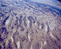
View of Topog Peak and the westernmost part of the West Humboldt Range from U.S. Route 95 near the junction with Interstate 80
|
|
| Highest point | |
| Elevation | 1,876 m (6,155 ft) |
| Geography | |

Location in Nevada
|
|
| Country | United States |
| State | Nevada |
| District | Pershing County and Churchill County |
| Settlement | Lovelock, NV |
| Range coordinates | 40°3′21.680″N 118°21′54.516″W / 40.05602222°N 118.36514333°W |
| Borders on | Humboldt Sink, Humboldt Lake, Carson Sink, Carson Desert, Humboldt River-(west range border) |
| Topo map | USGS Wildhorse Spring |
The West Humboldt Range is a mountain range in the western Great Basin region of the United States. It is located in northwestern Nevada. This range is not very long, but it plays an important role in the local geography.
Contents
Exploring the West Humboldt Range Geography
This mountain range stretches for about 40 miles (64 kilometers). It runs from the southwest to the northeast. You can find it in northern Churchill County and southern Pershing County. The southwest end of the range is about 60 miles (100 kilometers) east-northeast of Reno.
Natural Borders and Waterways
The West Humboldt Range acts like a natural wall. It separates two important areas. On its northwest side, you'll find the Humboldt River and the Humboldt Sink. The Humboldt River ends in a place called Lake Humboldt. On the south and southeast side, the range separates it from the large Carson Sink.
Interstate 80, a major highway, runs along the Humboldt River. This means it follows the northwest side of the mountain range.
Ancient Lakes and Peaks
Long ago, during the last ice age, a huge lake covered much of Nevada. This ancient lake was called Lake Lahontan. The West Humboldt Range stood right along its shore. Even today, you can see the old shorelines and beaches. They look like lines along the sides of the mountains.
Not many peaks in this range have official names. One of the few named peaks is Topog Peak. It is located in northern Churchill County. You can find it near the southwestern end of the range.
Discovering West Humboldt Range History
The West Humboldt Range has an exciting history, especially for dinosaur fans! Scientists have found amazing fossils here.
The Saurian Expedition of 1905
In 1905, a special trip called the Saurian Expedition took place. It was led by a scientist named John C. Merriam. A woman named Annie Alexander helped pay for the trip.
The team explored the mountains, looking for fossils. They focused on the Triassic limestone rocks. These rocks are very old, from a time when dinosaurs were just starting to appear.
Finding Ichthyosaur Fossils
During their expedition, the scientists made an incredible discovery. They found 25 fossils of a creature called an Ichthyosaur. Ichthyosaurs were ancient marine reptiles. They looked a bit like dolphins or fish. They swam in the oceans millions of years ago. Finding so many of these fossils in one place was a big deal!
Images for kids
-
Satellite photo looking south. The Carson Sink is on the right. The small, dark, curved range on its northwest is the West Humboldt Range.

