Malheur River facts for kids
Quick facts for kids Malheur River |
|
|---|---|

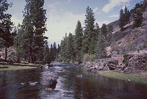
Malheur River flowing through Harney County
|
|
|
Location of the mouth of the Malheur River in Oregon
|
|
| Country | United States |
| State | Oregon |
| County | Malheur, Harney, Grant |
| Physical characteristics | |
| Main source | Blue Mountains Grant County, Oregon 44°8′5″N 118°37′14″W / 44.13472°N 118.62056°W |
| River mouth | Snake River Malheur County, Oregon 2,133 ft (650 m) 44°3′33″N 116°58′31″W / 44.05917°N 116.97528°W |
| Length | 190 mi (310 km) |
| Basin features | |
| Basin size | 4,700 sq mi (12,000 km2) |
| Tributaries |
|
| Type: | Wild, Scenic |
| Designated: | October 28, 1988 |
The Malheur River (pronounced "MAL-hyure") is a river in eastern Oregon, United States. It is about 190 miles (306 km) long. The river flows into the Snake River.
The Malheur River drains a high desert area. This area is located between the Harney Basin and the Blue Mountains. Even though it has a similar name, the Malheur River does not flow into Malheur Lake. Malheur Lake is in a different area called the Harney Basin. In the past, when there was more water, Malheur Lake could drain into the Malheur River.
Contents
Where Does the Malheur River Flow?
The Malheur River starts in the southern Blue Mountains. This is in Grant County, south of Strawberry Mountain. It begins in the Strawberry Mountain Wilderness.
The river flows south through the Malheur National Forest. Then it turns southeast, passing by Drewsey. It also flows through Warm Springs Reservoir.
At Riverside, the river meets the South Fork Malheur River. After this, it turns sharply north towards Juntura. Here, it receives water from the North Fork Malheur River. From Juntura, the river generally flows east past Vale. It joins the Snake River about 2 miles (3 km) north of Ontario, Oregon.
A River with a "Misfortune" Name
The name "Malheur" comes from the French word for "misfortune" or "bad luck." French Canadian fur trappers gave the river this name. They were working for the North West Company in 1818. They had hidden some beaver furs near the river. But Native Americans took the furs, which was bad luck for the trappers.
The name first appeared in records in 1826. A fur trapper named Peter Skene Ogden called it "River au Malheur." This means "River of the Misfortune." Later, he simply called it "Unfortunate River."
The river seemed to live up to its name again in 1845. A mountain man named Stephen Meek tried to find a faster route along the Oregon Trail. He led a group of travelers up the river valley into the high desert. This route became known as the Meek Cutoff.
After leaving the river valley, the group could not find water. Sadly, 23 people died before they reached The Dalles. This town is on the Columbia River.
How the River is Used Today
The lower part of the Malheur River is very important for irrigation. Irrigation is when water is moved to help grow crops. This area is known for growing potatoes. It is part of the Snake River Plain near the Idaho-Oregon border.
There are about 370 miles (595 km) of canals and ditches in the lower Malheur River basin. These are used to move water for irrigation. The river's flow is greatly affected by these systems. They start near Malheur river mile 65, close to Namorf and Harper, Oregon. This system goes all the way downstream to where the Malheur joins the Snake River.
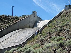
About 132,000 acres (534 km²) of land in the Malheur River basin use irrigation. This irrigation system is part of the Vale Project. The Bureau of Reclamation runs this project. It includes several places where water is stored. The biggest ones are Warm Springs Reservoir on the main Malheur River, Beulah Reservoir on the North Fork Malheur, Bully Creek Reservoir on Bully Creek, and Malheur Reservoir on Willow Creek.
Protecting the Malheur River
The Malheur River watershed was once a major place for fish like salmon to lay their eggs. These fish are called anadromous because they live in the ocean but return to fresh water to reproduce. In the early 1900s, dams built on the Snake River blocked the fish from migrating.
A section of the Malheur River is now protected. About 13.7 miles (22 km) of the river became part of the National Wild and Scenic Rivers System in 1988. This means the area is kept natural and beautiful. This protected area includes about 3,758 acres (15.2 km²) of land along the river.
See also
 In Spanish: Río Malheur para niños
 | William M. Jackson |
 | Juan E. Gilbert |
 | Neil deGrasse Tyson |


