
Vale, Oregon facts for kids
Quick facts for kids
Vale
|
|
|---|---|
| Vale, Oregon | |

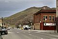
Downtown Vale
|
|
| Motto(s):
Born and raised on the Oregon Trail
|
|

Location in Oregon
|
|
| Country | United States |
| State | Oregon |
| County | Malheur |
| Incorporated | 1889 |
| Area | |
| • Total | 1.14 sq mi (2.94 km2) |
| • Land | 1.14 sq mi (2.94 km2) |
| • Water | 0.00 sq mi (0.00 km2) |
| Elevation | 2,244 ft (684 m) |
| Population
(2020)
|
|
| • Total | 1,894 |
| • Density | 1,668.72/sq mi (644.14/km2) |
| Time zone | UTC-7 (Mountain) |
| • Summer (DST) | UTC-6 (Mountain) |
| ZIP code |
97918
|
| Area code(s) | 541 |
| FIPS code | 41-76600 |
| GNIS feature ID | 1136861 |
| Website | City of Vale |
Vale is a city in Oregon, United States. It is the main town, or county seat, of Malheur County. The city is about 12 miles (19 km) west of the Idaho border. Two important roads, U.S. Routes 20 and 26, meet here. Vale is also located by the Malheur River, where Bully Creek joins it.
In 1888, Vale was chosen as the county seat for Malheur County. Other towns like Ontario and Jordan Valley were also considered. According to the 2010 census, Vale had 1,874 people living there. This was a small decrease from 1,976 people in 2000. Vale is part of the Ontario, OR–ID Micropolitan Statistical Area. This means it's connected to the larger Ontario area for economic and social reasons.
Contents
History of Vale
The land where Vale is now located was once home to small groups of Native American people. It was a special meeting place for the Paiutes. They gathered here during the salmon run season, when salmon swim upstream.
Vale was the very first stop in Oregon for people traveling on the famous Oregon Trail. Journals from these travelers mention a trading post in the area as early as 1853. By 1864, a man named Johnathan Keeney built a cabin and a barn. He offered these as places for travelers to stay. This cabin was later replaced by the Rinehart House in 1872. This historic stone house still stands today.
The railroad reached Vale in 1883. This made the town a very important place for shipping goods. A post office named Vale was opened in the Rinehart House that same year. The community officially became a town on February 21, 1889, when the Oregon Legislative Assembly approved it. It was first called the Town of Vale, but in 1905, it became the City of Vale. In 1887, Vale was named the first county seat of Malheur County, and a courthouse was built there.
Geography and Climate
Vale covers a total area of about 1.14 square miles (2.94 square kilometers). All of this area is land. The city is located at an elevation of 2,244 feet (684 meters) above sea level.
Weather in Vale
Vale has a semi-arid climate. This means it's quite dry, but not a desert. Summers are hot, and winters are cold. July is usually the hottest month, and January is the coldest.
In winter, temperatures often drop below 32°F (0°C). It can even get below 0°F (-18°C) a few nights each year. However, because the skies are often clear, it doesn't stay below freezing for many days. In summer, temperatures often go above 90°F (32°C). Some days can even reach over 100°F (38°C). Even with hot days, the nights are usually cool because of the low humidity and clear skies.
December is the wettest month, with about 1.38 inches (35 mm) of rain. Sometimes, there is no rain at all between July and October. Snowfall is not very common, even though it gets cold. The city usually gets about 7.3 inches (18.5 cm) of snow each year. There is rarely much snow on the ground, even in January.
| Climate data for Vale, Oregon (1971–2000) | |||||||||||||
|---|---|---|---|---|---|---|---|---|---|---|---|---|---|
| Month | Jan | Feb | Mar | Apr | May | Jun | Jul | Aug | Sep | Oct | Nov | Dec | Year |
| Record high °F (°C) | 61 (16) |
67 (19) |
81 (27) |
92 (33) |
102 (39) |
106 (41) |
110 (43) |
110 (43) |
101 (38) |
91 (33) |
75 (24) |
66 (19) |
110 (43) |
| Mean daily maximum °F (°C) | 35.4 (1.9) |
44.5 (6.9) |
56.8 (13.8) |
65.8 (18.8) |
75.1 (23.9) |
84.4 (29.1) |
93.2 (34.0) |
91.6 (33.1) |
80.4 (26.9) |
66.1 (18.9) |
47.8 (8.8) |
36.5 (2.5) |
64.8 (18.2) |
| Mean daily minimum °F (°C) | 18.3 (−7.6) |
24.0 (−4.4) |
30.2 (−1.0) |
35.3 (1.8) |
43.9 (6.6) |
50.5 (10.3) |
55.7 (13.2) |
52.7 (11.5) |
42.5 (5.8) |
32.6 (0.3) |
26.0 (−3.3) |
18.4 (−7.6) |
35.8 (2.1) |
| Record low °F (°C) | −28 (−33) |
−23 (−31) |
7 (−14) |
14 (−10) |
21 (−6) |
20 (−7) |
36 (2) |
30 (−1) |
19 (−7) |
6 (−14) |
−14 (−26) |
−27 (−33) |
−28 (−33) |
| Average precipitation inches (mm) | 1.22 (31) |
0.96 (24) |
1.00 (25) |
0.85 (22) |
1.05 (27) |
0.75 (19) |
0.47 (12) |
0.38 (9.7) |
0.52 (13) |
0.62 (16) |
1.11 (28) |
1.35 (34) |
10.28 (260.7) |
| Average snowfall inches (cm) | 4.3 (11) |
0.6 (1.5) |
0.2 (0.51) |
0.0 (0.0) |
0.0 (0.0) |
0.0 (0.0) |
0.0 (0.0) |
0.0 (0.0) |
0.0 (0.0) |
0.0 (0.0) |
2.1 (5.3) |
5.6 (14) |
12.8 (32.31) |
| Average precipitation days (≥ 0.01 inch) | 8.1 | 6.3 | 6.9 | 5.3 | 5.4 | 4.5 | 2.4 | 2.6 | 3.1 | 3.7 | 7.9 | 8.0 | 64.2 |
| Average snowy days (≥ 0.1 inch) | 2.3 | 0.5 | 0.1 | 0.0 | 0.0 | 0.0 | 0.0 | 0.0 | 0.0 | 0.0 | 0.9 | 2.0 | 5.8 |
| Source: National Oceanic and Atmospheric Administration | |||||||||||||
People of Vale
| Historical population | |||
|---|---|---|---|
| Census | Pop. | %± | |
| 1890 | 131 | — | |
| 1900 | 127 | −3.1% | |
| 1910 | 992 | 681.1% | |
| 1920 | 935 | −5.7% | |
| 1930 | 922 | −1.4% | |
| 1940 | 1,083 | 17.5% | |
| 1950 | 1,518 | 40.2% | |
| 1960 | 1,491 | −1.8% | |
| 1970 | 1,448 | −2.9% | |
| 1980 | 1,558 | 7.6% | |
| 1990 | 1,491 | −4.3% | |
| 2000 | 1,976 | 32.5% | |
| 2010 | 1,874 | −5.2% | |
| 2020 | 1,894 | 1.1% | |
| Source: U.S. Decennial Census 2018 Estimate |
|||
Population in 2010

In 2010, the census showed that 1,874 people lived in Vale. There were 669 households, which are groups of people living together. About 441 of these were families. The city had about 1,644 people per square mile (635 people per square kilometer). There were 754 homes in total.
Most of the people in Vale were White (86.7%). There were also small numbers of African American (0.3%), Native American (1.3%), and Asian (0.4%) residents. About 8.2% of the population were from other races, and 2.8% were from two or more races. A significant part of the population, 23.4%, was Hispanic or Latino.
Out of all households, 38.1% had children under 18 living with them. About 47.8% were married couples. The average household had 2.64 people, and the average family had 3.27 people. The median age in Vale was 33.4 years old. About 29% of residents were under 18. About 16.4% were 65 years old or older. Slightly more than half (50.5%) of the population was male, and 49.5% was female.
In 2000, the average income for a household in Vale was $27,065. For families, the average income was $33,355. About 20% of the people in Vale, and 15.6% of families, had incomes below the poverty line. This included 27.8% of those under 18 and 12.2% of those 65 and older.
Getting Around Vale

Today, Vale is a stop on the Eastern POINT bus line. This bus connects Bend and Ontario, Oregon. The bus stops in Vale once a day in each direction.
Vale also has a small airport called Miller Memorial Airpark.
Education
Vale is part of the Vale School District 84. This school district provides education for students from kindergarten all the way through 12th grade.
Images for kids
-
Downtown Vale
-

Location in Oregon
-
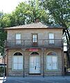
Rinehart Stone House Museum.
-
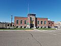
Old Vale City Hall
See also
 In Spanish: Vale (Oregón) para niños
