Ontario, Oregon facts for kids
Quick facts for kids
Ontario
|
||
|---|---|---|
| Ontario, Oregon | ||
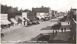
Main Street (now Oregon Street) looking south, early 1920s
|
||
|
||
| Motto(s):
Where Oregon Begins
|
||
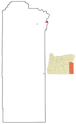
Location in Oregon
|
||
| Country | ||
| State | ||
| County | Malheur | |
| Incorporated | 1899 | |
| Named for | Ontario, Canada | |
| Area | ||
| • Total | 5.17 sq mi (13.38 km2) | |
| • Land | 5.17 sq mi (13.38 km2) | |
| • Water | 0.00 sq mi (0.00 km2) | |
| Elevation | 2,150 ft (655 m) | |
| Population
(2020)
|
||
| • Total | 11,645 | |
| • Density | 2,254.60/sq mi (870.42/km2) | |
| Time zone | UTC−7 (Mountain) | |
| • Summer (DST) | UTC−6 (Mountain) | |
| ZIP code |
97914
|
|
| Area code(s) | 541 | |
| FIPS code | 41-54900 | |
| GNIS feature ID | 1125001 | |
Ontario is the biggest city in Malheur County, Oregon, United States. It is located right next to the Snake River, which forms the border with Idaho. In 2020, about 11,645 people lived there.
Ontario is the largest town in the eastern part of Oregon. This area is also known as the Western Treasure Valley. The city is a main part of the Ontario, OR-ID Micropolitan Statistical Area. This area includes Malheur County in Oregon and Payette County in Idaho.
Ontario is about halfway between Portland and Salt Lake City. It is the closest city to the Idaho border along Interstate 84. The city's motto is "Where Oregon Begins."
Contents
History of Ontario
Ontario was started on June 11, 1883. Four people helped create it: William Morfitt, Mary Richardson, Daniel Smith, and James Virtue. In March 1884, Richard Welch opened a post office here. James Virtue named the town after Ontario, Canada.
Later, a man named Joseph Morton tried to start another post office nearby. But the original founders had more land and money. William Morfitt also arranged for a train station to be built in Ontario. Everyone knew how important the railroad would be for the town's future. So, the other post office closed, and its postmaster, Oscar Scott, built a hotel in Ontario instead. By December, Scott became Ontario's postmaster.
The town kept growing when the Oregon Short Line Railroad arrived in late 1884. This brought freight and passenger services to Ontario. Soon, cattle from Eastern Oregon's ranches came to Ontario's stockyard. From there, they were sent to markets across the Pacific Northwest. Ontario became one of the biggest stockyards in the West. Also, new canals helped farming grow, adding more products for Ontario to export.
Ontario officially became a city on February 11, 1899. This was decided by the Oregon Legislative Assembly.
During World War II, many Japanese Americans faced unfair treatment. They were often forced to leave their homes on the West Coast. However, Ontario's mayor, Elmo Smith, allowed Japanese Americans to settle in the city. He believed in helping them. Before the war, about 134 Japanese Americans lived in the area. During the war, this number grew to 1,000. The county welcomed them to help with farm work.
Geography and Climate
Ontario is located about 2,150 feet (655 meters) above sea level.
The United States Census Bureau says the city covers about 5.17 square miles (13.38 square kilometers). All of this area is land.
Ontario's Climate
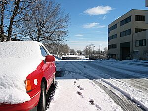
Ontario has a cold desert climate. This means winters are cold and snowy. Summers are hot, dry, and sunny.
The hottest temperature ever recorded was 113°F (45°C). This happened on August 4, 1961, and July 12, 1967. The coldest temperature was −25°F (−32°C). This was on January 27, 1957, and January 22, 1962.
On average, Ontario has:
- About 61 days a year where the temperature reaches at least 90°F (32°C).
- About 11 days a year where the temperature reaches at least 100°F (38°C).
- About 128 days a year where the temperature drops to 32°F (0°C) or below.
- About 2 days a year where the temperature drops to 0°F (−18°C) or below.
| Climate data for Ontario Municipal Airport, Ontario, Oregon (1991–2020 normals, extremes 1945–present) | |||||||||||||
|---|---|---|---|---|---|---|---|---|---|---|---|---|---|
| Month | Jan | Feb | Mar | Apr | May | Jun | Jul | Aug | Sep | Oct | Nov | Dec | Year |
| Record high °F (°C) | 64 (18) |
67 (19) |
85 (29) |
94 (34) |
103 (39) |
109 (43) |
113 (45) |
113 (45) |
104 (40) |
93 (34) |
74 (23) |
66 (19) |
113 (45) |
| Mean maximum °F (°C) | 49.1 (9.5) |
58.5 (14.7) |
71.0 (21.7) |
80.1 (26.7) |
91.0 (32.8) |
98.1 (36.7) |
104.2 (40.1) |
102.1 (38.9) |
94.7 (34.8) |
81.5 (27.5) |
63.2 (17.3) |
52.4 (11.3) |
104.7 (40.4) |
| Mean daily maximum °F (°C) | 38.3 (3.5) |
46.9 (8.3) |
58.4 (14.7) |
66.0 (18.9) |
76.4 (24.7) |
84.7 (29.3) |
95.1 (35.1) |
93.4 (34.1) |
82.7 (28.2) |
66.9 (19.4) |
49.8 (9.9) |
38.9 (3.8) |
66.5 (19.2) |
| Daily mean °F (°C) | 31.3 (−0.4) |
37.5 (3.1) |
46.1 (7.8) |
52.7 (11.5) |
62.1 (16.7) |
69.8 (21.0) |
78.3 (25.7) |
76.2 (24.6) |
66.0 (18.9) |
52.8 (11.6) |
39.7 (4.3) |
31.6 (−0.2) |
53.7 (12.1) |
| Mean daily minimum °F (°C) | 24.3 (−4.3) |
28.0 (−2.2) |
33.9 (1.1) |
39.4 (4.1) |
47.9 (8.8) |
54.9 (12.7) |
61.5 (16.4) |
58.9 (14.9) |
49.2 (9.6) |
38.7 (3.7) |
29.5 (−1.4) |
24.4 (−4.2) |
40.9 (4.9) |
| Mean minimum °F (°C) | 6.1 (−14.4) |
13.4 (−10.3) |
20.5 (−6.4) |
24.7 (−4.1) |
32.5 (0.3) |
41.1 (5.1) |
49.5 (9.7) |
45.4 (7.4) |
35.1 (1.7) |
23.7 (−4.6) |
14.4 (−9.8) |
7.8 (−13.4) |
0.8 (−17.3) |
| Record low °F (°C) | −25 (−32) |
−24 (−31) |
9 (−13) |
17 (−8) |
25 (−4) |
31 (−1) |
34 (1) |
33 (1) |
24 (−4) |
9 (−13) |
−6 (−21) |
−23 (−31) |
−25 (−32) |
| Average precipitation inches (mm) | 1.38 (35) |
0.89 (23) |
0.97 (25) |
0.77 (20) |
1.17 (30) |
0.72 (18) |
0.26 (6.6) |
0.12 (3.0) |
0.29 (7.4) |
0.64 (16) |
0.88 (22) |
1.39 (35) |
9.48 (241) |
| Average snowfall inches (cm) | 3.4 (8.6) |
1.2 (3.0) |
0.3 (0.76) |
0.0 (0.0) |
0.0 (0.0) |
0.0 (0.0) |
0.0 (0.0) |
0.0 (0.0) |
0.0 (0.0) |
0.0 (0.0) |
0.3 (0.76) |
5.0 (13) |
10.2 (26.12) |
| Average precipitation days (≥ 0.01 in) | 9.5 | 8.3 | 9.5 | 7.2 | 8.1 | 5.7 | 1.5 | 1.8 | 3.4 | 5.4 | 8.3 | 11.1 | 79.8 |
| Average snowy days (≥ 0.1 in) | 1.8 | 1.5 | 0.2 | 0.0 | 0.0 | 0.0 | 0.0 | 0.0 | 0.0 | 0.0 | 0.8 | 2.4 | 6.7 |
| Source 1: NOAA (snow/snow days 1981–2010) | |||||||||||||
| Source 2: National Weather Service | |||||||||||||
People of Ontario
| Historical population | |||
|---|---|---|---|
| Census | Pop. | %± | |
| 1890 | 200 | — | |
| 1900 | 445 | 122.5% | |
| 1910 | 1,248 | 180.4% | |
| 1920 | 2,039 | 63.4% | |
| 1930 | 1,941 | −4.8% | |
| 1940 | 3,551 | 82.9% | |
| 1950 | 4,465 | 25.7% | |
| 1960 | 5,101 | 14.2% | |
| 1970 | 6,523 | 27.9% | |
| 1980 | 8,814 | 35.1% | |
| 1990 | 9,392 | 6.6% | |
| 2000 | 10,985 | 17.0% | |
| 2010 | 11,366 | 3.5% | |
| 2020 | 11,645 | 2.5% | |
| Sources: U.S. Decennial Census |
|||
2020 Census Information
In 2020, there were 11,645 people living in Ontario. There were 4,315 households and 2,491 families.
Here's a look at the different groups of people in Ontario in 2020:
| Race | Number | Percentage |
|---|---|---|
| White (not Hispanic) | 5,692 | 48.88% |
| Black or African American (not Hispanic) | 125 | 1.07% |
| Native American or Alaska Native (not Hispanic) | 112 | 0.96% |
| Asian (not Hispanic) | 193 | 1.66% |
| Pacific Islander (not Hispanic) | 14 | 0.12% |
| Some Other Race (not Hispanic) | 45 | 0.39% |
| Mixed/Multi-Racial (not Hispanic) | 415 | 3.56% |
| Hispanic or Latino | 5,049 | 43.36% |
| Total | 11,645 |
2010 Census Information
In 2010, Ontario had 11,366 people. There were 4,275 households and 2,678 families. The city had about 2,199 people per square mile (849 per square kilometer).
Most people in Ontario were White (69.5%). About 41.3% of the population was Hispanic or Latino.
In 35.4% of households, there were children under 18. About 41.3% of households were married couples. The average household had 2.60 people. The average family had 3.28 people.
The average age in Ontario was 32.1 years.
- 28.9% of people were under 18.
- 12.3% were between 18 and 24.
- 23% were between 25 and 44.
- 21% were between 45 and 64.
- 14.9% were 65 or older.
There were slightly more females (52.7%) than males (47.3%).
Economy
The Heinz Frozen Food Company is a big employer in Ontario. It used to be called Ore-Ida. This company processes potatoes grown nearby. Each year, it makes over 600 million pounds (272 million kg) of potato products. About 1,000 people work there. Did you know that Tater tots were first made here in 1953?
St. Alphonsus Medical Center is a hospital in Ontario. It has 49 beds and serves Ontario and nearby towns in Oregon and Idaho. It is part of a larger hospital system based in Boise, Idaho.
About 5 miles (8 km) northwest of Ontario is the Snake River Correctional Institution. This is a large prison with 3,000 beds. It opened in 1991 and was made bigger in 1998. About 900 people work at the prison.
Education
Colleges and Universities
- Treasure Valley Community College
Schools for Kids (K-12)
Ontario is served by the Ontario School District (8C). Here are some of the schools:
- Ontario High School (grades 9-12)
- Ontario Middle School (grades 7-8)
- Aiken Elementary (grades K-5)
- Alameda Elementary (grades K-6)
- Cairo Elementary (grades K-5)
- May Roberts Elementary (grades K-6)
- Pioneer Elementary (grades K-5)
There is also a charter school:
- Four Rivers Community School (4RCC) - This school teaches grades K-12 and started in 2003.
The Annex School has an Ontario mailing address. However, it is located in the community of Annex, outside of Ontario.
- Private Schools
- Treasure Valley Christian School (Pre-Kindergarten to 12th grade)
- St. Peter's Catholic School (Roman Catholic Diocese of Baker) (grades K-8)
The Ontario Community Library is also located in Ontario.
Media
Ontario's daily newspaper is called the Argus Observer.
Transportation
Bus Services
- Snake River Transit offers public transportation. You can travel between places in Ontario and nearby towns like Fruitland and Payette.
- Ontario is a stop on the Eastern POINT bus line. This bus travels between Bend and Ontario once a day in each direction.
- Greyhound Lines also provides bus service from Ontario, going east and west on I-84.
Air Travel
- Ontario Municipal Airport
Highways
Famous People from Ontario
Many notable people have connections to Ontario:
- Cliff Bentz: A congressman for Oregon.
- Madeline DeFrees: A poet.
- Tom Edens: A pitcher in MLB.
- A. J. Feeley: A quarterback in the NFL.
- Erik Fisher: A World Cup alpine ski racer.
- Sally Flynn: A singer, also known as Sally Hart.
- Charles C. Gossett: A former governor and U.S. Senator for Idaho.
- Joel Hardin: A Border Patrol agent known for tracking.
- Denny Jones: An Oregon state representative and rancher.
- Randall B. Kester: An Oregon judge.
- Phyllis McGinley: A children's author.
- Elmo Smith: A newspaper editor, mayor of Ontario, and governor of Oregon.
- Leland Evan Thomas: A WWII pilot.
- Dave Wilcox: An NFL linebacker.
Sister City
Ontario has one sister city. This is a special friendship between cities in different countries:
 Ōsakasayama, Osaka, Japan
See also
 In Spanish: Ontario (Oregón) para niños
 | Audre Lorde |
 | John Berry Meachum |
 | Ferdinand Lee Barnett |


