Bully Creek (Malheur River tributary) facts for kids
Quick facts for kids Bully Creek |
|
|---|---|

Bully Creek Dam
|
|
|
Location of the mouth of Bully Creek in Oregon
|
|
| Country | United States |
| State | Oregon |
| County | Malheur |
| Physical characteristics | |
| Main source | Sheep Rock Blue Mountains, Malheur County, Oregon 4,278 ft (1,304 m) 44°05′25″N 118°05′55″W / 44.09028°N 118.09861°W |
| River mouth | Malheur River near Vale, Malheur County, Oregon 2,244 ft (684 m) 43°58′30″N 117°14′24″W / 43.97500°N 117.24000°W |
| Length | 62 mi (100 km) |
| Basin features | |
| Basin size | 601 sq mi (1,560 km2) |
Bully Creek is a river in Oregon, a state in the United States. It is about 62 miles (100 km) long. This creek flows into the Malheur River. Bully Creek starts in the Blue Mountains and travels southeast. It ends near the town of Vale. The creek helps drain a large area of Malheur County.
Contents
Where Does Bully Creek Flow?
Bully Creek begins high up near Sheep Rock. This area is in the southern part of the Blue Mountains. The creek first flows east. Along the way, it collects water from smaller streams like Indian, Cottonwood, and Clover creeks.
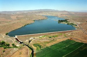
The creek then passes through the community of Westfall. After Westfall, it turns and flows northeast. A large structure called the Bully Creek Dam holds back the water. This dam is 161 feet (49 meters) tall and creates Bully Creek Reservoir.
From the reservoir, the creek flows southeast. It eventually reaches Highway 20. Bully Creek then runs alongside the highway and the Malheur River for several miles. It goes past the edges of Vale. Finally, Bully Creek joins the Malheur River. The Malheur River then flows into the Snake River, which leads to the Columbia River, and finally, the Pacific Ocean.
What is the Bully Creek Watershed Like?
A watershed is an area of land where all the water drains into a single river or body of water. The Bully Creek watershed covers about 601 square miles (1,557 square kilometers) in eastern Oregon.
This area has a dry climate. It is located between two special natural regions: the Northern Basin and Range and the Blue Mountains. The amount of rain and snow (precipitation) here is usually between 9 and 23 inches (229 to 584 mm) each year. On average, it gets about 12 inches (305 mm).
The highest point in the watershed is Juniper Mountain, which is 6,447 feet (1,965 meters) high. The lowest point is where Bully Creek meets the Malheur River, at 2,244 feet (684 meters) above sea level.
Animals and Plants of Bully Creek
Many different animals live in the Bully Creek watershed. Scientists have found 205 types of backboned animals (vertebrates) here.
You might see large mammals like elk and mule deer. Other animals include bobcats, beavers, otters, and raccoons. Twenty-one different kinds of fish live in the creek. However, there are no fish that travel from the ocean to lay eggs here. The bald eagle, a bird that is sometimes considered threatened, also lives in this area during the winter.
Most of the land in the Bully Creek watershed is covered by sagebrush. But along the creek banks, you can find different trees. These include Quaking Aspen, Water Birch, and Cottonwood trees. Some unwanted plants, called noxious weeds, have also been found. These include Russian Knapweed and White Top.
A Brief History of Bully Creek
People have lived in the Bully Creek area for a very long time. The first humans arrived about 13,000 years ago. The Northern Paiute tribe, a group of Native Americans, moved to this region about 1,000 years ago.
The first white explorers came through in 1811. They were fur traders from the Pacific Fur Company. Later, in the 1840s, 50s, and 60s, the famous Oregon Trail passed through this area.
Bully Creek has also seen big floods. On February 5, 1925, a dam used for watering crops broke. This happened about 19 miles (31 km) west of Vale. Melting snow and heavy rain caused the dam to fail. Floodwaters rushed down the creek. The town of Vale was covered in about 3 feet (1 meter) of water. This caused a lot of damage. A railroad bridge and parts of Highway 20 were washed away. Many cattle and homes were destroyed. The flood caused over $500,000 in damage.
To help prevent future floods, the Bully Creek Dam was built in 1963. Its main purpose is to control floods.
 | Aurelia Browder |
 | Nannie Helen Burroughs |
 | Michelle Alexander |


