
Fort Harney facts for kids
Quick facts for kids Fort Harney |
|
|---|---|
| Harney County, Oregon, United States | |

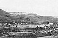
Camp Harney in 1872
|
|
| Coordinates | 43°40′03″N 118°48′28″W / 43.66750°N 118.80778°W |
| Type | Military cantonments |
| Site information | |
| Owner | Private property |
| Site history | |
| Built | 1867 |
| Built by | United States Army |
| In use | 1867–1880 |
Fort Harney was an important United States Army base in eastern Oregon. It was named after Brigadier General William S. Harney. The fort was used from 1867 to 1880. It served as a supply center and main office during the Army's fights against Northern Paiute groups. It also played a role in the Bannock War. Today, only a small cemetery remains where Fort Harney once stood.
Contents
Building Camp Harney
In 1864, the Army started using a spot near Rattlesnake Creek in Harney County, Oregon. They used it to drop off supplies temporarily. People called this place Rattlesnake Camp.
More and more settlers and miners began traveling through eastern Oregon. They needed protection from Native American raiding parties. Because of this, the Army decided to build permanent bases in the area. Rattlesnake Creek was a great spot for a supply depot and headquarters. So, on August 16, 1867, the Army set up a permanent base there.
The new base was first named Camp Steele. But Major General Henry W. Halleck, who was in charge of the Military Department of the Pacific, didn't like the name. He suggested naming it after Brigadier General William S. Harney. General Harney had led the Army's Department of Oregon a few years earlier. So, on September 14, 1867, the base was officially named Camp Harney. The first soldiers there were from Company K of the 23rd Infantry Regiment.
Important Military Events
From 1867 to 1868, General George Crook led soldiers and Wasco and Warm Springs Indian scouts. They fought against Northern Paiute groups in eastern Oregon and northern California. This conflict was part of what was known as the Snake War. Camp Harney was a key base for supplying General Crook's troops during these battles.

The Native American raids in eastern Oregon mostly stopped in 1869. This happened after General Crook and Wewawewa, a chief of the main Paiute group, signed a peace treaty. The treaty signing ceremony took place at Fort Harney.
In 1872, the local Paiute groups were moved to a large reservation. This reservation was north of Malheur Lake in eastern Oregon. Camp Harney was actually inside the reservation's border. Soldiers at the camp were supposed to protect the reservation from white settlers. They also tried to keep the Paiutes from leaving. However, white settlers still used the reservation land for grazing their animals. This problem helped start the Bannock War in 1878.
During the Bannock War, Camp Harney was again a very important supply and command center for the Army. The camp was right in the middle of the fighting. Some newspapers even reported that Native American warriors might take over Camp Harney. But the United States Army, led by General Oliver O. Howard, quickly defeated the Bannocks and Paiutes.
By January 1879, 543 Bannock and Paiute prisoners were held at Camp Harney. After the war, these prisoners were moved to the Yakama Indian Reservation. This reservation was in the Washington Territory, about 350 miles (563 km) north of the Malheur reservation.
The Army officially changed the base's name to Fort Harney on April 5, 1879. But since there was no longer a reservation to guard, the fort wasn't needed. So, Fort Harney was closed on June 13, 1880.
Later, in 1882, the Malheur reservation lands were given back to the public. However, the 320-acre (1.3 km²) Fort Harney site was kept by the Army. The Army finally returned this land to the public in 1889. After the fort closed, local settlers took apart the buildings. They used many of the materials to build the nearby town of Harney City. Today, only a small cemetery marks where Fort Harney once stood.
Fort Buildings and Layout
In 1867, Camp Harney was a busy place and grew quickly. It was in the high desert area of eastern Oregon. The fort was built on flat land west of Rattlesnake Creek. This area was between steep ridges that ran along the stream. North of the fort, there were pine trees. These trees provided timber for the camp's sawmill.
By 1877, Camp Harney was a well-developed frontier outpost. It had a large parade ground in the middle. Around it were the headquarters building and guardhouses. There was a home for the commanding officer and five other houses for officers. Some were made of logs, and others were frame buildings.
The fort had three log barracks for the soldiers. There were also four log houses for soldiers with families. To feed everyone, the camp had mess halls, kitchens, a bakery, and a slaughter house for fresh meat.
Other important buildings included storehouses for supplies, a military commissary, and a hospital. There was also a blacksmith shop and stables for 150 horses. Besides the Army troops, the fort also had civilian workers. These included clerks, masons, a saddlemaker, a shoemaker, a painter, a baker, and laundry maids.
Where to Find Fort Harney Today
The historic Fort Harney site is about 16 miles (26 km) east of Burns, Oregon. To get there from Burns, you take U.S. Highway 20 east for 12 miles (19 km). Then, you turn north onto a gravel road that leads to the old town of Harney City. Harney City is about 2 miles (3 km) from the highway. The Fort Harney site itself is on private land, about 2 miles (3 km) north of the Harney City town site.
Images for kids
-
Camp Harney in 1872
