Alkali Lakes (California) facts for kids
Quick facts for kids Alkali Lakes |
|
|---|---|

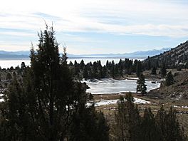
A flooded Upper Alkali Lake is seen from Fandango Pass in the Warner Mountains in January 2012
|
|
| Location | Modoc County, California and Washoe County, Nevada |
| Coordinates |
|
| Type | Endorheic basin, alkaline, seasonal |
| Part of | Great Basin |
| Primary outflows | None |
| Catchment area | 878 sq mi (2,270 km2) |
| Basin countries | United States |
| Surface area | 370 sq mi (960 km2) (Total) |
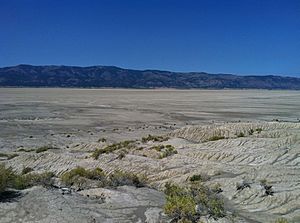
The Alkali Lakes are a group of three large, flat areas that are usually dry, found in the Surprise Valley in northeastern California, United States. These areas are called Upper, Middle, and Lower Alkali Lake, going from north to south. Sometimes, Upper Alkali Lake is just called Upper Lake, and Lower Alkali Lake is called Lower Lake.
Most of these lakes are in Modoc County, California. However, the eastern edges of Middle and Lower Lakes reach into Washoe County, Nevada. The Warner Mountains are located to the west of these three lakes. The lake beds usually fill with shallow water in the winter. But they often dry up completely during most summers.
Contents
Where are the Alkali Lakes?
The town of Fort Bidwell is at the north end of Upper Alkali Lake. Lake City and Cedarville are located between Upper and Middle Alkali Lakes, to their west. Eagleville is south of Lower Alkali Lake. California State Route 299 crosses the area between the Upper and Middle lakes.
The lakes are about 40 miles (64 km) east of Alturas. They are also about 150 miles (240 km) northeast of Redding.
How the Lakes Were Formed
The lakes sit in a deep valley created by the Surprise Valley Fault. This fault has caused the land to drop almost a mile (1.6 km). This created the steep eastern side of the Warner Mountains.
These lakes are what's left of a huge ancient lake called Glacial Lake Lahontan. This giant lake existed about 12,000 years ago during the last Ice Age. Scientists have found layers of dirt and rock that show Lake Lahontan was once up to 550 feet (168 m) deep in this area. If it were that deep today, it would fill the entire valley.
Life Around the Lakes
People have used the land around the lakes for farming since the first settlers arrived in the 1840s. The valley was named "Surprise" because it had lots of green plants. These plants grew thanks to streams flowing from the Warner Mountains. This was a big surprise compared to the dry high desert land around it.
In recent times, with more water being used and dry weather, the amount of groundwater (water under the ground) in the area is becoming a worry. People used to get salt from salty wells on the east side of Middle Alkali Lake. This continued until 1943.
How Water Flows in the Lakes
The Alkali Lakes are part of a "closed" water system. This means water flows into them but doesn't flow out to oceans or other rivers. This system is on the western edge of the Great Basin.
Together, the lakes cover about 370 square miles (958 km²). They collect water from a large area of 878 square miles (2,274 km²). They are considered part of California's North Lahontan watershed.
Even though they are called Upper, Middle, and Lower, water doesn't just flow from north to south. Middle Alkali Lake is actually the highest, at 4,478 feet (1,365 m) above sea level. Water can flow south from Middle Lake to Lower Alkali Lake, which is at 4,472 feet (1,363 m). Or, it can flow north to Upper Alkali Lake, which is at 4,449 feet (1,356 m).
The lakes usually fill with salty water in most years, but they dry out in the summer. The area gets about 13 to 17 inches (330 to 430 mm) of rain each year. About 160,000 acre-feet (197 million m³) of water flows into the lakes each year. Most of this happens between March and June when snow melts. This amount of water is enough to cover the lake beds about 8 inches (20 cm) deep. However, much of this water is used for farming or evaporates in the desert heat.
The lake beds are made of deep layers of sand and gravel, up to 5,000 feet (1,500 m deep) at Middle Alkali Lake. These layers hold a lot of groundwater. The Surprise Valley Groundwater Basin, which covers 228,460 acres (92,450 ha), is estimated to hold about 4 million acre-feet (4.9 km³) of water.
Upper Alkali Lake
This is the northernmost lake. It collects water from an area of 318 square miles (824 km²). Streams like Bidwell, Second, Goose, Wilkinson, Mill, Releford, and Soldier Creeks feed into it. It also gets water from Middle Alkali Lake if that lake's water level is very high.
Middle Alkali Lake
Middle Alkali Lake is the largest of the three lakes. It has the biggest area for collecting water, covering 376 square miles (974 km²). Many creeks flow into it, including Sand, Fortymile, Cedar, Deep, Granger, Milk, Cottonwood, Owl, and Raider Creeks. Between Middle and Lower Alkali Lakes, there is a smaller lake called Cambron Lake. Highrock and Eagle Creeks feed into Cambron Lake.
Lower Alkali Lake
Lower Alkali Lake is the southernmost and smallest of the three lakes. It collects water from an area of 212 square miles (549 km²). Streams that feed this lake include Emerson, Barber, and Bare Creeks. It also sometimes gets extra water from Middle Alkali Lake.
 | Aaron Henry |
 | T. R. M. Howard |
 | Jesse Jackson |


