Hesperia, California facts for kids
Quick facts for kids
Hesperia
|
|||
|---|---|---|---|

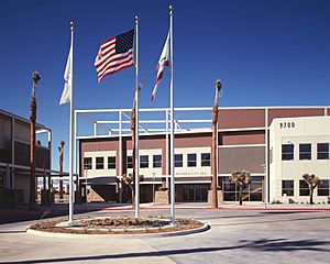
Hesperia City Hall
|
|||
|
|||

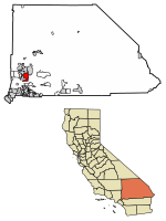
Location of Hesperia in San Bernardino County, California.
|
|||
| Country | |||
| State | |||
| County | |||
| Incorporated | July 1, 1988 | ||
| Government | |||
| • Type | General Law City Council–manager |
||
| Area | |||
| • Total | 72.78 sq mi (188.50 km2) | ||
| • Land | 72.69 sq mi (188.26 km2) | ||
| • Water | 0.10 sq mi (0.25 km2) 0.15% | ||
| Elevation | 3,186 ft (971 m) | ||
| Population
(2010)
|
|||
| • Total | 90,173 | ||
| • Estimate
(2020)
|
99,818 | ||
| • Rank | 77th in California | ||
| • Density | 1,317.31/sq mi (508.62/km2) | ||
| Time zone | UTC−8 (PST) | ||
| • Summer (DST) | UTC−7 (PDT) | ||
| ZIP Codes |
92340, 92344, 92345
|
||
| Area codes | 442/760 | ||
| FIPS code | 06-33434 | ||
| GNIS feature IDs | 1652720, 2410751 | ||
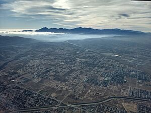
Hesperia (/hɛˈspɪəriə/) is a city in San Bernardino County, California, United States. It is about 35 miles north of downtown San Bernardino. The city is located in the Victor Valley and is surrounded by the Mojave Desert. Hesperia is known as part of the "High Desert" because of its higher elevation and unique weather. The name "Hesperia" means "western land." In 2019, the city's population was estimated to be 95,750 people.
Contents
History of Hesperia
Early Inhabitants and Spanish Rule
The first people to live in the Hesperia area were the Desert Serrano (also called Vanyume). They had villages along the Mojave River, including one called Wá’peat. These villages were active until the early 1800s. People from different villages would gather at Wá’peat for a special acorn-gathering festival.
Hesperia started as a Spanish land grant in 1781. This grant was called Rancho San Felipe, Las Flores y el Paso del Cajon. During Spanish and Mexican rule in the 1800s, the desert land was not very populated. The United States took control of Southern California, including this area, after the Mexican–American War in 1848.
Growth and Development
In 1869, Max Stobel bought 35,000 acres of land for $40,000. People tried to divide the land and encourage more settlers. However, the land was mostly used for farming, especially for growing raisin grapes.
The town of Hesperia was officially planned in 1891. This was done by land developers from the Santa Fe Railroad. The railroad was finished that same year. Hesperia was named after Hesperus, the Greek god of the West. The developers hoped Hesperia would become a big city, but only about 1,000 people moved there at first.
Hesperia grew slowly until major roads were built in the 1940s. These included U.S. Route 66, California State Route 91, and 395. Later, Interstate 15 was completed in the late 1960s. About 30 square miles of land were set aside for homes.
In the early 1950s, a land developer named M. Penn Phillips and boxer Jack Dempsey helped build roads and sell land. They advertised on television. They also built the Hesperia Inn and a golf course. Many Hollywood celebrities visited the Hesperia Inn, which also had the Jack Dempsey Museum.
The biggest wave of new residents came to Hesperia in the 1980s. The town grew from 5,000 people in 1970 to over 60,000 by 2000. By July 1, 2018, the population was estimated to be over 95,000.
Geography of Hesperia
Hesperia is located in the Mojave Desert. The California Aqueduct, a large water channel, runs through the area. The natural plants in Hesperia are desert plants. These include junipers, Joshua trees, and sagebrush. The land rises from 3,200 feet in the north to about 4,000 feet above sea level in the south.
The San Andreas Fault is a major crack in the Earth's crust. It is a few miles south of Hesperia in the Cajon Pass. This area sometimes has earthquakes.
Hesperia is 3,186 feet above sea level. It is next to Victorville, Oak Hills, and Apple Valley. The Mojave River flows north through the east side of the city. The California Aqueduct divides the city from north to south. It carries water to Silverwood Lake.
The United States Census Bureau says Hesperia covers 73.2 square miles. Most of this (73.1 square miles) is land, and a small part (0.1 square miles) is water. On the southern edge of Hesperia, near the airport, there is a flat-topped hill called a mesa.
Climate in Hesperia
Hesperia has a cold desert climate. This means it is dry and can have cold winters.
Winter days are cool, usually around 60°F. But nights get cold, often around freezing in December and January. This is also the wet season. Mountains to the south and west block most winter rain. However, heavy rain can still happen. Snowfall is not common, but Hesperia gets about 4.4 inches of snow each year.
Summer days are very hot, often reaching close to 100°F. This is typical for the Mojave Desert. However, the temperature drops a lot at night, which brings relief from the heat. In late summer, thunderstorms can happen. These are part of the North American monsoon and can cause power outages and flash floods.
| Climate data for Hesperia, California | |||||||||||||
|---|---|---|---|---|---|---|---|---|---|---|---|---|---|
| Month | Jan | Feb | Mar | Apr | May | Jun | Jul | Aug | Sep | Oct | Nov | Dec | Year |
| Record high °F (°C) | 80 (27) |
87 (31) |
93 (34) |
100 (38) |
108 (42) |
111 (44) |
116 (47) |
112 (44) |
113 (45) |
101 (38) |
88 (31) |
85 (29) |
116 (47) |
| Mean daily maximum °F (°C) | 60 (16) |
63 (17) |
69 (21) |
75 (24) |
85 (29) |
94 (34) |
99 (37) |
99 (37) |
93 (34) |
81 (27) |
69 (21) |
60 (16) |
79 (26) |
| Mean daily minimum °F (°C) | 32 (0) |
35 (2) |
39 (4) |
44 (7) |
50 (10) |
56 (13) |
62 (17) |
62 (17) |
56 (13) |
46 (8) |
37 (3) |
31 (−1) |
46 (8) |
| Record low °F (°C) | −1 (−18) |
11 (−12) |
14 (−10) |
25 (−4) |
30 (−1) |
36 (2) |
35 (2) |
42 (6) |
32 (0) |
21 (−6) |
8 (−13) |
6 (−14) |
−1 (−18) |
| Average precipitation inches (mm) | 1.09 (28) |
1.26 (32) |
0.88 (22) |
0.35 (8.9) |
0.14 (3.6) |
0.05 (1.3) |
0.19 (4.8) |
0.20 (5.1) |
0.18 (4.6) |
0.36 (9.1) |
0.47 (12) |
1.02 (26) |
6.19 (157) |
| Source: The Weather Channel | |||||||||||||
People of Hesperia
Population Growth Over Time
Hesperia has grown a lot over the years. Here's how the population has changed:
| Historical population | |||
|---|---|---|---|
| Census | Pop. | %± | |
| 1970 | 4,592 | — | |
| 1980 | 13,540 | 194.9% | |
| 1990 | 50,418 | 272.4% | |
| 2000 | 62,582 | 24.1% | |
| 2010 | 90,173 | 44.1% | |
| 2020 | 99,818 | 10.7% | |
| U.S. Decennial Census | |||
Who Lives in Hesperia?
The city is home to a diverse group of people. Here is a look at the different racial and ethnic groups in Hesperia:
| Race / Ethnicity (NH = Non-Hispanic) | Pop 2000 | Pop 2010 | Pop 2020 | % 2000 | % 2010 | % 2020 |
|---|---|---|---|---|---|---|
| White alone (NH) | 39,057 | 37,027 | 29,444 | 62.41% | 41.06% | 29.50% |
| Black or African American alone (NH) | 2,388 | 4,853 | 5,255 | 3.82% | 5.38% | 5.26% |
| Native American or Alaska Native alone (NH) | 469 | 412 | 427 | 0.75% | 0.46% | 0.43% |
| Asian alone (NH) | 619 | 1,704 | 2,193 | 0.99% | 1.89% | 2.20% |
| Pacific Islander alone (NH) | 102 | 205 | 205 | 0.16% | 0.23% | 0.21% |
| Other race alone (NH) | 91 | 164 | 565 | 0.15% | 0.18% | 0.57% |
| Mixed race or Multiracial (NH) | 1,456 | 1,717 | 3,081 | 2.33% | 1.90% | 3.09% |
| Hispanic or Latino (any race) | 18,400 | 44,091 | 58,648 | 29.40% | 48.90% | 58.75% |
| Total | 62,582 | 90,173 | 99,818 | 100.00% | 100.00% | 100.00% |
In 2010, Hesperia had 90,173 people. Most people lived in homes, with an average of 3.41 people per household. About 49.8% of households had children under 18. The median age was 30.5 years.
In 2000, there were 62,582 people. The average household had 3.1 people. About 32.8% of the population was under 18. The median age was 32 years.
Economy in Hesperia
The biggest employers in Hesperia help many people in the city. Here are some of the main employers:
| # | Employer | # of Employees |
|---|---|---|
| 1 | Hesperia Unified School District | 2,817 |
| 2 | County of San Bernardino | 648 |
| 3 | Walmart Supercenter | 405 |
| 4 | Super Target | 320 |
| 5 | Stater Bros. Markets | 320 |
| 6 | City of Hesperia | 261 |
| 7 | Arizona Pipeline Company | 213 |
| 8 | In-N-Out Burger | 143 |
| 9 | Robar Ent/Hi Grade Material | 129 |
| 10 | Double Eagle Transportation | 126 |
| 11 | Hesperia Recreation & Park District | 106 |
Arts and Culture in Hesperia
Hesperia has a special man-made lake called Hesperia Lake Park. Many city events happen here, like the yearly Hesperia Day. You can go camping and fishing at the lake. There are also day camps and sports leagues for kids.
Near Hesperia Lake Park is the Radio Control Model Aircraft Park. This is where the Victor Valley R/C Flyers fly their model airplanes. Members can use the park every day.
Hesperia's golf course is famous for its narrow paths and fast greens. In the 1950s and 1960s, it was even a stop on the PGA Tour.
The Mojave River flows through the east side of Hesperia. It is usually dry underground, but it fills up when Hesperia gets heavy rain. Hesperia is next to Victorville to the north and Apple Valley to the east.
Hesperia is also home to Cal-Earth. This is a group that teaches a special way to build homes. It is especially useful for hot, dry places. The method is called Superadobe.
Parks and Recreation in Hesperia
The Hesperia Recreation and Park District helps provide fun activities for everyone. It was started in 1957. The district has many indoor and outdoor places for recreation. The Southern California Hardball Association is a baseball league for adults over 28. It serves people living in Hesperia.
Education in Hesperia
Most of Hesperia is part of the Hesperia Unified School District. This district has three high schools: Hesperia High School, Sultana High School, and Oak Hills High School. There are also two continuation high schools for students who need a different learning path. The district has three junior high schools and 14 elementary schools.
A small part of Hesperia is in the Snowline Joint Unified School District.
Hesperia also has other school choices. Mirus Secondary School is a charter school for grades 6-12. It offers an independent study program. Hesperia Christian School, founded in 1966, is a K-12 Christian school.
Transportation in Hesperia
The main roads in Hesperia include Ranchero Road, Main Street, and Bear Valley Road. Many major streets have bike lanes. There are also several paths for walking and biking in the city. Interstate 15 runs through the city, just north of the Cajon Pass.
The Victor Valley Transit Authority provides public transportation. The BNSF Railway offers train service through Hesperia. This line connects Los Angeles to Barstow and other places to the east. Union Pacific freight trains and Amtrak’s Southwest Chief also use this line. The closest Amtrak station is in Victorville, about 13 miles north. There is also a plan for a high-speed rail station in Hesperia as part of Brightline West.
Lua error: unknown error.
Hesperia Airport is a public airport. It is about 3.2 miles south of Hesperia's main business area.
Notable People from Hesperia
- Dan Henderson, a mixed martial arts (UFC) fighter
- Buck Page, a musician and singer, founder of the Riders of the Purple Sage band
- Marcel Reece, a former fullback for the Oakland Raiders
- Chris Smith, a coach and former Major League Baseball player
- Joe Stevenson, a mixed martial arts fighter
- George Connor, a retired Indy Car driver
- Dominick Reyes, a mixed martial arts (UFC) fighter
- Lee Rodriguez, an actress
- Thurston Smith, a businessman and politician
- Joel Pimentel, a vocalist and former member of CNCO
See also
 In Spanish: Hesperia (California) para niños
 | Dorothy Vaughan |
 | Charles Henry Turner |
 | Hildrus Poindexter |
 | Henry Cecil McBay |


