
Mount Harwood facts for kids
Quick facts for kids Mount Harwood |
|
|---|---|

Mount Harwood (center) and Devil's Backbone (right) from the southeast, February 2008.
|
|
| Highest point | |
| Elevation | 9,556 ft (2,913 m) NAVD 88 |
| Prominence | 152 ft (46 m) |
| Parent peak | Mount San Antonio |
| Listing | Hundred Peaks Section |
| Geography | |
| Location | San Bernardino County, California, U.S. |
| Parent range | San Gabriel Mountains |
| Topo map | USGS Mount San Antonio |
| Climbing | |
| Easiest route | Hike, class 1 |
Mount Harwood is a tall mountain peak located in the San Gabriel Mountains in California. It's the first major peak you see just east of Mount San Antonio, which is also known as "Old Baldy." At 9,556 feet (2,913 meters) high, Mount Harwood is the fourth tallest peak in the San Gabriel Mountains!
This mountain was named in 1965 to honor Aurelia Squire Harwood. She was an important Californian who worked to protect nature and educate people. Before this, another peak, now called Thunder Mountain, was sometimes called Mount Harwood.
Mount Harwood is found in the Angeles National Forest, close to where San Bernardino County and Los Angeles County meet. This area of the San Gabriel Mountains has some of the highest peaks. To visit Mount Harwood, hikers and tourists usually take Mt. Baldy Road off I-210. Remember, you'll need to display a National Forest Adventure Pass or National Park access pass on your vehicle.
Mountain Climate
Mount Harwood experiences a special kind of weather called a Highlands or Mediterranean Climate. This means the summers are usually hot and very dry. In contrast, the winters are cold and wet. During the winter months, Mount Harwood and most of the San Gabriel Mountains are covered in snow. Because of this high-elevation climate, you'll find mixed conifer forests growing on the mountain's slopes. However, the very top of the peak is too high and exposed for trees to grow.
Gallery
-
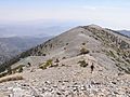
Mount Harwood's west ridge, August 2007. Devil's Backbone Trail passes the summit to the right.
-
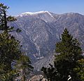
Mount Harwood (right), beside Mount San Antonio (center).
-
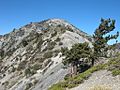
Mount Harwood from Devils Backbone Trail.


